Skip to search
Skip to main content
Skip to first result
Search
You Searched For
Format
cartographic
Language
Italian
New Search
Search Results
Creator:
Published / Created:
1576]
Call Number:
855 1576A
Container / Volume:
BRBL_00695
Image Count:
2
Resource Type:
Maps, Atlases & Globes
Alternative Title:
Cuba, Descrittione dell' isola Cuba, and Descrittione dell' isola Cvba
Description:
Cross Collection no. 275., From author's L'isole piu famose del mondo, 1576., and Relief shown pictorially.
Publisher:
Appresso S. Galignani & G. Porro,
Subject (Geographic):
Cuba--Maps--Early works to 1800
Subject (Name):
Galignani, Simon, printer, Porcacchi, Thomaso, ca. 1530-1585? Isole piu famose del mondo, and Porro, Girolamo, 1520-1604, printer
Found in:
Beinecke Rare Book and Manuscript Library > Cvba.
Creator:
Published / Created:
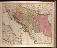
[1710?]
Call Number:
1973 Folio 18
Image Count:
1
Resource Type:
Maps, Atlases & Globes
Description:
Backed with paper. Ms. no. "77" in upper right corner. Sheet measures 53.6 x 62.5 cm. No. 71 of 87 maps bound together., Bar scales given in "milliaria Hungarica" and "milliaria Germanica.", Covers Croatia, Bosnia and Hercegovina, Serbia, Montenegro and portions of Italy, Albania, Greece, Macedonia and Hungary., In Latin with place names in Italian., and Relief shown pictorially.
Publisher:
Gerardum et Leonardum Valk,
Subject (Geographic):
Balkan Peninsula--Maps--Early works to 1800.
Subject (Name):
Valck, Leonard, 1675-1746.
Found in:
Beinecke Rare Book and Manuscript Library > Dalmatia, Sclavonia, Croatia, Bosnia, Servia, et Istria [cartographic material] : distributa in singulares ditiones et diœceses, una cum Republica Ragusana, et circumjacentibus regionibus, Hungaria, Venetiis, statu ecclesiastico, Napoli et Macedonia / Venundantur per Gerardum et Leonardum Valk, cum Priv.
Published / Created:
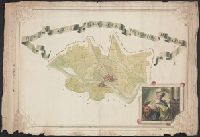
[1780?]
Call Number:
40 P28 1780B
Container / Volume:
BRBL_00705
Image Count:
1
Resource Type:
Maps, Atlases & Globes
Description:
Color: various shades of green with some yellow detail. and Notes: Drawing in lower right hand corner possibly depicting Judith and Holofernes.
Subject (Geographic):
Italy--Maps, Manuscript--Early works to 1800
Found in:
Beinecke Rare Book and Manuscript Library > Del e Gazione Prima del Principato di Pavia.
Call Number:
40 C499 1840B
Container / Volume:
BRBL_00206
Image Count:
1
Resource Type:
Maps, Atlases & Globes
Alternative Title:
Atlante geografico dell'Italia.
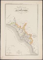
Description:
"Atlante geografico dell'Italia ; Stato Pontificio ; No. 16"--At top of map sheet., Hand colored., and Relief shown by hachures.
Subject (Geographic):
Civitavecchia (Italy)--Maps and Papal States--Maps
Subject (Name):
Maina, G, Manzoni, P, Stanghi, V, and Vallardi, Francesco
Found in:
Beinecke Rare Book and Manuscript Library > Delegazione di Civitavecchia / G. Maina e V. Stanghi inc. ; P. Manzoni scrisse.
Call Number:
40 C499 1840
Container / Volume:
BRBL_00206
Image Count:
1
Resource Type:
Maps, Atlases & Globes
Alternative Title:
Atlante geografico dell'Italia. Stato Pontificio.
Description:
"Atlante geografico dell'Italia ; Stato Pontificio"--At top of map sheet., Hand colored., and Relief shown by hachures.
Subject (Geographic):
Civitavecchia (Italy)--Maps and Papal States--Maps
Subject (Name):
Vallardi, Francesco
Found in:
Beinecke Rare Book and Manuscript Library > Delegazione di Civitavecchia.
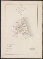
Call Number:
40 F388 1840
Container / Volume:
BRBL_00207
Image Count:
1
Resource Type:
Maps, Atlases & Globes
Alternative Title:
Atlante geografico dell'Italia.
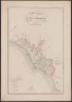
Description:
"Atlante geografico dell'Italia ; Stato Pontificio ; N. 10"--At top of map sheet., Hand colored., and Relief shown by hachures.
Subject (Geographic):
Fermo (Italy)--Maps and Papal States--Maps
Subject (Name):
Maina, G, Pozzi, G, and Vallardi, Francesco
Found in:
Beinecke Rare Book and Manuscript Library > Delegazione di Fermo / G. Maina e G. Pozzi inc. ; G. Pozzi scrisse.
Call Number:
40 F929 1840
Container / Volume:
BRBL_00208
Image Count:
1
Resource Type:
Maps, Atlases & Globes
Alternative Title:
Atlante geografico dell'Italia.
Description:
"Atlante geografico dell'Italia ; Stato Pontificio ; No. 18."--At top of map sheet., Hand colored., and Relief shown by hachures.
Subject (Geographic):
Frosinone (Italy)--Maps and Papal States--Maps
Subject (Name):
Maina, G, Manzoni, P, Stanghi, V, and Vallardi, Francesco
Found in:
Beinecke Rare Book and Manuscript Library > Delegazione di Frosinone / G. Maina e V. Stanghi inc. ; P. Manzoni scrisse.
Published / Created:
[1860?]
Call Number:
40 F929 1860
Container / Volume:
BRBL_00208
Image Count:
1
Resource Type:
Maps, Atlases & Globes
Description:
In upper margin: Atlante Geografico dell'Italia.
Publisher:
Dr. Francesco Vallardi, Tipografo-Editore,
Subject (Geographic):
Frosinone (Italy : Province)--Maps
Found in:
Beinecke Rare Book and Manuscript Library > Delegazione di Frosinone.
Branch:v1.61.6 ,Deployed:2024-06-12T09:55:19-04:00