Skip to search
Skip to main content
Skip to first result
Search
You Searched For
Extent of Digitization
Completely digitized
Resource Type
Maps, Atlases & Globes
New Search
Search Results
Published / Created:
[1910?]
Call Number:
3771 1910
Container / Volume:
BRBL_00150A
Image Count:
1
Resource Type:
Maps, Atlases & Globes
Publisher:
F. Rouge, Editeur,
Subject (Geographic):
Vaud (Switzerland)--Maps
Found in:
Beinecke Rare Book and Manuscript Library > Carte du Canton de Vaud Adoptée pour les Ecoles par le Département de L'instruction publique / dressée par J. Randegger.
Creator:
Published / Created:
1708 [i.e. 1718?]
Call Number:
64 1718
Container / Volume:
BRBL_00338
Image Count:
1
Resource Type:
Maps, Atlases & Globes
Description:
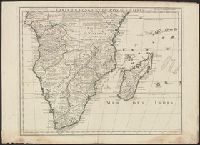
"Avec privilege Janvier 1708.", "The words 'premier geographe du Roi' added in the title ... [indicate] that [a map] could not have been issued before 1718 when [De l'Isle] was appointed to that office"--Tooley, R.V. Guide to maps, and Relief shown pictorially.
Publisher:
chez l'auteur sur le Quai de l'Horloge,
Subject (Geographic):
Africa, Central--Maps--Early works to 1800 and Africa, Southern--Maps--Early works to 1800
Found in:
Beinecke Rare Book and Manuscript Library > Carte du Congo et du pays des Cafres / par G. De l'Isle de l'academie royale des sciences, premier geographe du Roy.
Published / Created:
1912
Call Number:
38gme P21 1912A
Container / Volume:
BRBL_00171
Image Count:
1
Resource Type:
Maps, Atlases & Globes
Description:
In lower left margin: "Juin 1912"
Subject (Geographic):
Paris (France)--Maps
Found in:
Beinecke Rare Book and Manuscript Library > Carte du Départment de la Seine [cartographic material] : réseaux de tramways.
Published / Created:
1708
Call Number:
3884 B462 1708
Image Count:
1
Resource Type:
Maps, Atlases & Globes
Description:
Inset: Plan of Beziers. and Tables of data on Margins.
Subject (Geographic):
Hérault (France)--Maps--Early works to 1800
Found in:
Beinecke Rare Book and Manuscript Library > Carte du Diocese de Beziers ... Par G. Del'Isle.
Published / Created:
[1753]
Call Number:
339 1753
Container / Volume:
BRBL_00090
Image Count:
1
Resource Type:
Maps, Atlases & Globes
Description:
Preliminary record.
Subject (Geographic):
Luxemburg (Grand Duchy)--Maps--Early works to 1800
Found in:
Beinecke Rare Book and Manuscript Library > Carte du Duche de Luxembourg ... Par le Sr. Robert de Vaugondy.
Published / Created:
[1860?]
Call Number:
37ceh N39 1860
Container / Volume:
BRBL_00150A
Image Count:
1
Resource Type:
Maps, Atlases & Globes
Publisher:
Imp. á lithog. de A. Sonrel,
Subject (Geographic):
Neuchâtel (Switzerland)--Maps
Found in:
Beinecke Rare Book and Manuscript Library > Carte du Fond des tacs de Neuchatel et de Morat ... par Cte. H. de Pourtalés Georgier. Lith. Anst. c. H. Delius.
Published / Created:
1773
Call Number:
38175 1773
Container / Volume:
BRBL_00174
Image Count:
1
Resource Type:
Maps, Atlases & Globes
Description:
Preliminary record.
Publisher:
Sr. Daumont,
Subject (Geographic):
Mayenne (France)--Maps--Early works to 1800
Found in:
Beinecke Rare Book and Manuscript Library > Carte du Gouvernement General du Maine et Perche ... D.D.La Fosse ... Paris ... 1773 Grave par l'Auteur.
Published / Created:
1840
Call Number:
68 1840
Container / Volume:
BRBL_00349
Image Count:
1
Resource Type:
Maps, Atlases & Globes
Description:
Insets: Environs d'Alger, Environs de Constantine ... and Preliminary record.
Subject (Geographic):
Algeria--Maps
Found in:
Beinecke Rare Book and Manuscript Library > Carte du Gouvernt. D'Alger. D'une Partie du Bassin de la Mediterranee. Donnan-t le rapport qui existe Entre la France et les Etats Barbaresques. Para. H. Dufour. Nelle Edition, Par Ch. Piquett en 1840.
Creator:
Published / Created:
[1940]-
Call Number:
37 J974 1940
Image Count:
2
Resource Type:
Maps, Atlases & Globes
Alternative Title:
Spezialkarte des Jura
Description:
French and German., Relief shown by contours, gradient tints, and spot heights. Contours at 20 meter intervals., Sheets 2-6 wanting., and Shows hiking trails and paths.
Publisher:
Institut géographique Kümmerly & Frey,
Subject (Geographic):
Jura Mountains (France and Switzerland)--Maps
Subject (Name):
Kümmerly + Frey
Subject (Topic):
Hiking--Jura Mountains (France and Switzerland)--Maps and Trails--Jura Mountains (France and Switzerland)--Maps
Found in:
Beinecke Rare Book and Manuscript Library > Carte du Jura = Spezialkarte des Jura / editée par le Schweizerischen Juraverein.
Creator:
Published / Created:
176-?]
Call Number:
54635 1780
Container / Volume:
BRBL_00685
Image Count:
1
Resource Type:
Maps, Atlases & Globes
Alternative Title:
Carte du Kamchatka
Description:
At bottom: Voyages in 12, Tome 74, Page 235. Tome 17, in 8⁰, Page 340., From A.F. Prévost's Histoire générale des voyages. Paris: Didot ..., 1746-1789., Ms. no., in green, on verso: 31. Sheet measures 55.5 x 36 cm. Cross Collection no. 105., and Relief shown pictorially.
Publisher:
s.n.,
Subject (Geographic):
Kamchatka Peninsula (Russia)--Maps--Early works to 1800
Subject (Name):
Prévost, abbé, 1697-1763. Histoire générale des voyages
Found in:
Beinecke Rare Book and Manuscript Library > Carte du Kamtchatka / dressée et gravée par Laurent.
Branch:v1.61.6 ,Deployed:2024-06-12T09:55:36-04:00