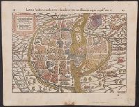
Appears in the author's Cosmographia., Bird's-eye view., In top margin: 88 ... 89., Includes text, "90 ... 87" on verso., Latin., Oriented with north to the left., Relief shown pictorially., and Signatures: g3 [on recto], g2 [on verso].
Publisher:
Heinrich Petri,
Subject (Geographic):
Paris (France)--Aerial views--Early works to 1800 and Paris (France)--Maps--Early works to 1800
Subject (Name):
Manuel, Hans Rudolf, 1525-1571 and Petri, Heinrich, 1508-1579
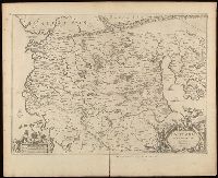
No. 13 of 69 maps bound together in composite atlas., Oriented with north towards upper left., Relief shown pictorially., Scale not given., and Title in Latin; place names in French.
Relief shown pictorially., Verso blank., and Watermark. Manuscript number in upper left corner: 27. Manuscript annotations below neat line.
Publisher:
[Jan Jansson],
Subject (Geographic):
Albania, Albania--Maps--Early works to 1800., Europe--Macedonia, Greece--Maps--Early works to 1800., Macedonia (Republic)--Maps--Early works to 1800., and Macedonia--Maps--Early works to 1800.
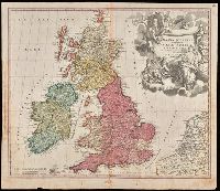
"Cum privilegio S.C.M.", Appeared in Homann's Atlas Novus Terrarum., Prime meridian: Ferro., Relief shown pictorially., Variant with portrait of George I in armour in the cartouche, Plymouth, England spelled correctly, and Delft, Netherlands misspelled "Dolft.", and Watermark. Manuscript number in upper right corner. From the Karpinski-von Wieser Map Collection.
Publisher:
[Johann Baptist Homann]
Subject (Geographic):
British Isles--Maps--Early works to 1800. and Europe--British Isles
Subject (Name):
Homann Erben (Firm) and Homann, Johann Baptist, 1663-1724. Atlas novus terrarum
Homann Erben (Firm) Homann, Johann Baptist, 1663-1724
Published / Created:
1729
Call Number:
1975 Folio 31
Collection Title:
[Atlas factice of 42 maps, produced by the Homann Erben firm]
Image Count:
1
Alternative Title:
General map of Great Britain and Ireland with part of Holland, Flanders France &c. agreable to modern history by the heirs of late Mr. Homann at Nuremburg, priviledged by Emperours Majesty
Publisher:
Homann Erben
Subject (Geographic):
Great Britain --Maps --Early works to 1800 and Ireland --Maps --Early works to 1800
Homann Erben (Firm) Homann, Johann Baptist, 1663-1724
Published / Created:
ca. 1730]
Call Number:
319 1720
Container / Volume:
BRBL_00040
Image Count:
1
Resource Type:
Maps, Atlases & Globes
Alternative Title:
General map of Great Britain and Ireland with part of Holland, Flanders France &c. agreable to modern history by the heirs of late Mr. Homann at Nuremburg
Description:
Graphic scales given in "mill. Anglica" and "milliaria Germ.", Inset, top right: Orcades insulae ... Schetlandicae., Ornate title cartouche, top left, depicting coat of arms and flags., Relief shown pictorially., and Sheet measures 54.5 x 61.9 cm.
Publisher:
Homann Erben,
Subject (Geographic):
Great Britain--Maps--Early works to 1800 and Ireland--Maps--Early works to 1800
Homann Erben (Firm) Homann, Johann Baptist, 1663-1724
Published / Created:
[ca. 1730]
Call Number:
1983 Folio 23
Collection Title:
[Atlas factice of 50 maps, primarily by Johann Baptist Homann and/or issued by the Homann Erben
Image Count:
1
Alternative Title:
General map of Great Britain and Ireland with part of Holland, Flanders France &c. agreable to modern history by the heirs of late Mr. Homann at Nuremburg
Publisher:
[Homann Erben]
Subject (Geographic):
Great Britain --Maps --Early works to 1800 and Ireland --Maps --Early works to 1800
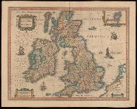
Bar scales given in "milliaria Anglica communia," "milliaria Anglica parva," and "milliaria Germanica communia.", From Joan Blaeu's Latin edition of Theatrum orbis terrarum (1648)., In Latin on verso, with caption title "Britannia," signature A, and paginated 1-2., Relief shown pictorially., Watermark., and With inset map "Orcades insulae."
Subject (Geographic):
Great Britain--Maps--Early works to 1800.
Subject (Name):
Blaeu, Joan, 1596-1673 and Blaeu, Joan, 1596-1673. Theatrum orbis terrarum.