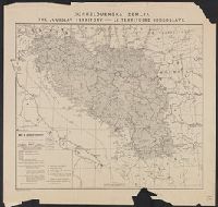
Jugoslav territory, Jugoslovenska zemlja, Map of southern Slav territory, and Territoire Iougoslave
Description:
"Issued for the Jugoslav Committee in London.", "September, 1917, London.", Includes "Jugoslav orthography.", and Legend in English, Croatian, and French.
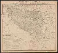
Jugoslav territory, Jugoslovenska zemlja, Map of southern Slav territory, and Territoire Iougoslave
Description:
"Issued for the Jugoslav Committee in London.", "September, 1915, London.", In upper margin: "Jugoslovenska zemlja, the Jugoslav territory, le territoire Iougoslave.", Includes "Jugoslav orthography.", and Legend in English, Croatian, and French.
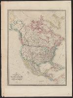
Appears in Wyld's New general atlas. London, 1854. Cf. Phillips, Maps of America, p. 607., In upper right margin: 36., Relief shown by hachures., and Yale's copy stamped on verso: Yale University Library, Karpinski-Von Wieser Map Collection.
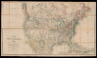
Date beneath publisher statement: March 1st 1827., Includes notes., Relief shown by hachures., Some sheets: Published by Jas. Wyld (successor to W. Faden, and Stevens and Tree describe the various issues of this map in Tooley's Mapping of America, p. 91., no. 63.
Includes inscription to "John Manners.", Relief shown pictorially and by hachures. Depths shown by soundings., and Shows administrative boundaries on St. John's Island.
Publisher:
Printed & sold by A. Dury,
Subject (Geographic):
Cape Breton Island (N.S.)--Maps--Early works to 1800, Nova Scotia--Maps--Early works, Prince Edward Island--Administrative and political divisions--Maps--Early works to 1800, and Prince Edward Island--Maps--Early works to 1800
Inset map of England and Wales on same scale., Issued, Map shows major methods of communication and transportation., Map text and explanation in Spanish and English., and On verso: 37p. description of the country with statistical information by Eduardo Higginson.