The description of this slide reflects the way that Erdoes organized 35mm slides. Erdoes arranged his slides in labeled containers that were sub-divided into labeled sections. The title for this image has been transcribed from its sub-section label; images of other slides from the same sub-section share the container title. The date listed here reflects a span of known dates associated the sub-section. In some cases, titles have been expanded to note particular individuals who appear frequently and who were identified by Erdoes in captions. Individual slide captions have not been transcribed or captured during digitization.
Subject (Geographic):
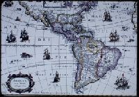
North America--Maps--Early works to 1800 and South America--Maps--Early works to 1800
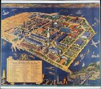
San Francisco Bay Exposition Company White, Ruth Taylor
Published / Created:
c1939
Call Number:
BrSides Zc72 939wh
Image Count:
1
Abstract:
An aerial panorama of the exposition grounds, with a portion of San Francisco in the foreground and whimsical sea monsters, whales, and boats in the water around the island.
Alternative Title:
Golden Gate International Exposition
Publisher:
San Francisco Bay Exposition
Subject (Geographic):
Oakland (Calif.), San Francisco (Calif.), and San Francisco-Oakland Bay Bridge (Oakland and San Francisco, Calif.)
Subject (Name):
Golden Gate International Exposition (1939-1940 : San Francisco, Calif.)
Delaware --Maps --Early works to 1800, New Jersey --Maps --Early works to 1800, New York (State) --Maps --Early works to 1800, and Pennsylvania --Maps --Early works to 1800
Subject (Name):
Mifflin, Thomas, 1744-1800 and Wallis, John, 1734-1793
Subject (Topic):
Canals --Pennsylvania --Maps --Early works to 1800 and Roads --Pennsylvania --Maps --Early works to 1800
The diaries describe an 1849 expedition by way of St. Joseph, Fort Kearney, Fort Laramie, South Pass, Sublette's Cut-off, Bear River, Cantonment Loring, Raft River, the Humboldt, Lassen's Route to Deer Creek, and Bruff's camp. They contain maps and sketches from the journey and notes on life in California. The journals were written from the diaries. The notebooks contain more sketches from the trip and of equipment. There are memoranda of supplies and equipment, routes, and remedies.
Alternative Title:
Emmigration, across the continent, in 1849, to
Subject (Geographic):
California --Description and travel, West (U.S.) --Description and travel, West (U.S.) --Maps, and West (U.S.) --Pictorial works
Subject (Name):
Bruff, Joseph Goldsborough, 1804-1889 and Washington City and California Mining Association
Subject (Topic):
Gold mines and mining --California --History --19th century --Personal narratives, Gold mines and mining --North America --History --19th century, Gold mines and mining --Sierra Nevada (Calif. and Nev.), Gold mines and mining --United States --History, and Gold mines and mining --West (U.S.) --History --19th century
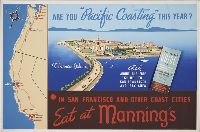
At-a-glance guide to San Francisco and the bay area, Eat at Mannings, and In San Francisco and other coast cities, eat at Mannings.
Description:
Affixed to poster is a folded brochure, measuring 22 x 10 cm., with title: At-a-glance guide to San Francisco and the bay area with direct routes to the Golden Gate International Exposition, California Worlds Fair, on Treasure Island, 1939 / compliments o
Publisher:
Velvetone
Subject (Geographic):
Pacific Coast (U.S.) and San Francisco (Calif.)
Subject (Name):
Golden Gate International Exposition (1939-1940 : San Francisco, Calif.)
Subject (Topic):
Advertisements, Architecture, Boats and boating, Exhibition buildings, and World's fairs
[Atlas factice of 96 maps by Blaeu, Visscher, Jansson, Hondius and others]
Image Count:
2
Resource Type:
Maps, Atlases & Globes
Description:
All four sides of map decorated with city views and costumed figures of different social classes. Includes coats of arms., Imperfect: torn along fold, with some loss of text; portions of decorative border cut or torn and repaired, with missing sections replicated in ms.; tears repaired., and No. 5 of 92 maps bound together.
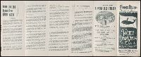
Pacific Steam Whaling Co.: Sailing dates of steamers, Pacific Steam Whaling Company’s map of Alaska. 1897, and Sitka and Ounalaska U.S.mail route …
Description:
Accompanying page entitled "Sitka and Ounalaska U.S.mail route …", In pencil on verso (folded): Beinecke / Library / Zc86 / 897cq., In pencil on verso (folded): Source unknown., Recto has 12 sections containing illustrations, text and 1 map., Verso has 1 large color map entitled "Pacific Steam Whaling Company’s map of Alaska"., and Yale proprietary stamp on lower right corner of map.
Publisher:
Schmidt L. & L. Co
Subject (Geographic):
Alaska --Description and travel, Copper River Region (Alaska), Klondike River Valley (Yukon) --Gold discoveries, Prince William Sound (Alaska), Valdez (Alaska), and Yukon Territory
Subject (Name):
Pacific Steam Whaling Company
Subject (Topic):
Gold mines and mining --Alaska and Indians of North America --Alaska