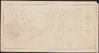
In bottom margin: Photolithographed preliminary sheet for the use of the parties in the field and subject to revision., In top margin: Northe, Library's copy separated into two sheets (59 x 58 cm. and 59 x 55 cm.)., and Relief shown by contours and spot heights.
Publisher:
Northern Transcontinental Survey?],
Subject (Geographic):
Judith River Watershed (Mont.)--Maps, Topographic
Subject (Name):
Julius Bien & Co, Northern Transcontinental Survey. Topographical Dept, and Owen, F. D
Map of Yakima Region, Washington Ter., western sheet
Description:
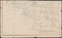
"Photolithographed preliminary sheet for the use of the parties in the field, and subject to revision.", In top margin: Western sheet., and Relief shown by contours and spot heights.
Publisher:
Northern Transcontinental Survey?],
Subject (Geographic):
Yakima River Valley (Wash.)--Maps, Topographic
Subject (Name):
Goode, Richard Urquhart, 1858-1903, Julius Bien & Co, Northern Transcontinental Survey, Owen, F. D, and Tweedy, Frank, 1854-1937
Map of Yakima Region, Washington Ter., eastern sheet
Description:
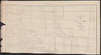
"Photolithographed preliminary sheet for the use of the parties in the field, and subject to revision.", "There is a slight discordance in projecting the U.S. Land Survey upon this map. A part of the S.W. corner is taken from the U.S. Land Office plats.", and n top margin: Eastern sheet.
Publisher:
Northern Transcontinental Survey?],
Subject (Geographic):
Yakima River Valley (Wash.)--Maps, Topographic
Subject (Name):
Goode, Richard Urquhart, 1858-1903, Julius Bien & Co, Northern Transcontinental Survey, Owen, F. D, and Tweedy, Frank, 1854-1937