Skip to search
Skip to main content
Skip to first result
Search
You Searched For
Genre
Engravings
Genre
Maps in books
New Search
Search Results
Call Number:
1977 +392
Collection Title:
A survey of the cities of London and Westminster : containing the original, antiquity, increase
Image Count:
1
Resource Type:
Maps, Atlases & Globes
Description:
Plate between p. 44-45.
Subject (Geographic):
London (England)--History
Collection Created:
London : Printed for A. Churchill, J. Knapton, R. Knaplock, J. Walthoe [and 6 others], 1720
Found in:
Beinecke Rare Book and Manuscript Library > The parish of St. Johns Wapping
Creator:
Published / Created:
1772 March 2
Call Number:
1982 Folio 10
Image Count:
1
Description:
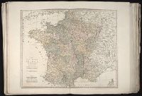
Also appeared in Kitchin's General atlas describing the whole universe. London : Printed Robert Sayer and J. Bennet, 1773; and General atlas describing the whole universe. London : Printed and sold for R. Sayer and J. Bennet, 1780., Ferro meridian., France divided into regions., From the map of Jaillot., No. 12 of 43 maps bound together in composite atlas., Relief shown pictorially., Scale [1:2,250,000]., and Shows boundaries, rivers, roads with distances and settlements.
Publisher:
Printed for Rob. Sayer
Subject (Geographic):
France --Maps --Early works to 1800
Found in:
Beinecke Rare Book and Manuscript Library > The post roads of France
Call Number:
1976 1233
Collection Title:
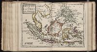
Forty-two new maps of Asia, Africa, and America ... : all engrav’d, according to the latest
Image Count:
1
Alternative Title:
The principal islands in the East Indies
Description:
In ink on verso: 11.
Subject (Geographic):
Borneo --Maps, East Indies --Maps --Early works to 1800, and Philippines --Maps --Early works to 1800
Subject (Name):
Nicholson, John, d. ca. 1717, bookseller
Subject (Topic):
Atlases --Early works to 1800
Collection Created:
London : Printed for J. Nicholson ..., 1716 ...
Found in:
Beinecke Rare Book and Manuscript Library > The principal islands of the East Indies, according to ye newest observations
Creator:
Published / Created:
[1696]
Call Number:
1973 Folio 10
Image Count:
1
Resource Type:
Maps, Atlases & Globes
Alternative Title:
Principal islands in America belonging to the English empire viz Jamaica, Barbados, Antegoa, St. Christophers & Bermudos
Description:
[Antigua and Bermuda Islands] -- A general map of the Cariby Islands -- [Saint Kitts] -- [Barbados] -- The explanation of the marks on the island of Iamaica., Bar scale given in miles., No. 62 of 69 maps bound together in composite atlas., Relief shown pictorially., and Scales differ.
Publisher:
Sold by Phillip Lea at the Atlas and Hercules in Cheapside
Subject (Geographic):
West Indies --Maps --Early works to 1800
Found in:
Beinecke Rare Book and Manuscript Library > The principall islands in America belonging to the English empire viz Iamaica, Barbados, Antegoa, St. Christophers [and] Bermudos
Creator:
Call Number:
1976 Folio 110
Collection Title:
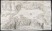
The mariners mirrovr wherin may playnly be seen the courses, heights, distances, depths, sounding
Image Count:
1
Resource Type:
Maps, Atlases & Globes
Subject (Geographic):
Dover (England), England, English Channel, and Isle of Wight (England)
Collection Created:
[London, J. Charlewood? 1588]
Found in:
Beinecke Rare Book and Manuscript Library > The sea coastes of England betweene the Ile of Wight & Douer, with the principal hauens thereof according to their situation and appearing
Creator:
Call Number:
1976 Folio 110
Collection Title:
The mariners mirrovr wherin may playnly be seen the courses, heights, distances, depths, sounding
Image Count:
1
Resource Type:
Maps, Atlases & Globes
Subject (Geographic):
Bristol Channel, England, and English Channel
Collection Created:
[London, J. Charlewood? 1588]
Found in:
Beinecke Rare Book and Manuscript Library > The sea coastes of England, from the Sorlinges by the landes end to Plymouth with the hauens and harbrowghes
Creator:
Call Number:
1976 Folio 110
Collection Title:
The mariners mirrovr wherin may playnly be seen the courses, heights, distances, depths, sounding
Image Count:
1
Resource Type:
Maps, Atlases & Globes
Description:
Theodor de Bry, Sculp.
Subject (Geographic):
Bordeaux (France) and Garonne River (Spain and France)
Collection Created:
[London, J. Charlewood? 1588]
Found in:
Beinecke Rare Book and Manuscript Library > The sea coastes of the landes of Poyctou and Bordeaux ...as they shew and appeare, when you sayle there alongst betweene Picquelier and the River of Bordeaux called the Garonne
Branch:v1.61.6 ,Deployed:2024-06-12T09:55:37-04:00