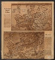
Includes ill. maps and text: "Printed about 1915 ... what would happen if the Allies won, a fearsome propaganda picture for the common German soldier ... were contained in an envelope which said The Map of Europe, how our enemies want to shape it and how
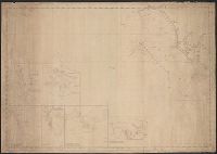
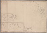
Engraved & Printed gy W.Hooker, New York. and Insets: Cape Fear River from its entrance to Smithville. Cape Fear, Cape Lookout. The Bar & Roads of Occracock.
Insets: Cape Fear River, from its entrance to Smithville. Scale [ca. 1:60,000] -- Beaufort harbour. Scale [ca. 1:40,000] -- The bar & roads of Occracock [sic]. Scale [ca. 1:100,000] -- Cape Hatteras. Scale [ca. 1:110,000] -- Cape Lookout. Scale [ca. 1:275
Publisher:
E. & G.W. Blunt,
Subject (Geographic):
Atlantic Coast (N.C.)--Maps., Beaufort (N.C.)--Maps., Cape Fear River Estuary (N.C.)--Maps., Fear, Cape (N.C.)--Maps., Hatteras, Cape (N.C.)--Maps., Lookout, Cape (N.C.)--Maps., and North Carol