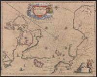
Nova et accvrata Poli Arctici et terrarum circum Iacentium descriptio
Description:
Cross collection no. 51., From: Nouvel atlas, ou, Theatre du Monde ... Amstelodami : Apud Ioannem Ianssonium, 1649., In Latin, with French text on verso; running title "Description"; caption title "Le pole Arctique avec les regions situees dessous"; sig. P., and Includes ill. and decorative cartouche.
Publisher:
Apud Ioannem Ianssonium,
Subject (Geographic):
Arctic Regions--Maps--Early works to 1800
Subject (Name):
Jansson, Jan, 1588-1664. Nouvel atlas, ou, theatre du monde
Appears in French editions of Jansson's and Hondius's Atlas n, French text on verso, with signature 5d., Hand col. Sheet measures 47.5 x 57 cm., Relief shown pictorially., and Stamp on verso: Yale University Library Karpinski-von Wieser Map Collection.
Publisher:
Johannes Janssonius excudit,
Subject (Geographic):
Atlantic States--Maps--Early works to 1800 and Maritime Provinces--Maps--Early works to 1800
Subject (Name):
Hondius, Hendrik, 1597-1651. Atlas novus. French and Jansson, Jan, 1588-1664. Atlas novus. French
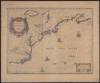
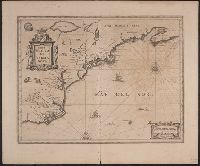
From Jansson's Atlas major ... Amstelodami : Apud Johannis Janssonij Haeredes, [1675]., Hand col. Sheet measures 50.8 x 60 cm. Initial on verso hand-colored. Cross Collection no. 180., Ill. of animals and Indian village., Latin text on verso, with no signature., and Relief shown pictorially.
Publisher:
Johannes Janssonius excudit,
Subject (Geographic):
Atlantic States--Maps--Early works to 1800 and Maritime Provinces--Maps--Early works to 1800
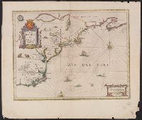
Appears in Dutch editions of Jansson's Atlas novus., Dutch text on verso, with catchword "West-Indien" and signature 2C., Hand col. Sheet measures 50 x 60.5 cm., Ill. of animals and Indian village., and Relief shown pictorially.
Publisher:
Johannes Janssonius excudit,
Subject (Geographic):
Atlantic States--Maps--Early works to 1800 and Maritime Provinces--Maps--Early works to 1800
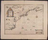
Appears in Latin editions of Jansson's Atlas novus., Ill. of animals, Indian village., Latin text on verso with catchword "America" and signature 3C., and Sheet measures 49.5 x 59 cm. Stamp on verso: Yale Horace Brown 1900S.
Publisher:
Johannes Janssonius excudit,
Subject (Geographic):
Atlantic States--Maps--Early works to 1800 and Maritime Provinces--Maps--Early works to 1800
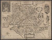
French text on verso, with running and caption title "Virginie," signature e, and catchword "ses.", From Jan Jansson's Nouvel atlas ... Amstelodami : Apud Ioannem Ianssonium, 1646-1649., Hendrik Hondius' derivative of John Smith's map of Virginia, 1612., and Ori
Publisher:
Ex officina Henrici Hondii,
Subject (Geographic):
Chesapeake Bay (Md. and Va.)--Maps--Early works to 1800, Maryland--Maps--Early works to 1800, and Virginia--Maps--Early works to 1800
Subject (Name):
Jansson, Jan, 1588-1664. Atlas novus. French and Smith, John, 1580-1631
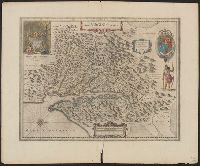
Dutch text on verso, with running and caption title "Virginia," signature 2D, and catchword "riviere.", Hendrik Hondius' derivative of John Smith's map of Virginia, 1612., Oriented with north toward the right., Relief shown pictorially., and Royal arms in upper r
Publisher:
Ex officina Henrici Hondii,
Subject (Geographic):
Chesapeake Bay (Md. and Va.)--Maps--Early works to 1800, Maryland--Maps--Early works to 1800, and Virginia--Maps--Early works to 1800
Subject (Name):
Jansson, Jan, 1588-1664. Atlas novus. Dutch and Smith, John, 1580-1631