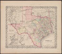
"No.35" and "No.36.", Includes Frio and Zavala counties which were formed in 1858 and which do not appear on Colton map dated 1857., Insets: Plan of the northern part of Te, and Library's copy annotated in pencil "This is in the same state as in the 1859 atlas."
Publisher:
Johnson & Browning,
Subject (Geographic):
Texas Panhandle (Tex.)--Maps, Texas--Administrative and political divisions--Maps, and Texas--Maps
Subject (Name):
De Cordova, Jacob, 1808-1868, J.H. Colton & Co, Johnson & Browning, and Streeter, Thomas W.--(Thomas Winthrop),--1883-1965--Ownership
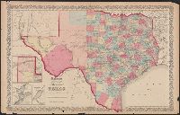
"Entered according to act of Congress in the year 1855 by J.H. Colton & Co. in the clerks office of the district court of the United States for the southern district of New York.", "No. 35.", Prime meridians: Greenwich and Washington., Relief, and Shows counties.
Publisher:
J.H. Colton & Co.,
Subject (Geographic):
Texas--Administrative and political divisions--Maps and Texas--Maps
Subject (Name):
Streeter, Thomas W.--(Thomas Winthrop),--1883-1965--Ownership