
You Searched For
1 - 6 of 6
Search Results
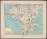
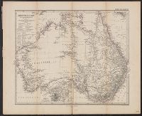
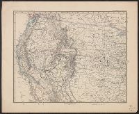
- Creator:
- H. Alt & Schröder, engravers
Justus Perthes (Firm : Gotha, Germany), publisher
Petermann, A. (August Heinrich), 1822-1878
Stieler, Adolf, 1775-1836. Stieler's Hand-Atlas - Published / Created:
- [1883?]
- Call Number:
- 26 1883
- Container / Volume:
- BRBL_00022
- Image Count:
- 1
- Resource Type:
- Maps, Atlases & Globes
- Description:
- In German., In lower left margin: Rev. 1883., Map of Australia showing explorers' tracks, railways and telegraph lines. Relief shown by hachures and spot heights., Pr, and Sheet measures 40.5 x 49 cm. Verso: Stamped "Karpinski-von Wieser Map Collection".
- Publisher:
- Justus Perthes,
- Subject (Geographic):
- Australia--Discovery and exploration--Maps and Australia--Maps
- Subject (Topic):
- Railroads--Australia--Maps
- Found in:
- Beinecke Rare Book and Manuscript Library > Australien / von A. Petermann ; gestochen von H. Alt & Schröder.
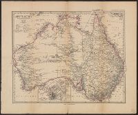
- Creator:
- H. Alt & Schröder, engravers
Justus Perthes (Firm : Gotha, Germany), publisher
Petermann, A. (August Heinrich), 1822-1878
Stieler, Adolf, 1775-1836. Stieler's Hand-Atlas - Published / Created:
- [1873?]
- Call Number:
- 26 1873
- Container / Volume:
- BRBL_00022
- Image Count:
- 1
- Resource Type:
- Maps, Atlases & Globes
- Description:
- Imperfect, In German., In lower right margin: Gestochen von H. Alt & Schröder., Map of Australia showing explorers' tracks and railways. Relief shown by hachures and spot heights., and Plate no. 73 from: Stieler's Hand-Atlas. Gotha : J. Perthes, [1873?]
- Publisher:
- Justus Perthes,
- Subject (Geographic):
- Australia--Discovery and exploration--Maps and Australia--Maps
- Subject (Topic):
- Railroads--Australia--Maps
- Found in:
- Beinecke Rare Book and Manuscript Library > Australien / von A. Petermann.
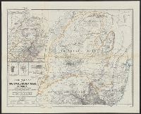
- Creator:
- Petermann, A. (August Heinrich), 1822-1878
- Published / Created:
- 1868
- Call Number:
- 643 1868
- Container / Volume:
- BRBL_00339
- Image Count:
- 1
- Resource Type:
- Maps, Atlases & Globes
- Alternative Title:
- Ergänzungsheft ... zu Petermanns geographischen Mitteilungen. and Transvaal or South-African Republik
- Description:
- "From surveys and observations by Survr. Genl. M. Forssmann, C. Mauch, F. Hammar, Survr. J. Brooks, and other official documents, combined with the results of their own explorations by F. Jeppe and A. Merensky, Potchefstroom & Botsabelo, 1868." and In top mar
- Publisher:
- Justus Perthes ,
- Subject (Geographic):
- South Africa--Maps and Swaziland--Maps
- Subject (Name):
- Justus Perthes (Firm : Gotha, Germany)
- Found in:
- Beinecke Rare Book and Manuscript Library > Original map of the Transvaal or South-African Republik / reconstructed and augmented with data from various exploring travellers &c. by A. Petermann.
5.
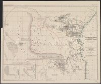
- Creator:
- Petermann, A. (August Heinrich), 1822-1878
- Published / Created:
- 1856
- Call Number:
- 63 1856
- Container / Volume:
- BRBL_00334
- Image Count:
- 1
- Resource Type:
- Maps, Atlases & Globes
- Alternative Title:
- Ost-u.-Central-Afrika and Petermanns geographische Mittheilungen.
- Description:
- "Gestützt auf die Angaben zahlreicher Eingebornen und muhamedanischer Reisenden und zusammengetragen von Jakob Erhardt u, In top margin: Petermann's geographische Mittheilungen, Jahrgang 1856, Tafel 1., Includes 2 insets and text., and Relief shown by hachures.
- Publisher:
- Justus Perthes ,
- Subject (Geographic):
- Africa, East--Maps
- Subject (Name):
- Erhardt, Jakob, Justus Perthes (Firm : Gotha, Germany), and Rebmann, Johann
- Subject (Topic):
- Caravans--Africa, East--Maps
- Found in:
- Beinecke Rare Book and Manuscript Library > Skizze einer Karte eines Theils von Ost-u. Central-Afrika, mit Angabe der wahrscheinlichen Lage u. Ausdehnung des See's von Uniamesi, nebst Bezeichnung der Grenzen u. Wohnsitze der verschiedenen Völker, sowie der Caravanen-Strassen nach dem Innern / nach
- Creator:
- Petermann, A. (August Heinrich), 1822-1878
- Published / Created:
- 1879
- Call Number:
- 75 1879A
- Container / Volume:
- BRBL_00407
- Image Count:
- 2
- Resource Type:
- Maps, Atlases & Globes
- Alternative Title:
- Stieler's Hand Atlas
- Description:
- "Stieler's Hand Atlas, No. 79 ; Stieler's Hand Atlas, No. 80.", Imperfect: sheet 3-4 wanting., Inset: Atlantischen Staaten zwischen Washington & Boston, 1:2,000,000., Prime meridian: Greenwich., and Relief shown by hachures.
- Publisher:
- Justus Perthes,
- Subject (Geographic):
- United States--Maps
- Subject (Name):
- Habenicht, Hermann, 1844-1917 and Justus Perthes (Firm : Gotha, Germany)
- Found in:
- Beinecke Rare Book and Manuscript Library > West-Indien in 4 Blättern / [A.] Petermann ; bearbeitet von H. Habenicht.