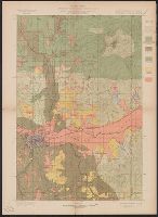
"Engraved Apr. 1901 by Julius Bien & Co.", "Surveyed in 1897-98.", Plate CXXXIII from the "Twenty-first annual report" of the U.S. Geological Survey, Part 5, Forest reserves (1900)., Relief shown by contours and spot heights., and Shows five classes of land cover.
Publisher:
The Survey,
Subject (Geographic):
Chelan County (Wash.)--Maps and Douglas County (Wash.)--Maps
Subject (Name):
Farmer, R. A, Geological Survey (U.S.). Annual report, Griswold, W. T, and Plummer, Fred G. (Fred Gordon), 1864-1913
Subject (Topic):
Forests and forestry--Washington (State)--Chelan County--Maps, Forests and forestry--Washington (State)--Douglas County--Maps, Forests and forestry--Washington (State)--Okanogan County--Maps, and Land capability for agricultur
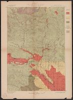
"Julius Bien & Co. Lith. N.Y.", "Surveyed in 1899.", Plate CXXXII from the "Twenty-first annual report" of the U.S. Geological Survey, Part 5, Forest reserves (1900)., Relief shown by contours and spot heights., and Shows five classes of land cover.
Publisher:
The Survey,
Subject (Geographic):
Yakima County (Wash.)--Maps
Subject (Name):
Geological Survey (U.S.). Annual report, Murlin, A. E, and Plummer, Fred G. (Fred Gordon), 1864-1913
Subject (Topic):
Forests and forestry--Washington (State)--Kittitas County--Maps, Forests and forestry--Washington (State)--Yakima County--Maps, Kittitas County (Wash.)--Maps, and Land capability for agriculture--Washington (State)--Kittitas C
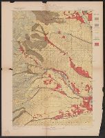
"Julius Bien & Co. Lith. N.Y.", "Surveyed in 1896-97.", Plate CXXXI from the "Twenty-first annual report" of the U.S. Geological Survey, Part 5, Forests reserves (1900)., Relief shown by contours and spot heights., and Shows five classes of land cover.
Publisher:
The Survey,
Subject (Geographic):
Chelan County (Wash.)--Maps, Kittitas County (Wash.)--Maps, and Wenatchee National Forest (Wash.)--Maps
Subject (Name):
Geological Survey (U.S.). Annual report and Plummer, Fred G. (Fred Gordon), 1864-1913
Subject (Topic):
Forests and forestry--Washington (State)--Chelan County--Maps, Forests and forestry--Washington (State)--Kittitas County--Maps, and Land capability for agriculture--Washington (State)--Kittitas County--Maps
"Engraved April 1901 by Julius Bien & Co., "Surveyed in 1898.", Plate CXXXIV from the "Twenty-first annual report" of the U.S. Geological Survey, Part 5, Forest reserves (1900)., Relief shown by contours and spot heights., and Shows six classes of land cover.
Publisher:
The Survey,
Subject (Geographic):
Spokane County (Wash.)--Maps
Subject (Name):
Geological Survey (U.S.). Annual report, Manning, Van H, and Plummer, Fred G. (Fred Gordon), 1864-1913
Subject (Topic):
Forests and forestry--Washington (State)--Spokane County--Maps and Land capability for agriculture--Washington (State)--Spokane County--Maps