
You Searched For
« Previous
| 41 - 50 of 50 |
Next »
Search Results


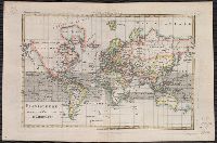
- Creator:
- Lowitz, G. M. (George Moritz), 1722-1774
- Published / Created:
- 1746
- Call Number:
- 11 1746A
- Container / Volume:
- BRBL_00681
- Image Count:
- 1
- Resource Type:
- Maps, Atlases & Globes
- Alternative Title:
- Mappe-monde qui représente les deux hemisphères savoir celui de l'orient et celui de l'occident, tirée des quatre cartes générales de feu M. le profess. Hasius, Planiglobii terrestris mappa vniversalis, and Schul-Atlas von zwantzig General- und Special-Lan
- Description:
- Appears in Homann heirs' Schul-atlas von zwantzig general-und special-land karten ... Cf. Phillips, no. 293., Imperfect: torn along fold, with no loss of text. Shee, Map colored to show distribution of religions., and Title in Latin and French; legend in German.
- Publisher:
- Homann Erben],
- Subject (Name):
- Hase, Johann Matthias, 1684-1742 and Homann Erben (Firm)
- Subject (Topic):
- Religion--Maps--Early works to 1800 and World maps--Early works to 1800
- Found in:
- Beinecke Rare Book and Manuscript Library > Planiglobii terrestris mappa universalis utrumq[ue] hemisphaerium orient. et occidentale repraesentans, ex IV. mappis generalibus, Hasianis composita et adjectis ceteris hemisphaeriis / designata a G.M. Lowizio ; excudentibus Homann. Heredibus = Mappe-mon
- Creator:
- Bonne, Rigobert, 1727-1794
- Published / Created:
- 1780?]
- Call Number:
- 11 1780
- Container / Volume:
- BRBL_00722
- Image Count:
- 1
- Resource Type:
- Maps, Atlases & Globes
- Description:
- From Bonne's Atlas de toutes les parties connues du globe terrestre ... [Paris : J.L. Pellet, 1780?]., Hand col. Sheet measures 26 x 39 cm. Verso: "Projection de Mercator" in ink ms. Lada-Mocarski Collection., Meridians: Ferro, Paris., and Top left, in margin: "
- Publisher:
- J.L. Pellet,
- Subject (Name):
- Bonne, Rigobert, 1727-1794. Atlas de toutes les parties connues du globe terrestre .. and Pellet, J.-L. (Jean-Léonard), publisher
- Subject (Topic):
- Cartographers--France--18th century and World maps--Early works to 1800
- Found in:
- Beinecke Rare Book and Manuscript Library > Planisphere suivant la projection de Mercator.

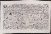
- Creator:
- Münster, Sebastian, 1489-1552
- Published / Created:
- [1532]
- Call Number:
- 11 1509A
- Image Count:
- 1
- Resource Type:
- Maps, Atlases & Globes
- Abstract:
- Decorated with sea monsters, mermaids, exotic animals, and cannibals, this wood cut map provides a marked contrast to the simplistic diagrams considered the earliest printed world maps. While the latter presented a world view based in Judeo-Christian theo
- Alternative Title:
- Typus cosmographicus universalis and Typvs cosmographicvs vniversalis
- Description:
- Appears in Johann Huttich's Novus orbis regionum. Basel. 1532. and Relief shown pictorially.
- Publisher:
- [publisher not identified],
- Subject (Name):
- Holbein, Hans, 1497-1543 and Huttich, Johann, 1480?-1544. Novus orbis regionum.
- Subject (Topic):
- World maps--Early works to 1800
- Found in:
- Beinecke Rare Book and Manuscript Library > Typus cosmographicus uniuersalis.

- Creator:
- Münster, Sebastian, 1489-1552
Petri, Heinrich, 1508-1579
Ptolemy, 2nd cent - Published / Created:
- 1545?]
- Call Number:
- 11 1545
- Image Count:
- 1
- Resource Type:
- Maps, Atlases & Globes
- Alternative Title:
- Typvs vniversalis, anno 1545
- Description:
- Possibly from Münster's 1545 edition of Ptolemy's Geographia [Basel : Heinrich Petri, 1545]. and Sheet measures 31.5 x 39 cm. Stamp on verso: Karpinski-von Wieser Map Collection.
- Publisher:
- Heinrich Petri,
- Subject (Topic):
- World maps--Early works to 1800
- Found in:
- Beinecke Rare Book and Manuscript Library > Typus universalis, anno 1545 [cartographic material].
46.
- Creator:
- Bertelli, Donato
- Published / Created:
- 1568
- Call Number:
- 11 1568
- Container / Volume:
- BRBL_00732
- Image Count:
- 1
- Resource Type:
- Maps, Atlases & Globes
- Alternative Title:
- Vniversale descrittione di tvtta la terra conoscivta fin qvi
- Description:
- From: [Italian composite atlases]., Map is made from a new copper plate which is a close copy of Paolo Forlani's world map, which Forlani copied from Giacomo Gastaldi's prototype world map of 1546., Relief shown pictorially., and There are winged cherub heads in the top two spandrels.
- Publisher:
- Donato Bertelli,
- Subject (Name):
- Forlani, Paolo and Gastaldi, Giacomo, ca. 1500-ca. 1565
- Subject (Topic):
- World maps--Early works to 1800
- Found in:
- Beinecke Rare Book and Manuscript Library > Universale descrittione di tutta la terra conosciuta fin qui / in Venetia alla libraria del segno del S. Marco in Merzaria, D.B., MDLXVIII.
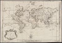
- Creator:
- Bellin, Jacques Nicolas, 1703-1772
- Published / Created:
- 1748
- Call Number:
- 11 1748
- Container / Volume:
- BRBL_00681
- Image Count:
- 1
- Resource Type:
- Maps, Atlases & Globes
- Description:
- Cross collection no. 40., In lower right corner: "Tom VII No. 22.", Prime meridian: Paris., Relief shown pictorially., and Scale measured at center of hemisphere.
- Publisher:
- s.n.],
- Subject (Name):
- Maurepas, Jean-Frédéric Phélypeaux, comte de, 1701-1781
- Subject (Topic):
- World maps--Early works to 1800
- Found in:
- Beinecke Rare Book and Manuscript Library > Versuch von einer Kurzgefassten Karte welche die bekannten Theile der Erdkugel / [cartographic material] / enthaelt dem Hm. grafen von Maurepas ; zugeeignet von N. Bellin.
48.
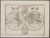
- Creator:
- Tirion, Isaak
- Published / Created:
- 1744
- Call Number:
- 11 1744A
- Container / Volume:
- BRBL_00681
- Image Count:
- 1
- Resource Type:
- Maps, Atlases & Globes
- Description:
- "C. Sepp del. et sculps. 1744.", Cross collection no. 37., In Dutch., Includes 2 smaller circular polar maps, and decorative cartouche., Mounted on linen., Ms. note at head of map: No. J., Relief shown pictorially., and Scale measured at center of hemisphere.
- Publisher:
- [Isaak Tirion],
- Subject (Name):
- Sepp, Christiaan, d. 1775
- Subject (Topic):
- World maps--Early works to 1800
- Found in:
- Beinecke Rare Book and Manuscript Library > Wereld kaart [cartographic material] : na de alderlaatste ontdekking in't licht gebragt / by Isaak Tirion.
49.

- Creator:
- Ribero, Diego, d. 1533
- Published / Created:
- 1900?]
- Call Number:
- 11 1529
- Image Count:
- 2
- Resource Type:
- Maps, Atlases & Globes
- Description:
- Copy 2: Col. Preliminary record. and Reprint of original at the Vatican Library.
- Publisher:
- W. Griggs,
- Subject (Topic):
- World maps--Early works to 1800
- Found in:
- Beinecke Rare Book and Manuscript Library > [World map]
50.

- Creator:
- Silvani, Bernardo
- Published / Created:
- Anno Domini 1511]
- Call Number:
- 11 1511A
- Container / Volume:
- BRBL_00732
- Image Count:
- 1
- Resource Type:
- Maps, Atlases & Globes
- Description:
- Cordiform projection., From: "Claudii Ptholemaei Alexandrini liber geographiae cum tabulis...", From: Clavdii Ptholemaei Alexandrini Liber geographiae cvm tabvlis...1511., Lanman collection; dgvmp2008., Map is printed in two colors, red and black., Outer map border shows decorative windheads and zodiacal signs., The author's name is often given as Bernard Sylvanus (see Shirley entry 32, plate 35) or Bernardus Sylvanus., and Title supplied by cataloger.
- Publisher:
- Per Iacobum Pentium de Leucho,
- Subject (Name):
- Pencio, Jacopo, active 1486-1530 and Ptolemy, active 2nd century. Geographia
- Subject (Topic):
- World maps--Early works to 1800
- Found in:
- Beinecke Rare Book and Manuscript Library > [World map].