Skip to search
Skip to main content
Skip to first result
Search
You Searched For
Genre
Maps
Language
English
Publication Place
[S.l. :
New Search
Search Results
Published / Created:
1919]
Call Number:
11hcf 1919B-5
Container / Volume:
BRBL_00010S
Image Count:
1
Resource Type:
Maps, Atlases & Globes
Description:
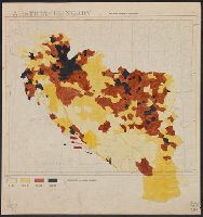
Legend indicates "Inhabitants per square kilometer."
Publisher:
s.n.,
Subject (Geographic):
Europe, Eastern--Maps
Subject (Topic):
Population density--Europe, Eastern--Maps
Found in:
Beinecke Rare Book and Manuscript Library > Austria-Hungary : Population density of Jugo-slavia.
Published / Created:
1910?]
Call Number:
41 1910A
Container / Volume:
BRBL_00241
Image Count:
1
Resource Type:
Maps, Atlases & Globes
Publisher:
s.n.,
Subject (Geographic):
Austria--Maps, Balkan Peninsula--Maps, and Hungary--Maps
Found in:
Beinecke Rare Book and Manuscript Library > Austria-Hungary.
Published / Created:
1919?].
Call Number:
11hcf 1919C-3-14
Container / Volume:
BRBL_00010U
Image Count:
1
Resource Type:
Maps, Atlases & Globes
Description:
"610" in upper right and bottom left.
Publisher:
s.n.,
Subject (Geographic):
Austria--Maps and Hungary--Maps
Found in:
Beinecke Rare Book and Manuscript Library > Austria-Hungary.
Published / Created:
1919?]
Call Number:
11hcf 1919C-3-17
Container / Volume:
BRBL_00010U
Image Count:
1
Resource Type:
Maps, Atlases & Globes
Description:
In upper right and bottom left: 610.
Publisher:
s.n.,
Subject (Geographic):
Balkan Peninsula--Maps and Europe, Eastern--Maps
Found in:
Beinecke Rare Book and Manuscript Library > Austria-Hungary.
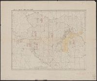
Published / Created:
1919?]
Call Number:
11hcf 1919C-3-16
Container / Volume:
BRBL_00010U
Image Count:
1
Resource Type:
Maps, Atlases & Globes
Description:
Ms. notes: Divided into land area, giving populations of various ethnic groups.
Publisher:
s.n.,
Subject (Geographic):
Balkan Peninsula--Maps and Europe, Eastern--Maps
Subject (Topic):
Ethnology--Balkan Peninsula--Maps and Ethnology--Europe, Eastern--Maps
Found in:
Beinecke Rare Book and Manuscript Library > Austria-Hungary.
Published / Created:
1919?]
Call Number:
11hcf 1919C-3-8
Container / Volume:
BRBL_00010U
Image Count:
1
Resource Type:
Maps, Atlases & Globes
Description:
Hand colored regions and borders.
Publisher:
s.n.,
Subject (Geographic):
Balkan Peninsula--Maps and Europe, Eastern--Maps
Found in:
Beinecke Rare Book and Manuscript Library > Austria-Hungary.
Creator:
Published / Created:
1864
Call Number:
801hc N17 1864
Container / Volume:
BRBL_00541
Image Count:
1
Resource Type:
Maps, Atlases & Globes
Alternative Title:
[Sherman map collection ; no. 170]
Description:
For another copy see entry no. 433., From "39th Cong., 1st Sess. [1866]-Report of the Chief Engineer, U.S.A.", and Legend in the upper left corner contains a brief resume of each day's action while the map shows troop positions, roads, railroads, hachures, drainage, vegetation, and rural houses. Streets and houses of Nashville are not indicated.
Publisher:
s.n.],
Subject (Geographic):
Nashville (Tenn.)--History--Civil War, 1861-1865--Maps
Found in:
Beinecke Rare Book and Manuscript Library > Battlefields in front of Nashville where the United States forces commanded by Major General Geo. H. Thomas defeated and routed the Rebel army under General Hood, December 15th & 16th 1864 / surveyed and drawn under the direction of Gen: Tower by M. Peseu
Creator:
Published / Created:
c1939.
Call Number:
827 B284 1939
Container / Volume:
BRBL_00577
Image Count:
1
Resource Type:
Maps, Atlases & Globes
Description:
Copyright: M.K. Jensen. and Shows "original town" and additions.
Publisher:
s.n.],
Subject (Geographic):
Bartlesville (Okla.)--Maps
Found in:
Beinecke Rare Book and Manuscript Library > City of Bartlesville, Oklahoma / compiled and drawn by M.K. Jensen.
Creator:
Published / Created:
1877]
Call Number:
844 Sa593 1877
Container / Volume:
BRBL_00610
Image Count:
1
Resource Type:
Maps, Atlases & Globes
Description:
Indexed., Library's copy annotated in ink., and Relief shown by hachures.
Publisher:
lith. Britton, Rey & Co.) and s.n.,
Subject (Geographic):
Santa Cruz (Calif.)--Maps
Found in:
Beinecke Rare Book and Manuscript Library > City of Santa Cruz, California, 1877 / compiled by Edwin Shepard.
Creator:
Published / Created:
19--?]
Call Number:
73 1814
Container / Volume:
BRBL_00374
Image Count:
1
Resource Type:
Maps, Atlases & Globes
Description:
"This map made for the North West Company in 1813 and 1814 ....", Covers British Columbia, portions of Alberta, and U.S. Pacific Northwest., Includes text., Relief shown by hachures., and Reprint of 1814[?] map.
Publisher:
s.n.,
Subject (Geographic):
Canada, Western--Maps and Northwest, Pacific--Maps
Subject (Name):
Canada. Office of the Surveyor General
Found in:
Beinecke Rare Book and Manuscript Library > Copy of a portion of map of the North-West territory of the Province of Canada : from actual survey during the years 1798 to 1812 / by David Thompson.
Branch:v1.61.6 ,Deployed:2024-06-12T09:55:37-04:00