Skip to search
Skip to main content
Skip to first result
Search
You Searched For
Genre
Maps
Language
English
Publication Place
Philadelphia :
New Search
Search Results
Creator:
Published / Created:
1865
Call Number:
816ca 1865
Container / Volume:
BRBL_00563
Image Count:
1
Resource Type:
Maps, Atlases & Globes
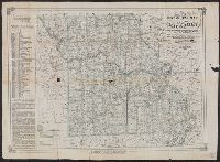
Description:
"Compiled from the U.S. Surveys, geological reports and personal reconnoisance.", Includes text., and Relief shown by hachures.
Publisher:
J.B. Lippincott & Co. ; and N.H. Parker,
Subject (Name):
J.B. Lippincott Company and Mackenzie and Gardner Lithographers
Subject (Topic):
Geology--Missouri--Maps and Mines and mineral resources--Missouri--Maps
Found in:
Beinecke Rare Book and Manuscript Library > Parker's geological map of the state of Missouri : showing the location of the principal deposits of iron, lead, zinc, tin, copper, diamonds, gold, silver, platina, nickel, manganese, alabaster, kaolin, coal, oil springs, &c. / by Nathan H. Parker ; Macke
Creator:
Published / Created:
1880
Call Number:
75gme 1880B
Container / Volume:
BRBL_00413
Image Count:
2
Resource Type:
Maps, Atlases & Globes
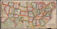
Alternative Title:
General map of the Pennsylvania Railroad and its connections.
Description:
Inset: Round the World , Across the American Continent, via the Pennsylvania Railroad. and Text and tables on verso: Pennsylvania Railroad Great Trunk Line and U.S. Mail Route, July, 1880.
Publisher:
Allen, Lane & Scott,
Subject (Geographic):
United States--Railroads
Subject (Name):
Pennsylvania Railroad--Maps
Subject (Topic):
Railroads--United States--Maps
Found in:
Beinecke Rare Book and Manuscript Library > Pennsylvania Railroad : Great Trunk Line and U.S. Mail Route.
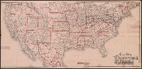
Published / Created:
1885
Call Number:
774AM P53 1886
Container / Volume:
BRBL_00500
Image Count:
6
Resource Type:
Maps, Atlases & Globes
Description:
Insets of local factories, mills. and Single map cut into 6 sheets along fold lines.
Publisher:
Burk & McFetridge ,
Subject (Geographic):
Philadelphia (Pennsylvania)--Maps
Found in:
Beinecke Rare Book and Manuscript Library > Pennsylvania in 1886.
Creator:
Published / Created:
c1876.
Call Number:
774 P53 1876A
Container / Volume:
BRBL_00500
Image Count:
1
Resource Type:
Maps, Atlases & Globes
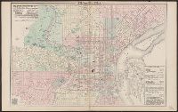
Description:
Describes location of steam railroad passenger depots., From Gray's atlas, p. 60-61., Legend in English, French and German., and Shows steam and horse railroads, wards, parks, etc.
Publisher:
O.W. Gray & Son,
Subject (Geographic):
Philadelphia (Pa.)--Maps
Found in:
Beinecke Rare Book and Manuscript Library > Philadelphia / [cartographic material] / O.W. Gray & Son.
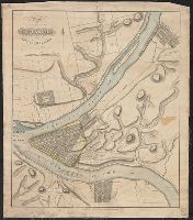
Published / Created:
[1825?]
Call Number:
774 P68 1825
Container / Volume:
BRBL_00500
Image Count:
1
Resource Type:
Maps, Atlases & Globes
Description:
Eng. by HS Tanner. and hand-colored engraving showing junction of the Allegheny & Monongahela Rivers. The plans of the developed parts of Pittsburgh, Birmingham, Allegheny, & lawrenceville are shaded. Numbered lots shown in outline. Elevations of Hills in fee
Publisher:
R. Patterson & W. Darby,
Subject (Geographic):
Pittsburgh (Pa.)--Maps
Found in:
Beinecke Rare Book and Manuscript Library > Plan of Pittsburgh and adyacent country, surveyed by Wm. Darby.
Branch:v1.61.8 ,Deployed:2024-06-20T11:14:48-04:00