Skip to search
Skip to main content
Skip to first result
Search
You Searched For
Genre
Intaglio prints
Genre
Maps
Language
English
New Search
Search Results
Creator:
Published / Created:
1614-16
Call Number:
Zd 176
Collection Title:
Path-way to experience to erect a plantation
Image Count:
1
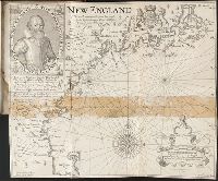
Abstract:
With engraved portrait of John Smith in upper left corner.
Description:
From an original drawn by Robert Clerke, Simon Paseus (?), lithographer, printed in London by Geor. Low., Observed and described by Captayn John Smith, 1614., Preceding table of contents., and Teaching resource: Professor John Mack Faragher, History 141: The American West.
Publisher:
Pendleton's Lithography
Subject (Geographic):
Massachusetts --History --Colonial period, ca. 1600-1775, Massachusetts --Maps --Early works to 1800, New England --Description and travel, New England --History --Colonial period, ca. 1600-1775, and New England --Maps --Early works to 1800
Subject (Name):
Clarke, Robert, fl. 1616
Collection Created:
London, Printed by I. Haviland, and are to be sold by R. Milbovrne, 1631
Found in:
Beinecke Rare Book and Manuscript Library > New England: the most remarqueable parts thus named by the high and mighty Prince Charles, Prince of Great Britaine
Creator:
Call Number:
Taylor 388
Collection Title:
The English empire in America: or A prospect of His Majesties dominions in the West-Indies ... By R
Image Count:
1
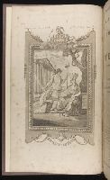
Description:
Facing title page.
Subject (Geographic):
America --Discovery and exploration, Great Britain --Colonies --America, and North America --Description and travel
Subject (Topic):
Indians of North America
Collection Created:
Printed for Nath. Crouch at the Bell in the Poultrey near Cheapside. 1685
Found in:
Beinecke Rare Book and Manuscript Library > The English empire in America
Creator:
Call Number:
1976 Folio 110
Collection Title:
The mariners mirrovr wherin may playnly be seen the courses, heights, distances, depths, sounding
Image Count:
1
Resource Type:
Maps, Atlases & Globes
Subject (Geographic):
Dover (England), England, English Channel, and Isle of Wight (England)
Collection Created:
[London, J. Charlewood? 1588]
Found in:
Beinecke Rare Book and Manuscript Library > The sea coastes of England betweene the Ile of Wight & Douer, with the principal hauens thereof according to their situation and appearing
Creator:
Call Number:
1976 Folio 110
Collection Title:
The mariners mirrovr wherin may playnly be seen the courses, heights, distances, depths, sounding
Image Count:
1
Resource Type:
Maps, Atlases & Globes
Subject (Geographic):
Bristol Channel, England, and English Channel
Collection Created:
[London, J. Charlewood? 1588]
Found in:
Beinecke Rare Book and Manuscript Library > The sea coastes of England, from the Sorlinges by the landes end to Plymouth with the hauens and harbrowghes
Creator:
Call Number:
1976 Folio 110
Collection Title:
The mariners mirrovr wherin may playnly be seen the courses, heights, distances, depths, sounding
Image Count:
1
Resource Type:
Maps, Atlases & Globes
Subject (Geographic):
Portugal
Collection Created:
[London, J. Charlewood? 1588]
Found in:
Beinecke Rare Book and Manuscript Library > The sea coastes of Portugal betwene Camino & Montego eue as the countrie there aboutes is lying and situated with all the havens thereof exactly done, and corected with great dilligence
Call Number:
MMLm143 778bc
Collection Title:
The self-interpreting Bible: containing the sacred text of the Old and New Testaments. Translated
Image Count:
5
Description:
Binder’s title: Brown’s Bible. and Includes bound in map of the Holy Land (folded) 42 x 24 cm.
Subject (Topic):
Bible. O.T. and Palestine--Maps--Early works to 1800
Collection Created:
New-York : Printed by Hodge and Campbell, and sold at their respective book stores, M.DCC.XCII
Found in:
Beinecke Rare Book and Manuscript Library > [Selected pages]
Branch:v1.61.6 ,Deployed:2024-06-12T09:55:33-04:00