Includes text in German and English protesting the proposed boundaries of Czechoslovakia as infringing upon ethnically German, Slovakian and Polish territories.
Publisher:
L.V. Enders'schen K.-A.,
Subject (Geographic):
Czech Republic--Boundaries--Germany--Maps and Germany--Boundaries--Czech Republic--Maps
Subject (Topic):
Germans--Czech Republic--Bohemia--Maps, Germans--Czech Republic--Sudetenland--Maps, and World War, 1914-1918--Territorial questions--Maps
"Zu Ebelings Erdbeschr, Also shows county boundaries., In upper right margin: No. XVI., Place names in German and English., Prime meridians: Greenwich and Washington., Relief shown by hachures., and Sheet measures 72.4 x 50.5 cm. Franklin Collection no. 131 1796 1.
Publisher:
Bey Carl Ernst Bohn,
Subject (Geographic):
Vermont--Administrative and political divisions--Maps--Early works to 1800 and Vermont--Maps--Early works to 1800
Subject (Name):
Bohn, Carl Ernst, publisher, Ebeling, Christophe Daniel, 1741-1817. Erdbeschreibung und Geschichte von Amerika, and Schmidt, Paulus, engraver
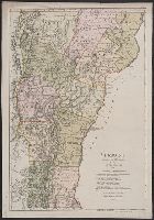
"Zu Ebelings Erdbeschreibung von Amerika.", Also shows county boundaries., In upper right margin: No. XVI., Place names in German and English., Prime meridians: Greenwich and Washington., Relief shown by hachures., and Sheet measures 74.9 x 54.1 cm. Ms. no.: L.C. 9
Bohn, Carl Ernst, publisher Ebeling, Christophe Daniel, 1741-1817. Erdbeschreibung und Geschichte von Amerika Schmidt, Paulus, engraver Sotzmann, D. F
Published / Created:
1796
Call Number:
1977 Folio 177
Image Count:
2
Resource Type:
Maps, Atlases & Globes
Description:
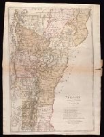
"Zu Ebelings Erdbeschreibung von Amerika.", Also shows county boundaries., Bar scales given in "Geographische Meilen 15 auf einen Grad" and "Englische meilen 69 4/25 auf einen Grad.", In upper right margin: No. XVI., Place names in German and English., Prime meridians: Greenwich and Washington., Relief shown by hachures., Sheet measures 72.8 x 54.3 cm. No. 10 of 34 maps bound together., and Watermark.
Publisher:
Bey Carl Ernst Bohn,
Subject (Geographic):
Vermont--Administrative and political divisions--Maps--Early works to 1800 and Vermont--Maps--Early works to 1800