Skip to search
Skip to main content
Skip to first result
Search
You Searched For
Genre
Maps.
Resource Type
Maps, Atlases & Globes
Publication Place
Paris :
New Search
Search Results
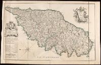
Creator:
Published / Created:
1738
Call Number:
3897 1738
Container / Volume:
BRBL_00183
Image Count:
1
Resource Type:
Maps, Atlases & Globes
Description:
Coordinates not present on map and are approximated., Includes dedication to "Monsieur le Marquis Brignole Sale"., North oriented towards the left., Relief shown by hachures and pictorially., and Watermark.
Publisher:
chez le Sr. Jaillot Geographe Ordinaire du Roy, Quay et attenant les Grands Augustins, aux Deux Globes,
Subject (Geographic):
Corsica (France)--Maps--Early works to 1800.
Subject (Name):
Delahaye, Jean Baptiste Henri, engraver.
Found in:
Beinecke Rare Book and Manuscript Library > Carte particuliere de l'Isle de Corse : divisée par ses dix provinces ou juridictions et ses quatre fiefs / levée ... par le Sr. Bernard Antoine Jaillot Geographe Ordre. du Roy ; Delahaye sculpsit.
Creator:
Published / Created:
1814
Call Number:
49cea 1814
Image Count:
2
Resource Type:
Maps, Atlases & Globes
Description:
Imperfect: Sheets 1-2 only; mutilated with loss of information., Includes Adriatic and Azof Seas., and Relief shown by hachures. Depths shown in soundings.
Publisher:
Chez Rey et Gravier,
Subject (Geographic):
Black Sea--Maps. and Mediterranean Sea--Maps.
Found in:
Beinecke Rare Book and Manuscript Library > Carte réduite de la Mer Méditerranée et de la Mer Noire / par P. Lapie ; gravée par P.A.F Tardieu ; écrit par J.J. Pachouse.
Creator:
Published / Created:
[1846]
Call Number:
BrSides Folio 2017 14
Image Count:
1
Resource Type:
Maps, Atlases & Globes
Description:
"Atlas National Illustré.", "Hémisphére Boréal & Austral no. 91.", and Extensive illustrations of animals, landscape, people, surround the maps.
Publisher:
L'Editeur, Rue de la Parcheminerie, 15,
Subject (Geographic):
Madagascar--Maps. and Senegal--Maps.
Subject (Name):
Bonheur, Raimond. and Laguillermie, active 1830-1854, engraver.
Found in:
Beinecke Rare Book and Manuscript Library > Colonies françaises (en Afrique) [cartographic material] / géographie et statistique par V. Levasseur ; illustré par Raimond Bonheur ; grave par Laguillermie.
Branch:v1.61.6 ,Deployed:2024-06-12T09:55:31-04:00