Skip to search
Skip to main content
Skip to first result
Search
You Searched For
Resource Type
Maps, Atlases & Globes
Creator
United States. General Land Office
Subject (Name)
Bond, Frank, 1856-1940
New Search
Search Results
Creator:
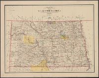
Published / Created:
1903
Call Number:
822 1903
Container / Volume:
BRBL_00567
Image Count:
1
Resource Type:
Maps, Atlases & Globes
Description:
Relief shown by shading.
Publisher:
Dept. of the Interior, General Land Office,
Subject (Geographic):
North Dakota--Maps
Subject (Name):
Bauman, Wm. (William), Bond, Frank, 1856-1940, and Hendges, M
Found in:
Beinecke Rare Book and Manuscript Library > Map of the state of North Dakota / compiled from the official records of the General Land Office and other sources under the direction of Frank Bond ; compiled and drawn by M. Hendges ; lettered by Wm. Bauman, Jr.
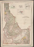
Creator:
Published / Created:
1907
Call Number:
832 1907
Container / Volume:
BRBL_00582
Image Count:
1
Resource Type:
Maps, Atlases & Globes
Abstract:
Shows township, railroad & county lines, forest, military & Indian reservations, etc.
Description:
Insets: Boise and vicinity -- Pocatello and vicinity -- Wallace and vicinity -- Lewiston and vicinity., Prime meridians: Greenwich and Washington., and Relief shown by shading.
Publisher:
General Land Office,
Subject (Geographic):
Idaho--Maps
Subject (Name):
Andrew B. Graham Co, Bond, Frank, 1856-1940, and Helm, Charles J
Found in:
Beinecke Rare Book and Manuscript Library > State of Idaho : 1907 / compiled from the official records of the General Land Office and other sources under the direction of Frank Bond ; rev. & drawn by Charles J. Helm.
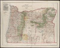
Creator:
Published / Created:
1906
Call Number:
846 1906
Container / Volume:
BRBL_00621
Image Count:
1
Resource Type:
Maps, Atlases & Globes
Abstract:
Shows county boundaries, military and Indian reservations, forest reserves, national parks, military roads, and lighthouses.
Description:
Gives longitude west from Greenwich and Washington, D.C., Inset: City of Portland., and Relief shown by shading.
Publisher:
The Office,
Subject (Geographic):
Oregon--Maps
Subject (Name):
Andrew B. Graham Co, Bauman, Wm. (William), Bond, Frank, 1856-1940, Dinsmore, A. F, and Hendges, M
Found in:
Beinecke Rare Book and Manuscript Library > State of Oregon / compiled from the official records of the General Land Office and other sources under the direction of Frank Bond ; compiled by M. Hendges ; revised by A.F. Dinsmore ; traced and lettered by Wm. Bauman Jr.
Branch:v1.61.6 ,Deployed:2024-06-12T09:55:19-04:00