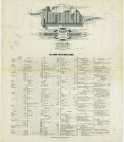
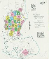
Sanborn fire insurance maps are a rich source of historic data on the urban built environment of North America during the 19th and early 20th centuries. The atlases were created for the purpose of underwriting fire insurance policies, which depended upon accurate and frequently-updated information about construction materials, municipal and transportation infrastructure, industrial and commercial landuse and more. The Yale University Library Map Department scanned its holdings of Sanborn fire insurance maps (consisting primarily of Connecticut towns) in order to make the maps more accessible.
Alternative Title:
Norwich, New London Co., Connecticut and Nov. 1914, Norwich, Conn.
Description:
"32 sheets. (122).", Contains information on population, water facilities, and fire department., Includes index of streets and specials., Partial cadastral map., Sheets 1-14, 17-19, 21-29 and 31-32 at scale 1:600 ; sheets 15-16, 20, and 30 at scale 1:1,200., SMLMAPL 766 N835 1914: Sheets disbound. Library of Congress copyright stamp on title sheet., and The unnumbered leaf is the title and index sheet.
Subject (Geographic):
Norwich (Conn.)--Maps
Subject (Name):
Library of Congress Stamp
Subject (Topic):
Fire risk assessment--Connecticut--Norwich--Maps and Real property--Connecticut--Norwich--Maps
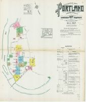
Sanborn fire insurance maps are a rich source of historic data on the urban built environment of North America during the 19th and early 20th centuries. The atlases were created for the purpose of underwriting fire insurance policies, which depended upon accurate and frequently-updated information about construction materials, municipal and transportation infrastructure, industrial and commercial landuse and more. The Yale University Library Map Department scanned its holdings of Sanborn fire insurance maps (consisting primarily of Connecticut towns) in order to make the maps more accessible.
Alternative Title:
Oct. 1912, Portland, Conn. and Portland, Middlesex County, Connecticut
Description:
"13 sheets. (5539).", Contains information on population, prevailing winds, water facilities and fire department., Includes index of streets and specials., Partial cadastral map., SMLMAPL 766 P83 1912: Sheets disbound. "Triplicate" stamp on all sheets. Library of Congress copyright stamp on title sheet., and Some sheets: "Gildersleeve."
Subject (Geographic):
Portland (Conn.)--Maps
Subject (Name):
Library of Congress Stamp
Subject (Topic):
Fire risk assessment--Connecticut--Portland--Maps and Real property--Connecticut--Portland--Maps
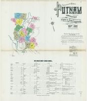
Sanborn fire insurance maps are a rich source of historic data on the urban built environment of North America during the 19th and early 20th centuries. The atlases were created for the purpose of underwriting fire insurance policies, which depended upon accurate and frequently-updated information about construction materials, municipal and transportation infrastructure, industrial and commercial landuse and more. The Yale University Library Map Department scanned its holdings of Sanborn fire insurance maps (consisting primarily of Connecticut towns) in order to make the maps more accessible.
Alternative Title:
Putnam, Windham County, Connecticut and Sept. 1910, Putnam, Conn.
Description:
"16 sheets. (2916).", Contains information on population, water facilities, and fire department., Includes index of streets and specials., Partial cadastral map., and SMLMAPL 766 P98 1910: Sheets disbound. "Triplicate" stamp on all sheets. Library of Congress copyright stamp on title sheet.
Subject (Geographic):
Putnam (Conn.)--Maps
Subject (Name):
Library of Congress Stamp
Subject (Topic):
Fire risk assessment--Connecticut--Putnam--Maps and Real property--Connecticut--Putnam--Maps
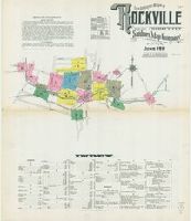
Sanborn fire insurance maps are a rich source of historic data on the urban built environment of North America during the 19th and early 20th centuries. The atlases were created for the purpose of underwriting fire insurance policies, which depended upon accurate and frequently-updated information about construction materials, municipal and transportation infrastructure, industrial and commercial landuse and more. The Yale University Library Map Department scanned its holdings of Sanborn fire insurance maps (consisting primarily of Connecticut towns) in order to make the maps more accessible.
Alternative Title:
June 1911, Rockville, Conn. and Rockville, Tolland County, Connecticut
Description:
"14 sheets. 3817.", Contains information on population, prevailing winds, water facilities and fire department., Includes index of streets and specials., Partial cadastral map., and SMLMAPL 766 R593 1911: Sheets disbound. "Triplicate" stamp on all sheets. Library of Congress copyright stamp on title sheet.
Subject (Geographic):
Rockville (Conn.)--Maps
Subject (Name):
Library of Congress Stamp
Subject (Topic):
Fire risk assessment--Connecticut--Rockville--Maps and Real property--Connecticut--Rockville--Maps
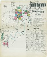
Sanborn fire insurance maps are a rich source of historic data on the urban built environment of North America during the 19th and early 20th centuries. The atlases were created for the purpose of underwriting fire insurance policies, which depended upon accurate and frequently-updated information about construction materials, municipal and transportation infrastructure, industrial and commercial landuse and more. The Yale University Library Map Department scanned its holdings of Sanborn fire insurance maps (consisting primarily of Connecticut towns) in order to make the maps more accessible.
Alternative Title:
Feb. 1906, South Norwalk, Conn. and South Norwalk, East Rowayton and Bell Island, Norwalk, Fairfield County, Connecticut
Description:
"21 sheets (8616).", Contains information on population, prevailing winds, water facilities and fire department., Includes index of streets and specials., Partial cadastral map., SMLMAPL 766 So885 1906: Sheets disbound. "Triplicate" stamp on all sheets. Library of Congress copyright stamp on title sheet., and Some sheets have subtitles: East Norwalk, Rowayton, or Roton Point.
Subject (Geographic):
Norwalk (Conn.)--Maps and South Norwalk (Norwalk, Conn.)--Maps
Subject (Name):
Library of Congress Stamp
Subject (Topic):
Fire risk assessment--Connecticut--Norwalk--Maps, Fire risk assessment--Connecticut--Norwalk--South Norwalk--Maps, Real property--Connecticut--Norwalk--Maps, and Real property--Connecticut--Norwalk--South Norwalk--Maps
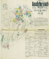
Sanborn fire insurance maps are a rich source of historic data on the urban built environment of North America during the 19th and early 20th centuries. The atlases were created for the purpose of underwriting fire insurance policies, which depended upon accurate and frequently-updated information about construction materials, municipal and transportation infrastructure, industrial and commercial landuse and more. The Yale University Library Map Department scanned its holdings of Sanborn fire insurance maps (consisting primarily of Connecticut towns) in order to make the maps more accessible.
Alternative Title:
Jan. 1912, South Norwalk, Conn. and South Norwalk, including East Norwalk, Rowayton, Bell Island, and Roton Point, Fairfield Co., Connecticut
Description:
"28 sheets (4556).", Contains information on population, prevailing winds, water facilities and fire department., Includes index of streets and specials., Partial cadastral map., SMLMAPL 766 So885 1912: Sheets disbound. "Triplicate" stamp on all sheets. Library of Congress copyright stamp on title sheet., and Some sheets have subtitles: East Norwalk or Rowayton.
Subject (Geographic):
Norwalk (Conn.)--Maps and South Norwalk (Norwalk, Conn.)--Maps
Subject (Name):
Library of Congress Stamp
Subject (Topic):
Fire risk assessment--Connecticut--Norwalk--Maps, Fire risk assessment--Connecticut--Norwalk--South Norwalk--Maps, Real property--Connecticut--Norwalk--Maps, and Real property--Connecticut--Norwalk--South Norwalk--Maps
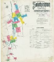
Sanborn fire insurance maps are a rich source of historic data on the urban built environment of North America during the 19th and early 20th centuries. The atlases were created for the purpose of underwriting fire insurance policies, which depended upon accurate and frequently-updated information about construction materials, municipal and transportation infrastructure, industrial and commercial landuse and more. The Yale University Library Map Department scanned its holdings of Sanborn fire insurance maps (consisting primarily of Connecticut towns) in order to make the maps more accessible.
Alternative Title:
Oct. 1906, Southington, Conn. and Southington, Hartford County, Connecticut
Description:
"14 sheets. (9027).", Contains information on population, prevailing winds, water facilities and fire department., Includes index of streets and specials., Partial cadastral map., and SMLMAPL 766 So87 1906: Sheets disbound. "Triplicate" stamp on all sheets. Library of Congress copyright stamp on title sheet.
Subject (Geographic):
Southington (Conn.)--Maps
Subject (Name):
Library of Congress Stamp
Subject (Topic):
Fire risk assessment--Connecticut--Southington--Maps and Real property--Connecticut--Southington--Maps
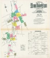
Sanborn fire insurance maps are a rich source of historic data on the urban built environment of North America during the 19th and early 20th centuries. The atlases were created for the purpose of underwriting fire insurance policies, which depended upon accurate and frequently-updated information about construction materials, municipal and transportation infrastructure, industrial and commercial landuse and more. The Yale University Library Map Department scanned its holdings of Sanborn fire insurance maps (consisting primarily of Connecticut towns) in order to make the maps more accessible.
Alternative Title:
July 1911, Southington, Conn. and Southington, Hartford County, Connecticut
Description:
"15 sheets. 3840.", Contains information on population, prevailing winds, water facilities and fire department., Includes index of streets and specials., Partial cadastral map., and SMLMAPL 766 So87 1911: Sheets disbound. Library of Congress copyright stamp on title sheet.
Subject (Geographic):
Southington (Conn.)--Maps
Subject (Name):
Library of Congress Stamp
Subject (Topic):
Fire risk assessment--Connecticut--Southington--Maps and Real property--Connecticut--Southington--Maps
Sanborn fire insurance maps are a rich source of historic data on the urban built environment of North America during the 19th and early 20th centuries. The atlases were created for the purpose of underwriting fire insurance policies, which depended upon accurate and frequently-updated information about construction materials, municipal and transportation infrastructure, industrial and commercial landuse and more. The Yale University Library Map Department scanned its holdings of Sanborn fire insurance maps (consisting primarily of Connecticut towns) in order to make the maps more accessible.
Alternative Title:
Jan. 1924, Stratford, Conn. and Stratford, including Lordship Manor, Fairfield County, Connecticut
Description:
"41 sheets. (1402).", Contains information on population, prevailing winds, water facilities and fire department., Includes index of streets and specials., Partial cadastral map., Sheets 1-7, 23-24, 27-34 and 41 at scale 1:600 ; sheets 8-22, 25-26, and 35-40 at scale 1:1,200., and SMLMAPL 766 St82 1924: Sheets disbound. Library of Congress copyright stamp on title sheet.
Subject (Geographic):
Stratford (Conn.)--Maps
Subject (Name):
Library of Congress Stamp
Subject (Topic):
Fire risk assessment--Connecticut--Stratford--Maps and Real property--Connecticut--Stratford--Maps
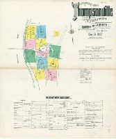
Sanborn fire insurance maps are a rich source of historic data on the urban built environment of North America during the 19th and early 20th centuries. The atlases were created for the purpose of underwriting fire insurance policies, which depended upon accurate and frequently-updated information about construction materials, municipal and transportation infrastructure, industrial and commercial landuse and more. The Yale University Library Map Department scanned its holdings of Sanborn fire insurance maps (consisting primarily of Connecticut towns) in order to make the maps more accessible.
Alternative Title:
Mar. 1912 Thompsonville, Conn. and Thompsonville, Hartford County, Connecticut.
Description:
"12 sheets (4715).", Contains information on population, prevailing winds, water facilities and fire department., Includes index of streets and specials., Partial cadastral map., and SMLMAPL 766 T372 1912: Sheets disbound. "Triplicate" stamp on sheet. Library of Congress copyright stamp on title sheet.
Subject (Geographic):
Thompsonville (Conn.)--Maps
Subject (Name):
Library of Congress Stamp
Subject (Topic):
Fire risk assessment--Connecticut--Thompsonville--Maps and Real property--Connecticut--Thompsonville--Maps