Search
You Searched For
Search Results
- Published / Created:
- 1854
- Call Number:
- 1976 Folio 96
- Collection Title:
- A new universal atlas containing maps of the various empires, kingdoms, states and republics of the
- Image Count:
- 1
- Resource Type:
- Maps, Atlases & Globes
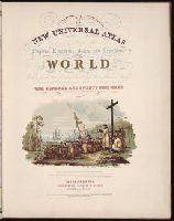
- Description:
- Chromolith of P.S. Duval & Co. Phila. and Illustrated vignette depicting the first landing of Columbus in the new world.
- Collection Created:
- Philadelphia, Cowperthwait, DeSilver & Butler, 1854, c1850
- Found in:
- Beinecke Rare Book and Manuscript Library > A new universal atlas containing maps of the various empires, kingdoms, states and republics of the world ...
- Creator:
- P.S. Duval & Son
Wissler, J.
- Published / Created:
- 1850
- Call Number:
- 1975 Folio 26
- Collection Title:
- A new universal atlas containing maps of the various empires, kingdoms, states and republics of the
- Image Count:
- 1
- Resource Type:
- Maps, Atlases & Globes
- Collection Created:
- Philadelphia, Thomas, Cowperthwait & Co., No. 253 Market street, 1852
- Found in:
- Beinecke Rare Book and Manuscript Library > A new universal atlas containing maps of the various empires, kingdoms, states and republics of the world ...
- Creator:
- Barralet, John James, 1747-1815
Humphrys, William, 1794-1865
- Published / Created:
- 1836
- Call Number:
- 1976 Folio 98
- Collection Title:
- A new universal atlas, containing maps of the various empires, kingdoms, states and republics of
- Image Count:
- 1
- Resource Type:
- Maps, Atlases & Globes
- Description:
- Illustrated vignette depicting the first landing of Columbus in the new world.
- Collection Created:
- Philadelphia, Published by the author, 1836
- Found in:
- Beinecke Rare Book and Manuscript Library > A new universal atlas, containing maps of the various empires, kingdoms, states and republics of the world ...
- Call Number:
- 1983 Folio 50
- Collection Title:
- Atlas novus sive Tabulae geographicae totius orbis faciem : partes, imperia, regna et provincias
- Image Count:
- 2
- Resource Type:
- Maps, Atlases & Globes
- Alternative Title:
- Erklaerung deren figuren, so sich auf der historischen land-charten von teutschland, und deren angraenzenden laendern befinden
- Description:
- Both versos blank.
- Subject (Topic):
- Atlases --Early works to 1800 and Atlases, German
- Collection Created:
- Augustae Vindelicorum : [M. Seutter, 1757?]
- Found in:
- Beinecke Rare Book and Manuscript Library > Historia Imperii Romano-Germanici, nec non finitimarum Regionum In Mappa exhibita, ac aeri incisa a Mattheo Seutter ...