
You Searched For
1 - 6 of 6
Search Results


- Creator:
- Visscher, Nicolaes, 1618-1679
- Published / Created:
- anno 1653
- Call Number:
- 1983 Folio 19
- Collection Title:
- [Atlas factice of 96 maps by Blaeu, Visscher, Jansson, Hondius and others]
- Image Count:
- 2
- Resource Type:
- Maps, Atlases & Globes
- Description:
- All four sides of map decorated with city views and costumed figures of different social classes. Includes coats of arms., Imperfect: torn along fold, with some loss of text; portions of decorative border cut or torn and repaired, with missing sections replicated in ms.; tears repaired., and No. 5 of 92 maps bound together.
- Publisher:
- Excusum in aedibus auctoris
- Subject (Geographic):
- Asia --Maps --Early works to 1800
- Subject (Topic):
- Atlases --Early works to 1800
- Collection Created:
- [1556-1680]
- Found in:
- Beinecke Rare Book and Manuscript Library > Asiae nova descriptio / auctore Nicola. Io. Visscher
3.

- Creator:
- Cornell, D. E.
Kansas Pacific Railway Company - Published / Created:
- 1878
- Call Number:
- Zc49 +878co
- Image Count:
- 36
- Resource Type:
- Books, Journals & Pamphlets
- Description:
- On cover: Compliments of Kansas Pacific Railway Company. and Original wrappers.
- Publisher:
- Ramsey, Millet & Hudson
- Subject (Topic):
- Colorado--Description and travel, Colorado--Guidebooks, Kansas--Description and travel, and Kansas--Guidebooks
- Found in:
- Beinecke Rare Book and Manuscript Library > Colorado tourist and illustrated guide via the "Golden Belt Route," to the Rocky Mountain resorts

- Creator:
- Astrophilus, fl. 1742
Seutter, Matthaeus, 1678-1756 - Published / Created:
- [1742?]
- Call Number:
- BrSides Folio 2009 4
- Image Count:
- 1
- Resource Type:
- Maps, Atlases & Globes
- Abstract:
- Includes text and celestial sphere (25.2 cm in diam.) centered on the Earth.
- Publisher:
- [Matthaeus Seutter]
- Subject (Topic):
- Comets --1742 --Charts, diagrams, etc., Comets --Early works to 1800, and Stars --Charts, diagrams, etc. --Early works to 1800
- Found in:
- Beinecke Rare Book and Manuscript Library > Cometa, qui anno Christi 1742 apparuit, ex observationibus, a die 13 Marty usque ad 15 Aprilis : plusquam vigesies quinquies institutis, qua potuit fieri, diligentia notatus, et secundum suas proprietates plerasq[ue], ab astronomia considerari solitas, utpote formam, viam, progressum, plagam coeli, motus velocitatem, descensum ad perigaeum, seu approximationem ad terram, et elongationem ab ea : item distantiam infra, vel supra` horizontem rectum, et etiam obliquum, quoties, saltem intra polum mundi, meridianum constantiensem, et locorum sub elevatione poli 47. grad. 24. min. jacentium, attigit : praecipue vero secundum ascensionem rectam, et declinationem, longitudinem, et latitudinem : et tandem secundum dies, et tempora, lineae trajectoriae inserta, cum in plano tum in figura armillari exhibitus : ubi tum nudo intuitu, tum ope regulae, et circini omnia facile investigantur / observante, et delineante Astrophilo quodam, ex Ord. S. Bened. nomina qui Christo gaudet inesse sua ; a Matth. Seuttero S.C.M.G. Aug. V
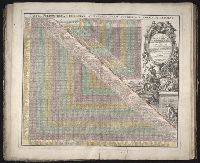
- Creator:
- Homann Erben (Firm)
- Published / Created:
- 1731
- Call Number:
- 1973 Folio 30
- Collection Title:
- [Atlas factice of 32 maps and 1 distance table, produced by the Homann Erben firm]
- Image Count:
- 2
- Alternative Title:
- Tabula poliometrica Germaniae ac praecipuorum quorundam locorum Europae
- Publisher:
- In der Homannische Ufficin
- Subject (Geographic):
- Europe --Distances, etc --Early works to 1800
- Subject (Topic):
- Atlases, German --Early works to 1800
- Collection Created:
- [Nuremberg : s.n., 1701-1760]
- Found in:
- Beinecke Rare Book and Manuscript Library > Neu vermehrter curioser Meilen-Zeiger der vornehmsten Staedte in Europa, besonders in Teutschland ...

- Creator:
- Wadsworth, James, 1730-1817
- Published / Created:
- 1748
- Call Number:
- ZZ35 5 1
- Image Count:
- 1
- Resource Type:
- Maps, Atlases & Globes
- Abstract:
- Manuscript map in blue and red ink depicting the original nine squares. This map is possibly the original drawing by James Wadsworth, drawn from actual surveys.
- Description:
- Pen-and-ink and watercolor with linen backing.
- Subject (Geographic):
- New Haven (Conn.) --Maps --Early works to 1800
- Found in:
- Beinecke Rare Book and Manuscript Library > Plan of the city of New Haven taken in 1748