Skip to search
Skip to main content
Skip to first result
Search
You Searched For
Format
cartographic
Publication Place
[S.l. :
New Search
Search Results
Published / Created:
ca. 1790?]
Call Number:
71 1790C
Container / Volume:
BRBL_00367
Image Count:
1
Resource Type:
Maps, Atlases & Globes
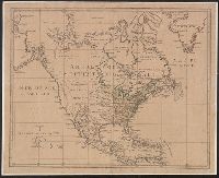
Description:
Differs in coloring from Yale's other copy, with Latin America and land west of the Mississippi uncolored; and height approx. 3 mm. more than other copy., Relief shown pictorially., and Shows "Republique des XIII provinces"; "Nouveau Mexique" extending to appro
Publisher:
s.n.,
Subject (Geographic):
North America--Maps--Early works to 1800
Found in:
Beinecke Rare Book and Manuscript Library > [Amérique Septentrionale].
Published / Created:
ca. 1790?]
Call Number:
71 1790
Container / Volume:
BRBL_00367
Image Count:
1
Resource Type:
Maps, Atlases & Globes
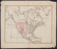
Description:
Differs in coloring from Yale's other copy, with Latin America and land west of the Mississippi washed in pink; and height approx. 3 mm. less than other copy., Relief shown pictorially., and Shows "Republique des XIII provinces"; "Nouveau Mexique" extending to
Publisher:
s.n.,
Subject (Geographic):
North America--Maps--Early works to 1800
Found in:
Beinecke Rare Book and Manuscript Library > [Amérique Septentrionale].
Published / Created:
18--]
Call Number:
40 V55 1830
Container / Volume:
BRBL_00705
Image Count:
1
Resource Type:
Maps, Atlases & Globes
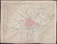
Description:
A strip of paper has been overlaid within the lower left neat line., Central Venice and some outlying areas appear finished, but there are extensive unfinished areas with notations in pencil., dgvmp2008., and Map extends beyond neat lines.
Publisher:
s.n. ,
Subject (Geographic):
Venice Region (Italy)--Maps
Found in:
Beinecke Rare Book and Manuscript Library > [An unfinished manuscript map of the area around Venice, including Fusina, Marghera, Murano, S. Erasmo, Le Vignole, Lazzaretto and S. Spirito.]
Published / Created:
1910?]
Call Number:
41 1910
Container / Volume:
BRBL_00241
Image Count:
1
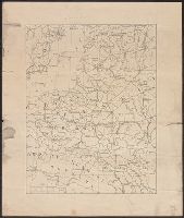
Resource Type:
Maps, Atlases & Globes
Publisher:
s.n.,
Subject (Geographic):
Austria--Maps, Balkan Peninsula--Maps, and Hungary--Maps
Found in:
Beinecke Rare Book and Manuscript Library > [Austrian Empire].
Published / Created:
1919?]
Call Number:
11hcf 1919B-32
Container / Volume:
BRBL_00010Q
Image Count:
1
Resource Type:
Maps, Atlases & Globes
Description:
BEIN 11hcf 1919B-32: Devised title in manuscript in upper margin. and Title devised by cataloger.
Publisher:
s.n.,
Subject (Geographic):
Baltic States--Maps. and Europe, Central--Maps.--http://id.loc.gov/authorities/subjects/sh2008114963
Found in:
Beinecke Rare Book and Manuscript Library > [Baltic states].
Published / Created:
1633?]
Call Number:
322 1633
Container / Volume:
BRBL_00059
Image Count:
2
Resource Type:
Maps, Atlases & Globes
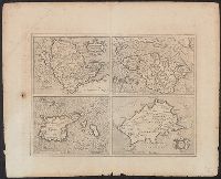
Description:
Anglesey, Wight vectis olim, Garnesay, Iarsay. and Preliminary record.
Publisher:
S.n. ,
Subject (Geographic):
Channel Islands--Maps--Early works to 1800
Found in:
Beinecke Rare Book and Manuscript Library > [Channel Islands]
Published / Created:
1919?]
Call Number:
11hcf 1919B-30
Container / Volume:
BRBL_00010Q
Image Count:
1
Resource Type:
Maps, Atlases & Globes
Description:
Title supplied by cataloger.
Publisher:
s.n.,
Subject (Geographic):
Adriatic Sea--Maps, Balkan Peninsula--Maps, and Italy--Maps
Found in:
Beinecke Rare Book and Manuscript Library > [Coast of the Adriatic Sea].
Published / Created:
1860
Call Number:
464 1860
Container / Volume:
BRBL_00261
Image Count:
1
Resource Type:
Maps, Atlases & Globes
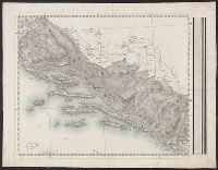
Description:
In upper right: No. 12., Possibly part of larger map including Istria., and Title supplied by cataloger.
Publisher:
s.n.,
Subject (Geographic):
Dalmatia (Croatia)--Maps
Found in:
Beinecke Rare Book and Manuscript Library > [Dalmatia].
Published / Created:
1919?]
Call Number:
11hcf 1919B-34
Container / Volume:
BRBL_00010Q
Image Count:
1
Resource Type:
Maps, Atlases & Globes
Description:
Title supplied by cataloger.
Publisher:
s.n.,
Subject (Geographic):
Europe--Maps
Found in:
Beinecke Rare Book and Manuscript Library > [Europe].
Creator:
Published / Created:
ca. 1942]
Call Number:
36 L65 1942
Container / Volume:
BRBL_00125
Image Count:
2
Resource Type:
Maps, Atlases & Globes
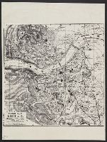
Description:
[Western sheet] -- [Eastern sheet]., Facsimile., and Stamp on verso: Office of Strategic Services, Map Division, Map Information Section.
Publisher:
OSS,
Subject (Geographic):
Linz (Austria)--Maps
Subject (Name):
United States. Office of Strategic Services Stamp
Found in:
Beinecke Rare Book and Manuscript Library > [Facsimile map of Linz, Austria].
Branch:v1.61.8 ,Deployed:2024-06-20T11:14:48-04:00