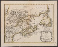
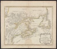
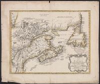
Has watermarks., Relief shown pictorially; depths shown by soundings., and Sheet measures 53 x 62 cm. Stamp of William Inglis Morse. "145" in ink ms.
Subject (Geographic):
Maritime Provinces--Maps--Early works to 1800 and New France--Maps--Early works to 1800
Subject (Name):
Bellin, Jacques Nicolas, 1703-1772. Partie occidentale de la Nouvelle France ou du Canada, Homann Erben (Firm), and Morse, William Inglis,--b. 1874--Stamp
Mappe-monde qui représente les deux hemisphères savoir celui de l'orient et celui de l'occident, tirée des quatre cartes générales de feu M. le profess. Hasius, Planiglobii terrestris mappa vniversalis, and Schul-Atlas von zwantzig General- und Special-Lan
Description:
Appears in Homann heirs' Schul-atlas von zwantzig general-und special-land karten ... Cf. Phillips, no. 293., Imperfect: torn along fold, with no loss of text. Shee, Map colored to show distribution of religions., and Title in Latin and French; legend in German.
Publisher:
Homann Erben],
Subject (Name):
Hase, Johann Matthias, 1684-1742 and Homann Erben (Firm)
Subject (Topic):
Religion--Maps--Early works to 1800 and World maps--Early works to 1800