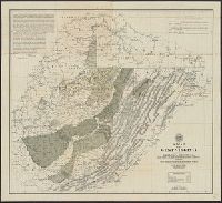
Also covers part of Pennsylvania, Maryland, Kentucky, and Ohio., Below lower margin at left: A. Hoen & Co. Lith., Include text at upper left & right corners within map border., Includes chart of explanations., Relief shown by hachures., and Shows state and county
Publisher:
West Virginia Geological and Economic Survey?],
Subject (Geographic):
West Virginia--Maps
Subject (Name):
A. Hoen & Co, West Virginia Geological and Economic Survey, and White, I. C. (Israel Charles), 1848-1927
Subject (Topic):
Geology--West Virginia--Maps and Mines and mineral resources--West Virginia
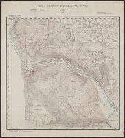
"Contour interval 5 ft. Datum, mean low water at Baltimore."., "Drawn by Thos. M. Ward, Jan'y. 1895"., and Relief shown by contours, isolines, and pictorially.
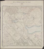
"Contour interval 5 ft. Datum, mean low water at Baltimore."., "Drawn by M.A. Cudlipp, Oct.1894"., and Relief shown by contours, isolines, and pictorially.
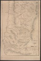
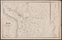
"Third annual report Reclamation Service, Pl. XXXI.", Relief shown by hachures and spot heights., and Shows irrigable lands, surveyed canal lines, and irrigation canals under construction.
Publisher:
U.S. G.P.O,
Subject (Name):
A. Hoen & Co and Geological Survey (U.S.). Reclamation Service. Annual report of the Reclamation Service
Subject (Topic):
Irrigation projects--Carson River Watershed (Nev.)--Maps, Irrigation projects--Truckee River Watershed (Calif. and Nev.)--Maps, and Irrigation--Nevada--Maps