Rand, McNally & Co.'s road map of the New York and New Jersey suburbs and Road map of the New York and New Jersey suburbs
Description:
Imperfect: mutilated, with some loss of text., Includes list of addresses of places of interest and inset of Lower Manhattan., and Relief shown by hachures and spot heights.
Rand McNally and Co.'s Indexed atlas of the world.
Container / Volume:
BRBL_00500
Image Count:
1
Resource Type:
Maps, Atlases & Globes
Alternative Title:
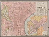
Philadelphia and vicinity. and Rand McNally & Co.'s new business atlas map of Philadelphia.
Description:
"90, 91.", At head of title and top of map: Rand McNally & Co.'s indexed Atlas of the world., Includes index of piers and their ownership on Delaware River., Inset: Philadelphia and vicinity. Scale [ca. 1:120,000]., and On verso: [part of gazetteer listing for Pe
Publisher:
Rand McNally,
Subject (Geographic):
Philadelphia (Pa.)--Maps and Philadelphia Metropolitan Area (Pa.)--Maps
Subject (Name):
Rand McNally and Company. Rand McNally & Co.'s indexed atlas of the world
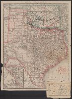
Rand, McNally & Co.'s Texas and Indian Territory and Texas and the Indian Territory
Description:
Includes map of western portion of Texas., Library's copy annotated in red ink and blue pencil., Library's copy attached to map showing, Prime meridians: Greenwich and Washington., Relief shown by hachures., and Shows county outlines, county seats, and railroads.
Publisher:
Rand, McNally & Co.,
Subject (Geographic):
Indian Territory--Maps, Texas--Administrative and political divisions--Maps, and Texas--Maps
Subject (Topic):
Railroads--Indian Territory--Maps, Railroads--Texas--Denison--Maps, and Railroads--Texas--Maps
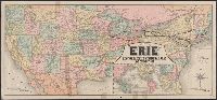
"Jno. B. Loveland, Gen'l European Passenger Agent, Liverpool, England.", "Martin B. Brown, Railroad Printer, 49 & 51 Park Place, New York.", Includes text and timetables on verso., Inset: Around the world, across the American continent via Erie Railway., and Show
Publisher:
Rand, McNally & Co.,
Subject (Name):
New York, Lake Erie, and Western Railroad Company and New York, Lake Erie, and Western Railroad Company--Maps
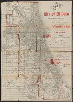
"For 'The standard guide to Chicago.'", "This map also shows the sites selected for the World's Columbian Exposition of 1893.", Caption title., and Imperfect: sheet torn along folds and separated into two pieces.
Publisher:
Rand McNally & Co.,
Subject (Geographic):
Chicago (Ill.)--Maps
Subject (Name):
Flinn, John J. (John Joseph), 1851-1929. Standard guide to Chicago and World's Columbian Exposition--(1893 :--Chicago, Ill.)--Maps
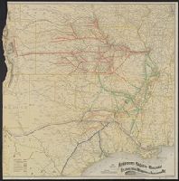
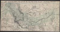
Map of Northern Pacific R.R. and Oregon Railway & Navigation Co., showing land grant., Map showing Northern Pacific Railroad system., Northern Pacific land grant map of Montana, and Preserve this Montana map, it shows the land grant of the Northern Pacific Railr
Description:
Date inferred from fare and freight rates "in effect Aug. 1, 1889," on verso., Includes inset with 2 titles, "Map showing Northern Pacific Railroad system" and "Map of Northern Pacific R.R. and Oregon Railway & Navigation Co., showing land grant.", and Relief shown by hachures.
Publisher:
Rand McNally & Co.,
Subject (Name):
Northern Pacific Railroad Company--Maps
Subject (Topic):
Railroad land grants--Northwest, Pacific--Maps and Railroads--Northwest, Pacific--Maps
Indexed atlas of the world map of Mexico and Rand, McNally & Co.'s indexed atlas of the world map of Mexico
Description:
Includes "Map of the Valley of Mexico." Scale ca. [1:400,000]., On verso: Plan of the city of Mexico. Scale [ca. 1:16,000] -- Valley of Mexico. Scale [ca. 1:172,000]., Relief shown by hachures and spot heights., and Shows railroads.