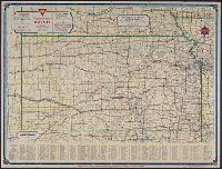
Conoco official road map of Kansas, Kansas, and Travel Kansas with Conoco
Description:
"333-J.C. 10-L" and "1381.", 9 local route maps, text, and ill. on verso., At head of title: Conoco., Includes index and population statistics., and Relief shown by spot heights.
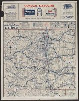
Auto trails map of Colorado, Auto trails map, Denver and vicinity., Official 1924, auto trails map of Colorado, and Rand McNally detailed auto trails map, Denver and vicinity.
Description:
Distributed by the Continental Oil Company., On verso: Rand McNally detailed auto trails map, Denver and vicinity. Scale [ca. 1:500,000]., Relief shown by hachures and spot heights., and Shows trail and highway markings.
Publisher:
Rand McNally & Company,
Subject (Geographic):
Colorado--Maps
Subject (Name):
Continental Oil Company
Subject (Topic):
Roads--Colorado--Denver Region--Maps and Roads--Colorado--Maps
"Rand McNally road map, United States" (scale [ca. 1:10,200,960], 1 in. = approx. 161 miles), text, and distance table on verso., Copyright: Rand McNally & Company., In lower right: 1-463629V-7., Includes mileage chart and index., and Relief shown pictorially and by spot heights.
Publisher:
The Company,
Subject (Geographic):
California--Maps
Subject (Name):
Randall Motor Club
Subject (Topic):
Roads--California--Maps and Roads--United States--Maps
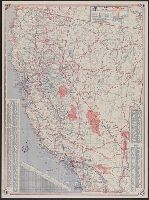
"Prepared for Standard Oil Company of California.", In lower left: 11-HH-286-S., Includes index to cities and towns, and ill. index of points of interest., Mileage chart and 4 ancillary maps on verso., and Relief shown by hachures and spot heights.
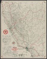
1931 Texaco road map, California, Nevada, Road map, California, Nevada, and Texaco road map, 1931, United States.
Description:
At head of title: 1931., Index, ill., and road maps of United States, Oakland area, Los Angeles and vicinity, and San Francisco area on verso., Insets: Map of Yosemite National Park -- Map of Sequoia & Gen. Grant national parks., and Relief shown by hachures and spot heights.
Publisher:
Rand McNally,
Subject (Geographic):
California--Maps and Nevada--Maps
Subject (Name):
Texas Company
Subject (Topic):
Roads--California--Maps, Roads--Nevada--Maps, and Roads--United States--Maps
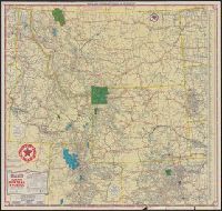
Idaho, Montana, Wyoming, and North & South Dakota, Texaco road map, Idaho, Montana, Wyoming., and Texaco road map, North Dakota, South Dakota.
Description:
"S.2721.", "S.3227.", Includes indexes, text, ill., and maps of "Yellowstone National Park" and "Waterton-Glacier International Peace Park.", Panel title., Relief shown by hachures and spot heights., and Texaco road map, Idaho, Montana, Wyoming -- Texaco road map, North Dakota, South Dakota.
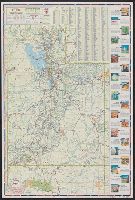
New commercial atlas map of Utah and Utah automobile road map.
Description:
"Utah automobile road map" (scale [ca. 1:965,485]) and advertisement on verso., In lower right margin: 253c., Indexed., Relief shown by hachures., and Shows railroads and counties.