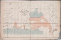
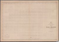
[Maury map collection ; ser. F5] and Sperm and right whale
Description:
"By authority of Commo: Charles Morris U.S.N., Chief of Bureau of Ordnance and Hydrography, 1853.", "Series F.", Copy imperfect: Sectioned vertically in half, sections mounted on cloth to form 1 sheet., DLC, and The whale chart was released as series F a part of
Publisher:
United States Hydrographical Office,
Subject (Name):
Endicott & Co. (New York, N.Y.), Maury, Matthew Fontaine, 1806-1873. Wind and current charts, Morris, Charles, 1784-1856, United States. Bureau of Ordnance and Hydrography, United States. Hydrographic Office, and Wyman, R. H. (Robert Harris), 1822-1882
Subject (Topic):
Right whales--Maps, Sperm whale--Maps, Whales--Behavior--Maps, and Whaling--Maps
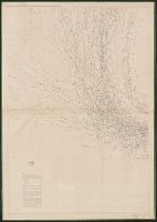
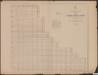
[Maury map collection ; Series A5], South Pacific, Wind and current chart of the South Pacific, and Wind and current chart, South Pacific
Description:
"[Engraved by] Oliver J. Stuart. N.Y."--Sheet 8, lower right margin., "Eng. by Sherman & Smith N.Y."--Sheet 10, lower right margin., Shows prevailing wind direction by month., and Similar wind and current charts of other oceans compiled from materials in the Bur
Publisher:
United States Hydrographical Office,
Subject (Geographic):
South Pacific Ocean--Charts, diagrams, etc
Subject (Name):
Gibbon, Lardner, Maury, Matthew Fontaine, 1806-1873. Wind and current charts, Sherman & Smith, Stuart, Oliver J, United States Naval Observatory, United States. Bureau of Ordnance and Hydrography, United States. Hydrographic Office, and Wells, C. H
[Maury map collection ; Series A5], South Pacific, Wind and current chart of the South Pacific, and Wind and current chart, South Pacific
Description:
"[Engraved by] Oliver J. Stuart. N.Y."--Sheet 8, lower right margin., "Eng. by Sherman & Smith N.Y."--Sheet 10, lower right margin., DLC, Includes, Shows prevailing wind direction by month., and Various eds. of some sheets with updated and additional information.
Publisher:
United States Hydrographical Office,
Subject (Geographic):
South Pacific Ocean--Charts, diagrams, etc
Subject (Name):
Gibbon, Lardner, Maury, Matthew Fontaine, 1806-1873. Wind and current charts, Sherman & Smith, Stuart, Oliver J, United States Naval Observatory, United States. Bureau of Ordnance and Hydrography, United States. Hydrographic Office, and Wells, C. H
"Series C." and The pilot charts were released as series C of Maury's "Wind and current charts", series A-F. These charts were designed for sailing ships and recorded wind direction observations made by mariners on previous voyages. For complete discussion, s
Publisher:
United States Hydrographical Office,
Subject (Geographic):
North Atlantic Ocean--Maps
Subject (Name):
Brooke, John M. (John Mercer), 1826-1906, McClelland, D, United States. Bureau of Ordnance and Hydrography, and United States. Hydrographic Office
Subject (Topic):
Nautical charts--North Atlantic Ocean and Winds--North Atlantic Ocean--Maps
The pilot charts were released as series C of Maury's "Wind and current charts", series A-F. These charts were designed for sailing ships and recorded wind direction observations made by mariners on previous voyages. For complete discussion, see "The wind
Publisher:
United States Hydrographical Office,
Subject (Geographic):
Indian Ocean--Maps
Subject (Name):
Carter, J. H, Guthrie, John Julien, United States. Bureau of Ordnance and Hydrography, United States. Hydrographic Office, and West, Wm. C. (William C.)
Subject (Topic):
Nautical charts--Indian Ocean and Winds--Indian Ocean--Maps
"Series E.", "Under the head of rain are included Hail, Snow and Sleet."--Explanation., and The storm and rain charts were released as series E of Maury's "Wind and current charts", series A-F. For complete discussion, see "The wind and current chart series pro
Publisher:
United States Hydrographical Office,
Subject (Geographic):
North Atlantic Ocean--Climate--Maps and North Atlantic Ocean--Maps
Subject (Name):
Ball, William H, Minor, George, Sherman & Smith, Taylor, W. Rodgers, United States. Bureau of Ordnance and Hydrography, and United States. Hydrographic Office
Covers the northeastern Pacific only., It appears that this chart was intended to be complete in 2 sheets, but only sheet 1 was issued., and The storm and rain charts were released as series E of Maury's "Wind and current charts", series A-F. For complete discu
Publisher:
United States Hydrographical Office,
Subject (Geographic):
North Pacific Ocean--Climate--Maps and North Pacific Ocean--Maps
Subject (Name):
Johnston, James D, United States. Bureau of Ordnance and Hydrography, United States. Hydrographic Office, and Warley, Alexander F., 1823-1895
"Under the head of Rains are included Hail, Snow and Sleet."--Explanation. and The storm and rain charts were released as series E of Maury's "Wind and current charts", series A-F. For complete discussion, see "The wind and current chart series produced by Ma
Publisher:
United States Hydrographical Office,
Subject (Geographic):
South Atlantic Ocean--Climate--Maps and South Atlantic Ocean--Maps
Subject (Name):
Beaumont, John C, Forrest, Dulany A, Guthrie, John Julien, United States. Bureau of Ordnance and Hydrography, and United States. Hydrographic Office
[Maury map collection ; ser. A2], Maury's wind & current chart, S. Atlantic, Maury's wind & current chart, South Atlantic, Maury's wind and current chart, series A, South Atlantic, Maury's wind and current chart, South Atlantic, and South Atlantic
Description:
"Series A.", Copy imperfect: All sheets torn and repaired along, Does not cover the southeastern Atlantic south of latitude 40° S., Includes notes., Shows prevailing wind direction by month., and Various eds. of some sheets with updated and additional information.
Publisher:
United States Hydrographical Office,
Subject (Geographic):
South Atlantic Ocean--Charts, diagrams, etc
Subject (Name):
Flye, Wm, Maury, Matthew Fontaine, 1806-1873. Wind and current charts, Sherman & Smith, Temple, William G. (William Grenville), 1824-1894, United States Naval Observatory, United States. Bureau of Ordnance and Hydrography, and United States. Hydrographic Office
[Maury map collection ; ser. A2], Maury's wind & current chart, S. Atlantic, Maury's wind & current chart, South Atlantic, Maury's wind and current chart, series A, South Atlantic, Maury's wind and current chart, South Atlantic, and South Atlantic
Description:
"Series A.", DLC, Includes notes., Sheet 1 (1853) -- Sheet 2 (no date) -- Sheet 3 (no date) -- Sheet 3 (Updated) -- Sheet 4 (no date), 2 copies., Sheets individually numbered, e.g.: Series A. No. 1., and Various eds. of some sheets with updated and additional info
Publisher:
United States Hydrographical Office,
Subject (Geographic):
South Atlantic Ocean--Charts, diagrams, etc
Subject (Name):
Flye, Wm, Maury, Matthew Fontaine, 1806-1873. Wind and current charts, Sherman & Smith, Temple, William G. (William Grenville), 1824-1894, United States Naval Observatory, United States. Bureau of Ordnance and Hydrography, and United States. Hydrographic Office