Skip to search
Skip to main content
Skip to first result
Search
You Searched For
Date
Unknown
Format
cartographic
Creator
Jefferys, Thomas, d. 1771
Date Created
[Missing]
New Search
Search Results
Creator:
Call Number:
Z6 70
Collection Title:
An enquiry into the causes of the alienation of the Delaware and Shawanese Indians from the British
Image Count:
1
Description:
Preceding title page. and Teaching resource: Professor John Mack Faragher, History 141: The American West.
Subject (Topic):
Delaware Indians, Indians of North America --Pennsylvania --Treaties, and Shawnee Indians
Collection Created:
London, Printed for J. Wilkie, 1759
Found in:
Beinecke Rare Book and Manuscript Library > A map of the province of Pensylvania. intended chiefly to illustrate the account of the several Indian purchases made by the proprietaries of the said province the claims made by the Indians, on lands settled and not purchased of them and the tract they n
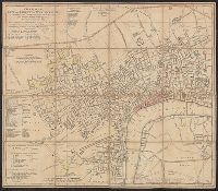
Creator:
Call Number:
32 L84 1766
Container / Volume:
BRBL_00048
Image Count:
1
Resource Type:
Maps, Atlases & Globes
Subject (Geographic):
London (England)--Maps--Early works to 1800 and Westminster (London, England)--Maps--Early works to 1800
Found in:
Beinecke Rare Book and Manuscript Library > A new plan of the city and liberty of Westminster ... / drawn & engraved by Thomas Jefferys ...
Creator:
Call Number:
C6 033c
Collection Title:
The natural and civil history of the French dominions in North and South America : with an
Image Count:
1
Resource Type:
Maps, Atlases & Globes
Description:
Plate between p. 68-9.
Subject (Geographic):
Atlantic Ocean--Charts, maps, etc., Atlantic Ocean--Maps--Early works to 1800, and Santo Domingo (Dominican Republic)
Collection Created:
London, Printed for T. Jeffreys, 1761
Found in:
Beinecke Rare Book and Manuscript Library > An authentic plan of the town and harbour of Cap Francois in the isle of St. Domingo. By Thomas Jefferys geographer to his Royal Highness the Prince of Wales
Creator:
Call Number:
1977 Folio 96
Collection Title:
The West-India atlas: or, A compendious description of the West-Indies: illustrated with forty
Image Count:
1
Resource Type:
Maps, Atlases & Globes
Subject (Geographic):
Jamaica
Subject (Topic):
Nautical charts
Collection Created:
London, Printed for Robert Sayer and John Bennett, Fleet-Street, 1775
Found in:
Beinecke Rare Book and Manuscript Library > Jamaica from the latest surveys; improved and engraved by Thomas Jefferys geographer to the king
Creator:
Call Number:
1977 Folio 96
Collection Title:
The West-India atlas: or, A compendious description of the West-Indies: illustrated with forty
Image Count:
1
Resource Type:
Maps, Atlases & Globes
Subject (Geographic):
Hispaniola
Subject (Topic):
Nautical charts
Collection Created:
London, Printed for Robert Sayer and John Bennett, Fleet-Street, 1775
Found in:
Beinecke Rare Book and Manuscript Library > South part of St. Domingo, of Hispaniola, by Thos Jeffreys geographer to his Majesty
Creator:
Call Number:
1977 Folio 96
Collection Title:
The West-India atlas: or, A compendious description of the West-Indies: illustrated with forty
Image Count:
1
Resource Type:
Maps, Atlases & Globes
Alternative Title:
The harbours of Kingston and Port Royal and The windward passage, with the several passages, from the...east end of Cuba, and the north part of St. Domingo.
Description:
With two inset maps.
Subject (Geographic):
Cuba. and Santo Domingo (Dominican Republic)
Subject (Topic):
Nautical charts
Collection Created:
London, Printed for Robert Sayer and John Bennett, Fleet-Street, 1775
Found in:
Beinecke Rare Book and Manuscript Library > The harbour of Bluefields.
Creator:
Call Number:
C6 033c
Collection Title:
The natural and civil history of the French dominions in North and South America : with an
Image Count:
1
Resource Type:
Maps, Atlases & Globes
Description:
Plate between p. 2-3.
Subject (Geographic):
Atlantic Ocean--Charts, maps, etc., Atlantic Ocean--Maps--Early works to 1800, and Santo Domingo (Dominican Republic)
Collection Created:
London, Printed for T. Jeffreys, 1761
Found in:
Beinecke Rare Book and Manuscript Library > The island of Hispaniola called by the French St. Domingo. Subject to France and Spain. from the best authorities by Thomas Jeffreys, geographer to his Royal Highness the Prince of Wales
Branch:v1.61.6 ,Deployed:2024-06-12T09:55:19-04:00