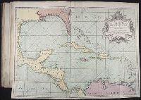
Cruz Cano y Olmedilla, Juan de la, d. 1790 Lopez de Vargas Machuca, Tomas, 1731-1802, creator
Published / Created:
1755
Call Number:
2003 Folio 85
Image Count:
1
Description:
Available also through the Library of Congress Web site as a raster image., BEIN 2003 Folio 85: No. 27 of 45 maps bound together with binder's spine title: Atlas of America; ms. table of contents. Bookplate: Robinson. Bookplate of Paul Mellon., Dedicado a la Catholica Magestad de Don Fernando VI Rey de Espana, y de las Yndias, por sus mas rendidos, y fieles vasallos, Thomas Lopez, y Juan de la Cruz., Depths shown by soundings., Hand colored., LC Maps of North America, 1750-1789,, Longitud ocidental del meridiano de Tenerife., and Scale [ca. 1:5,500,000].
Subject (Geographic):
Caribbean Area -- Maps -- Early works to 1800
Subject (Topic):
Nautical charts -- Caribbean Area -- Early works to 1800
North America --Maps, United States --Politics and government, and United States --Social conditions
Subject (Name):
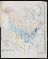
Sanchez de Bustamante, D. A
Subject (Topic):
Democracy
Collection Created:
De la democracia en la America del Norte / por Alejo de Tocqueville, abogado de la real audiencia de Paris ; traducida de la cuarta edicion por D.A. Sanchez de Bustamente
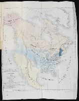
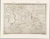
Manuscript map, in color, drawn by Bernardo Miera y Pacheco in San Felipe, Chihuahua, Mexico, in 1778. It reveals Spain's northernmost efforts to explore the interior of western North America on the Domínguez-Escalante Expedition, including present day New Mexico, Colorado, Utah, and Arizona.
Description:
Bernardo Miera y Pacheco was the cartographer on the Domínguez-Escalante Expedition. The expedition of ten men, led by Franciscan Fathers Francisco Atanasio Domínguez and Silvestre Vélez de Escalante, departed Sante Fe in late July 1776 and returned there on 2 January 1777., Note in later hand at upper edge of map: "Map of New Mexico with the latest discoveries.", and Scale [ca. 1:3,250,000] (W 112⁰ W 105⁰/N 40⁰ N 34⁰). Bar scale given in "leguas reguladas las marchas por tierra." Coordinates on map as: W260 W273/N42 N35.
Subject (Geographic):
Arizona--Maps--Early works to 1800, Colorado--Maps--Early works to 1800, New Mexico--Maps--Early works to 1800, Southwest, New--Maps--Early works to 1800, and Utah--Maps--Early works to 1800
Subject (Name):
Domínguez, Francisco Atanasio, active 1776, Domínguez-Escalante Expedition (1776), Miera y Pacheco, Bernardo de, and Vélez de Escalante, Silvestre, -1792
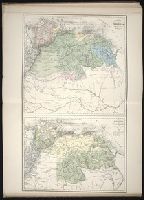
Homann Erben (Firm) Homann, Johann Baptist, 1663-1724
Published / Created:
1728?
Call Number:
1973 Folio 30
Collection Title:
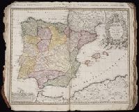
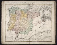
[Atlas factice of 32 maps and 1 distance table, produced by the Homann Erben firm]
Image Count:
3
Alternative Title:
Regnorum Hispaniae et Portugalliae tabula generalis de l’Isliana and Reyno de Espanna dividido en dos grandes estados de Aragon y de Castilla, subdividido en muchas provincias donde se halla tambien el Reyno de Portugal
Publisher:
[Homann Erben]
Subject (Geographic):
Portugal --Maps --Early works to 1800 and Spain --Maps --Early works to 1800