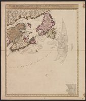
Carte nouvelle contenant la partie d'Amerique la plus septentrionale : ou sont exactement dêcrites les provinces suivantes comme le Canada ou Nouvelle France, la Nouvelle Ecosse, la Nouvelle Angleterre, les Nouveaux Paı̈s Bas, la Pensylvanie, la Virginie
Description:
"Cum privilegio ordinum generalium foederati Belgii.", Appears in some eds. of the author's Atlas minor sive geographia compendiosa., Library copy incomplete, Atlantic Canada sheet only; damaged in upper left., and Relief shown pictorially. Depths shown by sound
Publisher:
Nicolao Visscher,
Subject (Geographic):
Atlantic Provinces--Maps--Early works to 1800 and North America--Maps--Early works to 1800
Subject (Name):
Anse, Luggert van, fl. 1690-1716, engraver and Visscher, Nicolaes, 1649-1702. Atlas minor sive geographia compendiosa
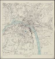
"Brevet n. 458-412.", Includes list of stations and "directions of using = clef" in English and French., Includes pictorial representation of Grands Magasins du Louvre department store., and Shows stations, Métro lines, and piers.
Publisher:
s.n.,
Subject (Geographic):
Paris (France)--Maps
Subject (Name):
Grands Magasins du Louvre and Grands Magasins du Louvre--Maps
Subject (Topic):
Buses--France--Paris--Maps and Street-railroads--France--Paris--Maps
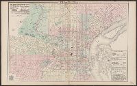
Describes location of steam railroad passenger depots., From Gray's atlas, p. 60-61., Legend in English, French and German., and Shows steam and horse railroads, wards, parks, etc.
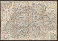
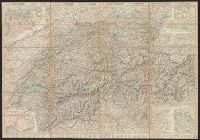
"Nr. 6210 BRB. 3.X.39"., Relief shown by shading, contours, and spot heights., and Text, illus., directory of mountain passes, and location map on verso.
Carta stradale della Svizzera, Carte routière de la Suisse, Reisekarte der Schweiz, and Road map of Switzerland
Description:
In French. Legend and scales in French, English, German, and Italian., Includes insets of northwestern Europe, north-central Europe, northern Italy, and the French-Italian coastal, and Mounted on verso: Luzern -- Bâle -- Genève -- Zuric -- Berne -- Lausanne.
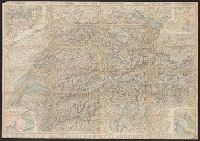
Carta stradale della Svizzera, Carte routière de la Suisse, Reisekarte der Schweiz, and Road map of Switzerland
Description:
In French. Legend and scales in French, English, German, and Italian., Includes insets of northwestern Europe, north-central Europe, northern Italy, and the French-Italian coastal region., Mounted on verso: Luzern, and Relief shown by hachures and spot heights.
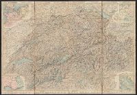
Carta stradale della Svizzera, Carte routière de la Suisse, Reisekarte der Schweiz, and Road map of Switzerland
Description:
In French. Legend and scales in French, English, German, and Italian., Includes insets of northwestern Europe, north-central Europe, northern Italy, and the French-Italian coastal region., Library copy annotated in, and Relief shown by hachures and spot heights.
Carta stradale della Svizzera, Carte routière de la Suisse, Reisekarte der Schweiz, and Road map of Switzerland
Description:
In French. Legend and scales in French, English, German, and Italian., Includes insets of northwestern Europe, north-central Europe, northern Italy, and the French-Italian coastal region., and Mounted on verso: Luzern -- Bâle -- Genève -- Zuric -- Berne -- La
"3-43.", "Copied from a French map, 1:10,000, Plan de la ville de Rouen, 1933.", "First edition 1943.", Most streets and some buildings are named., Nord de guerre zone grid., and Street names and some points of interest in French.