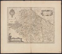
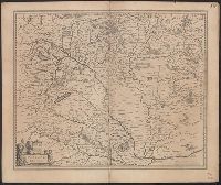
Bar scale given in "milliaria Gallica"., In Latin on verso with caption title "Regio Gast. et Hurep." and signature K., Prime meridian: Ferro., Relief shown pictorially., and Sheet measures 56.0 x 64.1 cm.
Publisher:
Excud. Guiljelmus Blaeu,
Subject (Geographic):
Burgundy (France)--Maps--Early works to 1800, Centre (France)--Maps--Early works to 1800, and Île-de-France (France)--Maps--Early works to 1800
From Willem and Joan Blaeu's Theatrum orbis terrarum. Amsterdami : Apud Guiljelmum et Iohannem Blaeu, 1635., Signature on verso: I., and Title on verso: Granata & Murcia.
Publisher:
Blaeu,
Subject (Geographic):
Granada (Spain : Province)--Maps--Early works to 1800 and Murcia (Spain : Region)--Maps--Early works to 1800
Gviana siue Amazonvm regio and Gviana sive Amazonvm regio
Description:
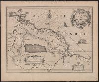
Bar scales in "Milliaria Germanica communia" and "Milliaria Gallica communia.", Blank on verso., From Blaeu's Atlantis appendix ... Amsterdami : Apud Guiljelmum Blaeu, 1630., Mounted on linen. Sheet measures 45.2 x 55.4 cm., and Relief shown pictorially.
Publisher:
Guiljelmus Blaeuw excudit,
Subject (Geographic):
Guyana--Maps--Early works to 1800
Subject (Name):
Blaeu, Willem Janszoon, 1571-1638. Atlantis appendix
Gviana siue Amazonvm regio and Gviana sive Amazonvm regio
Description:
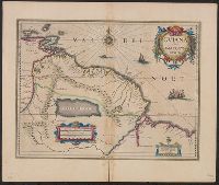
Bar scales in "Milliari, From Willem Janszoon and Joan Blaeu's Le theatre du monde ... Amsterdami : Apud Guiljelmum et Iohannem Blaeu, 1635., Imperfect: split along fold, with no loss of text. Hand col. Sheet measures 47.8 x 57 cm., and Relief shown pictorially.
Publisher:
Guiljelmus Blaeuw excudit,
Subject (Geographic):
Guyana--Maps--Early works to 1800
Subject (Name):
Blaeu, Joan, 1596-1673. Theatrum orbis terrarum. French and Blaeu, Willem Janszoon, 1571-1638. Theatrum orbis terrarum. French
Gviana siue Amazonvm regio and Gviana sive Amazonvm regio
Description:
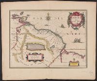
Cross Collection no. 337., From Willem Janszoon and Joan Blaeu's Theatrum orbis terrarum ... Amsterdami : Apud Ioh. & Cornelium Blaeu, 1640., Hand col., and In Latin on verso, with caption title "Guiana sive regio Amazonum" and signature P.
Publisher:
Guiljelmus Blaeuw excudit,
Subject (Geographic):
Guyana--Maps--Early works to 1800
Subject (Name):
Blaeu, Joan, 1596-1673. Theatrum orbis terrarum and Blaeu, Willem Janszoon, 1571-1638. Theatrum orbis terrarum
Blaeu, Willem Janszoon, 1571-1638 Hortensius, Martinus, 1605-1639
Published / Created:
Anno Dom. 1665.
Call Number:
QB41 B52 1665
Image Count:
206
Description:
Madan 2694 (not seen); presumably a reissue of the 1663 edition (Madan 2632, also not seen), with a new cancelling title page., Signatures: [a]1A-Aa8., and Title-page in two states, cancelling (1st preliminary leaf) and cancelled (2nd preliminary leaf; lower outer corner, including imprint-date [1663?], missing).
Publisher:
Excudebat W. Hall impensis Joh. Forrest,
Subject (Name):
Copernicus, Nicolaus, 1473-1543 and Ptolemy, 2nd cent.
Bar scale given in "milliaria Hungarica communia"., From Willem and Joan Blaeu's Theatrum orbis terrarum (1635)., Imperfect: sheet torn along fold, with some loss of text. Ms. no. on verso: j28. Sheet measures 48.0 x 57.3 cm., In La, and Relief shown pictorially.
Publisher:
Apud Guiljelmum et Johannem Blaeu,
Subject (Geographic):
Hungary--Maps--Early works to 1800
Subject (Name):
Blaeu, Joan, 1596-1673. Theatrum orbis terrarum and Blaeu, Willem Janszoon, 1571-1638. Theatrum orbis terrarum
Insulae Americanae in Oceano Septentrionali cum terris adjacentibus and Insvlae Americanae in Oceano Septentrionali cum terris adiacentibus
Description:
Cf. Burden, P.D. Mapping of North America, 242., Cf. Koeman, C. Atlantes Neerlandici (1997 ed.), II, p. 600 (map 9600:2B)., Includes dedication to "D. Alberto Conradi Vander Burch" signed "tabulam hanc inscribit Guiljelmus Blaeu.", Includes embellished title cartouche, dedication with coats-of-arms, scale and ill. of ships at sea., and Includes scales in milliaria germanica and milliaria hispanica.
Publisher:
s.n.,
Subject (Geographic):
Caribbean Area--Maps--Early works to 1800, Mexico, Gulf of--Maps--Early works to 1800, and West Indies--Maps--Early works to 1800
Subject (Topic):
Coasts--North America--Maps--Early works to 1800 and Coasts--South America--Maps--Early works to 1800