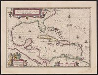
Insulae Americanae in Oceano Septentrionali cum terris adjacentibus and Insvlae Americanae in Oceano Septentrionali cum terris adiacentibus
Description:
Includes ded, Sheet measures 45.8 x 59.8 cm. Cross Collection no. 228., and Text in Latin on verso with caption title "Insulae americanae in oceano septemtrionali, ante sinum mexicanum, & aliquot continentis regiones," title at foot "America," and signature D3.
Publisher:
s.n.,
Subject (Geographic):
Caribbean Area--Maps--Early works to 1800, Mexico, Gulf of--Maps--Early works to 1800, and West Indies--Maps--Early works to 1800
Subject (Name):
Blaeu, Joan, 1596-1673. Theatrum orbis terrarum and Blaeu, Willem Janszoon, 1571-1638. Theatrum orbis terrarum
Subject (Topic):
Coasts--North America--Maps--Early works to 1800 and Coasts--South America--Maps--Early works to 1800
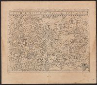
Bar scale given in "milliaria Gallica"., Imperfect: sheet torn on left side, with no loss of text. Sheet measures 50.5 x, In Latin on verso, with caption title "Languedocia, vulgo Languedoc" and signature H., Prime meridian: Ferro., and Relief shown pictorially.
Bar scales given in "miliaria Germanica" and "milliaria Gallica"., Caption title., From the 1635 Latin ed. of Willem and Joan Blaeu's Theatrum orbis terrarum., In Latin on verso; with signature 2L., Includes coat of arms., Oriented with north to the right., and Rel
Publisher:
Apud Guiljelmum Blaeuw,
Subject (Geographic):
Lorraine (France)--Maps--Early works to 1800
Subject (Name):
Blaeu, Joan, 1596-1673. Theatrum orbis terrarum and Blaeu, Willem Janszoon, 1571-1638. Theatrum orbis terrarum
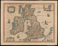
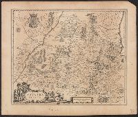
Bar scales given in "milliaria Anglica communia," "milliaria Anglica parva," and "milliaria Germanica communia.", From Joan Blaeu's Latin edition of Theatrum orbis terrarum (1648)., In Latin on verso, with caption title "Britannia," signature A, and paginated 1-2., Relief shown pictorially., Watermark., and With inset map "Orcades insulae."
Subject (Geographic):
Great Britain--Maps--Early works to 1800.
Subject (Name):
Blaeu, Joan, 1596-1673 and Blaeu, Joan, 1596-1673. Theatrum orbis terrarum.
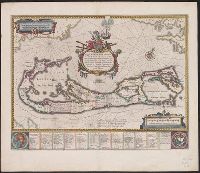
Mappa Aestivarvm insularum, alias Barmvdas dictarum
Description:
Based on Speed's map of 1626 but with new decorations., Below map, list of proprietors in 12 columns with arms of England and Bermuda., From the author's Theatre du monde ou nouvel atlas., Latin and English text on recto and French text on verso., Signature on verso: G., and Title on verso: L'Isle de Barmudas, avec ses voysines.
Publisher:
[Guillaume et Iean Blaeu,
Subject (Geographic):
Bermuda Islands--Maps--Early works to 1800
Subject (Name):
Blaeu, Joan, 1596-1673. Theatrum orbis terrarum. French and Blaeu, Willem Janszoon, 1571-1638. Theatrum orbis terrarum. French
First instance of beavers, polecats and otters appearing on a printed map (Burde, Mounted on linen. Sheet measures 45.5 x 56 cm. Stamp on verso: Yale University Library Karpinksi-von Wieser Map Collection., Oriented west., and Relief shown pictorially.
Publisher:
s.n.,
Subject (Geographic):
Middle Atlantic States--Maps--Early works to 1800 and New England--Maps--Early works to 1800
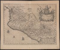
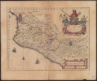
Appears in Blaeu's Le grand atlas, ou, Cosmographie blauiane., Bar scale given in "milliaria Hispanica.", Includes "Notarum explanatio" and ill., Ms. no. in pencil on verso: 94., and Relief shown pictorially.
Bar scale given in "milliaria Hispanica.", Cross Collection no. 311., From Blaeu's Le theatre du monde ... Amsterdami : Apud Guiljelmum et Iohannem Blaeu, 1635., Imperfect: torn half-way along fold., In French on verso, with caption title "La novvelle Espagne" and signature C6., Includes "Notarum explanatio" and ill., and Relief shown pictorially.
Publisher:
Willem and Joan Blaeu,
Subject (Geographic):
Mexico--Maps--Early works to 1800
Subject (Name):
Blaeu, Joan, 1596-1673. Theatrum orbis terrarum. French and Blaeu, Willem Janszoon, 1571-1638. Theatrum orbis terrarum. French
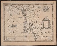
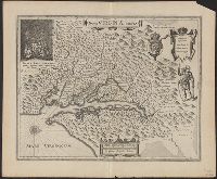
From Willem Janszoon Blaeu's Atlantis appendix ... Amsterdami : Apud Guiljelmum Blaeuw, 1630., Oriented west., Relief shown pictorially., Sheet measures 45.2 x 54.8 cm., and Upper left: Portait of Powhatan with subtitle: Status regis Powhatan quando pr
Publisher:
Ex Officina Guiljelmi Blaeuw,
Subject (Geographic):
Chesapeake Bay Region (Md. and Va.)--Maps--Early works to 1800, Maryland--Maps--Early works to 1800, and Virginia--Maps--Early works to 1800
Subject (Name):
Blaeu, Willem Janszoon, 1571-1638. Atlantis appendix, Gryp, Dirck, engraver, Powhatan, ca. 1550-1618, and Smith, John, 1580-1631
Subject (Topic):
Powhatan Indians--Pictorial works--Early works to 1800