Skip to search
Skip to main content
Skip to first result
Search
You Searched For
Format
cartographic
Publication Place
London :
New Search
Search Results
Published / Created:
1809
Call Number:
56 1809
Container / Volume:
BRBL_00295
Image Count:
1
Resource Type:
Maps, Atlases & Globes
Description:
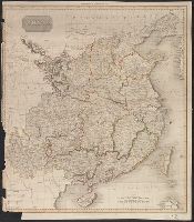
From Pinkerton's Modern Atlas.
Publisher:
Cadell & Davies,
Subject (Geographic):
China--Maps
Found in:
Beinecke Rare Book and Manuscript Library > China. Neele Sculpt.
Published / Created:
1959
Call Number:
32fb L84 1907
Container / Volume:
BRBL_00075
Image Count:
1
Resource Type:
Maps, Atlases & Globes
Description:
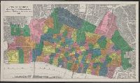
Reproduced for the London Topographical Society from the 1:2500 Ordnance Survey map, 1st ed., 1878.
Publisher:
Edward Stanford Ltd.,
Subject (Geographic):
London (England)--Description and travel--Maps and London (England)--Maps
Subject (Name):
London Topographical Society
Found in:
Beinecke Rare Book and Manuscript Library > City of London showing parish boundaries prior to the Union of Parishes Act, 1907 [cartographic material].
Creator:
Published / Created:
[1883?]
Call Number:
352 Sa25 1883
Container / Volume:
BRBL_00108
Image Count:
1
Resource Type:
Maps, Atlases & Globes
Alternative Title:
City of Saint Petersburg and Letts's popular atlas.
Description:
In bottom right: 70., In top margin: Letts's popular atlas., and Indexed.
Publisher:
Letts, Son & Co.,
Subject (Geographic):
Saint Petersburg (Russia)--Maps
Found in:
Beinecke Rare Book and Manuscript Library > City of St. Petersburg.
Creator:
Published / Created:
1905
Call Number:
32 L84 1570/1905
Container / Volume:
BRBL_00737
Image Count:
8
Resource Type:
Maps, Atlases & Globes
Alternative Title:
Plan of London (circa 1560-1570) by Ralph Agas
Description:
Bird's-eye-view., Includes ill., text and coats-of-arms., and Relief shown pictorially.
Publisher:
London Topographical Society,
Subject (Geographic):
London (England)--Aerial views--Early works to 1800--Facsimiles
Subject (Name):
London Topographical Society
Found in:
Beinecke Rare Book and Manuscript Library > Civitas Londinum.
Published / Created:
[1854?]
Call Number:
35311hc Se21 1854A
Container / Volume:
BRBL_00112
Image Count:
1
Resource Type:
Maps, Atlases & Globes
Alternative Title:
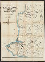
Environs of Sebastopol
Publisher:
Published by Boell Lewis & Co., and Published by H.C. Collins ;
Subject (Geographic):
Sevastopolʹ (Ukraine)--History--Siege, 1854-1855--Maps
Subject (Topic):
Crimean War, 1853-1856--Campaigns--Ukraine--Maps
Found in:
Beinecke Rare Book and Manuscript Library > Collins' environs of Sebastopol : showing the position of the investing armies and also the plan of the Battle-field of Alma / drawn from the most recent surveys by F. Raverstow.
Creator:
Published / Created:
[1860?]
Call Number:
3226 1860
Container / Volume:
BRBL_00061
Image Count:
2
Resource Type:
Maps, Atlases & Globes
Alternative Title:
Collins' railway & telegraph map of Devonshire. and Railway and telegraph map of Devonshire.
Description:
Includes index of hundreds. and Relief shown by hachures.
Publisher:
Henry George Collins,
Subject (Geographic):
Devon (England)--Administrative and political divisions--Maps
Subject (Topic):
Railroads--England--Devon--Maps and Telegraph--England--Devon--Maps
Found in:
Beinecke Rare Book and Manuscript Library > Collins' railway and telegraph map of Devonshire : divided into hundreds, containing the district divisions and other local arrangements effected by the Reform Bill.
Creator:
Published / Created:
[1877?].
Call Number:
32 L84 1877
Container / Volume:
BRBL_00051
Image Count:
1
Resource Type:
Maps, Atlases & Globes
Description:
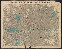
"This map is divided into squar, 32 L84 1877: Imperfect: mutilated with loss of text., and Map of London showing streets, parks, public buildings, postal boundaries, postal districts, railways in operation, railways under construction and tramways in operation.
Publisher:
Edward Stanford, 55 Charing Cross,
Subject (Geographic):
London (England)--Maps
Subject (Topic):
Railroads--England--London--Maps and Roads--England--London--Maps
Found in:
Beinecke Rare Book and Manuscript Library > Collins' standard map of London [cartographic material].
Published / Created:
[1852?].
Call Number:
90 1852
Container / Volume:
BRBL_00663
Image Count:
2
Resource Type:
Maps, Atlases & Globes
Description:
Includes chart of "Civil Divisions, Population, and Extent".
Publisher:
James Wyld,
Subject (Geographic):
South America--Maps
Found in:
Beinecke Rare Book and Manuscript Library > Columbia Prima or South America / Drawn from the large map in eight sheets by by Louis Stanislas D'Arcy Delarochette.
Published / Created:
[1856?].
Call Number:
90 1856
Container / Volume:
BRBL_00663
Image Count:
2
Resource Type:
Maps, Atlases & Globes
Description:
Includes chart of "Civil Divisions, Population, and Extent".
Publisher:
James Wyld,
Subject (Geographic):
South America--Maps
Found in:
Beinecke Rare Book and Manuscript Library > Columbia Prima or South America / Drawn from the large map in eight sheets by by Louis Stanislas D'Arcy Delarochette.
Creator:
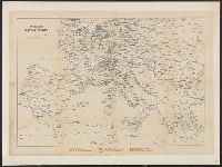
Published / Created:
[1890?]
Call Number:
304ag 1890
Container / Volume:
BRBL_00034A
Image Count:
1
Resource Type:
Maps, Atlases & Globes
Description:
Shows railroads and steamer routes.
Publisher:
Thos. Cook & Son,
Subject (Geographic):
Europe--Maps
Subject (Topic):
Railroads--Europe--Maps
Found in:
Beinecke Rare Book and Manuscript Library > Cook's map of central Europe.
Branch:v1.61.6 ,Deployed:2024-06-12T09:55:37-04:00