Skip to search
Skip to main content
Skip to first result
Search
You Searched For
Language
German
Publication Place
Wien :
New Search
Search Results
Published / Created:
[1885?]
Call Number:
428 IN7 1885
Container / Volume:
BRBL_00248
Image Count:
2
Resource Type:
Maps, Atlases & Globes
Alternative Title:
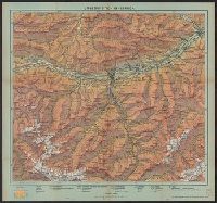
R. Maschek's Touristenkarte
Publisher:
A. Artaria et Comp.,
Subject (Geographic):
Tyrol (Austria)--Maps
Found in:
Beinecke Rare Book and Manuscript Library > Umgebung von Innsbruck, der Achen-See, das Ziller-thal und der Venediger Blatt VII / Rud. Maschek sen.
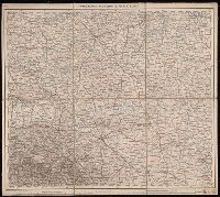
Published / Created:
[1915?]
Call Number:
428 In7 1915
Container / Volume:
BRBL_00248
Image Count:
1
Resource Type:
Maps, Atlases & Globes
Publisher:
Freytag & Berndt,
Subject (Geographic):
Tyrol (Austria)--Maps
Found in:
Beinecke Rare Book and Manuscript Library > Umgebung von Innsbruck.
Published / Created:
[1885]
Call Number:
428 IN7 1885A
Container / Volume:
BRBL_00248
Image Count:
2
Resource Type:
Maps, Atlases & Globes
Description:
In lower right corner: "41-85".
Publisher:
K.u.k. militärgeographisches Institut,
Subject (Geographic):
Tyrol (Austria)--Maps
Found in:
Beinecke Rare Book and Manuscript Library > Umgebungskarte von Innsbruck.
Published / Created:
1944
Call Number:
43 1944
Container / Volume:
BRBL_00250
Image Count:
1
Resource Type:
Maps, Atlases & Globes
Description:
"III.44.D80." and AMS captured map.
Publisher:
Publikationsstelle,
Subject (Geographic):
Hungary--Maps
Found in:
Beinecke Rare Book and Manuscript Library > Ungarn.
Creator:
Published / Created:
1882-1886.
Call Number:
304 1886
Container / Volume:
Series Box 1
Image Count:
4
Resource Type:
Maps, Atlases & Globes
Description:
Copy 3: Imperfect: all sheets but C2, C3, and D3 wanting., Covers Europe from western France to eastern Russia, and from the North Sea to the Aegean Sea., and Relief shown by hachures and spot heights.
Publisher:
K.K. Militär-geographisches Institute,
Subject (Geographic):
Europe, Central--Maps
Found in:
Beinecke Rare Book and Manuscript Library > Übersichts-Karte von Mittel-Europa, im Masse 1:750.000 der Natur / bearbeitet und herausgegeben vom K.K. Militär-geographischen Institute.
Creator:
Published / Created:
1882-1886.
Call Number:
304 1886
Container / Volume:
Series Box 1
Image Count:
49
Resource Type:
Maps, Atlases & Globes
Description:
Covers Europe from western France to eastern Russia, and from the North Sea to the Aegean Sea., Includes sheet index., Introductory sheets include title, location map, glossary, and legend., Pronunciation guide and abbreviations in 8 languages., Relief shown by hachures and spot heights., and Sheet title and scale bars affixed to verso. Only sheet F.6 verso digitized as reference.
Publisher:
K.K. Militär-geographisches Institute,
Subject (Geographic):
Europe, Central--Maps
Found in:
Beinecke Rare Book and Manuscript Library > Übersichts-Karte von Mittel-Europa, im Masse 1:750.000 der Natur / bearbeitet und herausgegeben vom K.K. Militär-geographischen Institute.
Creator:
Published / Created:
1882-1886.
Call Number:
304 1886
Container / Volume:
Series Box 1
Image Count:
6
Resource Type:
Maps, Atlases & Globes
Description:
Copy 2: Imperfect: all sheets but C1, C2, D1, D2, E1 and E2 wanting., Covers Europe from western France to eastern Russia, and from the North Sea to the Aegean Sea., and Relief shown by hachures and spot heights.
Publisher:
K.K. Militär-geographisches Institute,
Subject (Geographic):
Europe, Central--Maps
Found in:
Beinecke Rare Book and Manuscript Library > Übersichts-Karte von Mittel-Europa, im Masse 1:750.000 der Natur / bearbeitet und herausgegeben vom K.K. Militär-geographischen Institute.
Creator:
Published / Created:
1943
Call Number:
352fb St16 1936
Container / Volume:
BRBL_00110
Image Count:
1
Resource Type:
Maps, Atlases & Globes
Description:
"Ausgabe Dez. 1943." and Shows detailed administrative borders, railroads, roads and projected canals.
Publisher:
Publikationsstelle Wien,
Subject (Geographic):
Astrakhanskai︠a︡ oblastʹ (Russia)--Administrative and political divisions--Maps, Astrakhanskai︠a︡ oblastʹ (Russia)--Maps, Kalmykii︠a︡ (Russia)--Administrative and political divisions--Maps, and Kalmykii︠a︡ (Russia)--Maps
Found in:
Beinecke Rare Book and Manuscript Library > Verwaltungskarte des Gebietes Stalingrad und der Kalmücken ASSR [cartographic material] : Stand 1936 / bearbeitet und herausgegeben von der Publikationsstelle Wien.
Published / Created:
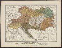
1858
Call Number:
41EF 1858
Container / Volume:
BRBL_00243
Image Count:
1
Resource Type:
Maps, Atlases & Globes
Description:
In lower margin: No. 8 bis (Atlas von Fr. Fried.) 1858.
Publisher:
Artaria & Co.,
Subject (Geographic):
Austria--Maps, Balkan Peninsula--Maps, and Hungary--Maps
Found in:
Beinecke Rare Book and Manuscript Library > Völker-Karte der Oesterreichischen Monarchie / Gest. v. D. Biller.
Published / Created:
1943
Call Number:
48ed 1943
Container / Volume:
BRBL_00264
Image Count:
1
Resource Type:
Maps, Atlases & Globes
Description:
"VII.1943 (D 80)".
Publisher:
Publikationsstelle Wien,
Subject (Geographic):
Greece--Maps
Found in:
Beinecke Rare Book and Manuscript Library > Weltkarte 1:1,000,000. Athen J 34.
Branch:v1.61.8 ,Deployed:2024-06-20T11:15:02-04:00