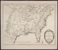
Bellin, Jacques Nicolas, 1703-1772, creator France, Depot des cartes et plans de la marine
Published / Created:
1755?
Call Number:
2003 Folio 85
Image Count:
1
Description:
Available also through the Library of Congress Web site as a raster image., BEIN 2003 Folio 85: No. 23 of 45 maps bound together with binder's spine title: Atlas of America; ms. table of contents. Bookplate: Robinson. Bookplate of Paul Mellon., Covers the area from Quebec to the Gulf of Mexico and west of Santa Fe, N.M., Hand colored., LC Maps of North America, 1750-1789,, Longitude du meridien de l'ile de Fer., Par le Sr. Bellin, ingr. ordre. de la marine, 1750., Relief shown pictorially., Scale [ca. 1:5,800,000]., Shows cities and towns, forts, some trails, and Indian villages and tribal territory., and Sur de nouvelles observations on a corrige les lacs, et leurs environs, 1755.
Subject (Geographic):
Louisiana -- Maps -- Early works to 1800 and North America -- Maps -- Early works to 1800
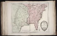
Bar scale given in "echelle de cent lieues Francoises"., Copy 3: Sh, Includes notes., Inset: Carte particuliere des embouchures de la riviere S. Louis et de la Mobile. Scale [ca. 1:2,700,000]., Relief shown pictorially., and Shows some explorers' routes.
Publisher:
Chez Jean Cóvens et Corneille Mortier, geographes,
Subject (Geographic):
Louisiana--Maps--Early works to 1800, Mississippi River Valley--Maps--Early works to 1800, and United States--Maps--Early works to 1800
Subject (Name):
Cóvens et Mortier. Atlas nouveau and Le Maire, François
Appears in the Cóvens et Mortier's Atlas nouveau, 1730 and later eds., Bar scale given in "echelle de cent lieues Francoises"., Copy 2: With watermark. Sheet measures 54.6 x 63.4 cm., and Inset: Carte particuliere des embouchures de la riviere S. Louis et de la
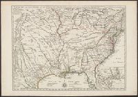
Publisher:
Chez Jean Cóvens et Corneille Mortier, geographes,
Subject (Geographic):
Louisiana--Maps--Early works to 1800, Mississippi River Valley--Maps--Early works to 1800, and United States--Maps--Early works to 1800
Subject (Name):
Cóvens et Mortier. Atlas nouveau and Le Maire, François
Appears in the Cóvens et Mortier's Atlas nouveau, 1730 and later eds., Bar scale given in "echelle de cent lieues Francoises"., Copy 1: Bookseller's label: Libreria Loescher e Co. ... Roma. Mounted on linen. Sheet measures 56.5 x 65.8 cm., and Covers eastern Un
Publisher:
Chez Jean Cóvens et Corneille Mortier, geographes,
Subject (Geographic):
Louisiana--Maps--Early works to 1800, Mississippi River Valley--Maps--Early works to 1800, and United States--Maps--Early works to 1800
Subject (Name):
Cóvens et Mortier. Atlas nouveau and Le Maire, François
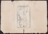
"A. Pl. 17.", From Nicolas-Gabriel Clerc's Histoire physique, morale, civile et politique de la Russie moderne., Relief shown by hachures., Stamp on verso: Douane francaises ... 31 avr 70., and Watermark.
Subject (Geographic):
Caspian Sea--Maps--Early works to 1800
Subject (Name):
Clerc, Nicolas-Gabriel, 1726-1798. Histoire physique, morale, civile et politique de la Russie moderne and Tardieu, P. F. (Pierre François), 1757-1822, engraver