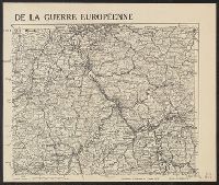
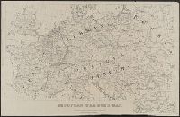
"G. Peltier, Paris" in bottom right corner of map., "Supplément à l'illustration du Janvier 1915.", and Shows railways, roads, canals, borders, and fortifications.
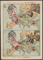
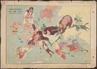
Año despues !!la realidad!! and Serio-comique map of Europe at war.
Description:
After Johnson, Riddle & Co.'s Serio-comique map of Europe at war., Caricature map., Countries are represented by drawings of people, animals, etc. to depict wartime attitudes., and Within neat line of Europa al principio de la guerra: Hark! Hark! The dogs do bar
Publisher:
s.n.,
Subject (Geographic):
Europe--Maps and Europe--Politics and government--Maps
Subject (Topic):
World War, 1914-1918--Caricatures and cartoons and World War, 1914-1918--Maps
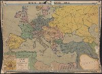
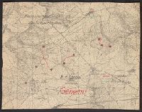
Accompanied by sheet containing overlay diagrams "Sperrfeuer Remenauville" and "Sperrfeuer: Mort-Mare-Wald". and Ms. annotations in German. Imperfect: cut around borders.
Publisher:
s.n.,
Subject (Geographic):
Champagne-Ardenne (France)--Maps and Lorraine (France)--Maps
Subject (Topic):
Electric lines, Telephone lines, World War, 1914-1918--France--Lorraine, and World War, 1914-1918--Maps
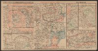
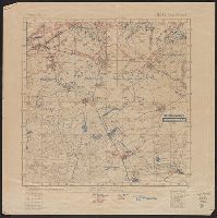
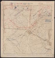
"Abgeschlossen am 18.7.18"., In upper right margin: Bl. 142, Bernécourt., Legend indicates trench information in red and blue ink., and Ms. annotations in German indicating trench information.
Publisher:
s.n.,
Subject (Geographic):
Lorraine (France)--Military maps
Subject (Topic):
World War, 1914-1918--France--Lorraine and World War, 1914-1918--Maps
Legend indicates trench information in red and blue ink., Northeast, northwest, and southwest corners of Bl. 142, Bernécourt., and Northeastern sheet: "Abgeschlossen am 10.6.18"; Northwestern sheet: "Abgeschlossen am 20.5.18"; Southwestern sheet: "Abgeschlosse am 20.5.18"; Southwestern sheet: "Abgeschlossen am 17.6.18".
Publisher:
s.n.,
Subject (Geographic):
Lorraine (France)--Military maps
Subject (Topic):
World War, 1914-1918--France--Lorraine and World War, 1914-1918--Maps