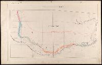
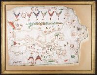
Contains eight compass roses., Decoration: armorial shields, city views with gilded banners, tents, and Madonna with child., In frame 92 x 118 cm., Pen-and-ink in brown, red, blue and green., Portolan chart with seaport names given for all coastlines., and Title devised by cataloger.
Subject (Geographic):
Baltic Sea--Maps--Early works to 1800., Mediterranean Sea--Maps--Early works to 1800., and North Atlantic Ocean--Maps--Early works to 1800.
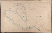
Subject (Topic):
Manuscript maps --Mediterranean Region, Portolanos --Europe, and Portolanos --Mediterranean Region
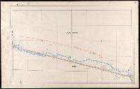
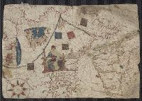
Contains five compass roses., Decoration: city views with banners, figures holding armorial shields, animals, and Jesus Christ on the cross flanked by the Virgin Mary and Mary Magdalene., Includes degrees of latitude along left edge: 18°N to 63°N., Includes two North Atlantic islands "Frislandia" and "Stilanda" in upper left corner and inset map of the world in the lower center., Pen-and-ink in black, red, blue and green., Portolan chart with seaport names given for all coastlines., and Title devised by cataloger; last two numerals of date have been altered.
Subject (Geographic):
Baltic Sea--Maps--Early works to 1800, Mediterranean Sea--Maps--Early works to 1800, and North Atlantic Ocean--Maps--Early works to 1800
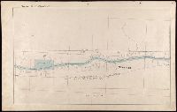
From Coronelli's Corso geografico universale., Globe gores for small celestial and terrestrial globes by Vincenzo Coronelli., The terrestrial globe gore map has "345" in upper right corner and is signed "Aut. il. P. Cosmografo Coronelli in Venetia 1693.", Title devised by cataloger., and Watermark.
Subject (Name):
Coronelli, Vincenzo, 1650-1718. Corso geografico universale.
Subject (Topic):
Celestial globes--Early works to 1800--Facsimiles. and Globes.