"27" in top right-hand corner., Map showing N.S.W. and Victoria divided into counties with notes on the topography. Gold deposits are marked. Relief shown by hachures and spot heights., and Stamp on verso: Karpinski-von Wieser Map Collection.
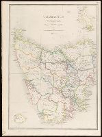
Inset: Kings Island., Map of Tasmania showing counties, railways and tramways with notes on the topography. Relief shown pictorially and by hachures and spot heights., Plate "28.", and Stamp on verso: Karpinski-von Wieser Map Collection.
Publisher:
James Wyld, Geographer to the Queen, 457, West Strand, Charing Cross East,