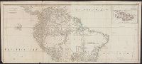
Also appeared in Kitchin's General atlas describing the whole universe. London : Printed for Robert Sayer, [1780]., Includes descriptive notes and text "Division of South America with a summary account of its trade," and large ornamental cartouche., Inset map: Chart of the Falkland's Islands : named by the French Malouine Islands, and discovered by Hawkins in the year 1595. Scale [ca. 1:2,000,000]., Prime meridian: Ferro., Relief shown pictorially; depths by soundings., Sheets measures 54 x 122.7 cm., and Sheets mounted together to form 2 sheets.
Publisher:
Printed for Robert Sayer,
Subject (Geographic):
Falkland Islands--Maps--Early works to 1800 and South America--Maps--Early works to 1800
Subject (Name):
Anville, Jean Baptiste Bourguignon d', 1697-1782, Kitchin, Thomas, d. 1784, and Kitchin, Thomas, d. 1784. General atlas describing the whole universe
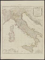
Carte de l'Italie et de touts ses routes de poste, à l'usage de voyageurs
Description:
Appears in Laurie and Whittle, A new universal atlas, 1796, plate 16., Horizontal fold at middle of map and guard on verso., Includ, Relief shown pictorially., and Sheet measures 72 x 54 cm. Stamp on verso: Karpinski-von Wieser Map Collection. dgvmp2008.
Publisher:
Laurie & Whittle,
Subject (Geographic):
Italy--Maps--Early works to 1800
Subject (Name):
Anville, Jean Baptiste Bourguignon d', 1697-1782 and Robert Laurie and James Whittle
Also shows anchorages, currents, and routes of navigation along the coast., Includes historical notes, text, 10 insets of harbors, and a table showing that "North America is divided into the continent & the islands" according to geography and politics., and Rel
Publisher:
Printed for Robt. Sayer,
Subject (Geographic):
North America--Maps--Early works to 1800
Subject (Name):
Anville, Jean Baptiste Bourguignon d', 1697-1782 and Robert de Vaugondy, Didier, 1723-1786
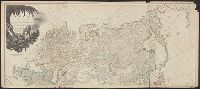
Also appeared in Kitchin's General atlas describing the whole universe. London : Printed for Robert Sayer, [1780]., Relief shown pictorially., Sheets m, Sheets mounted together to form 2 sheets., and Title cartouche depicts local produce, a palm tree and a camel.
Publisher:
Printed for Robert Sayer,
Subject (Geographic):
Asia--Maps--Early works to 1800
Subject (Name):
Abbot, Charles,--Baron Colchester,--1757-1829--Bookplate, Anville, Jean Baptiste Bourguignon d', 1697-1782, Cook, James, 1728-1779, Kitchin, Thomas, d. 1784. General atlas describing th, and Sayer, Robert, 1725-1794
"This map is copied from an original drawn by Monsr. D'Anville ... & published at Paris in 1751. But since the Peace of 1762, that map has been supressed [sic] ... ", Includes descriptive notes,, Prime meridians: Ferro and London., and Relief shown pictorially.
Publisher:
Printed for Robert Sayer in Fleet Street & Thomas Jefferys in the Strand,
Subject (Geographic):
Africa, West--Maps--Early works to 1800, Coasts--Africa, West--Maps--Early works to 1800, and Gambia--Colonization--Maps--Early works to 1800
Subject (Name):
Anville, Jean Baptiste Bourguignon d', 1697-1782 and Sayer, Robert, 1725-1794
"This map is copied from an original drawn by Monsr. D'Anv, Also appeared in Kitchin's General atlas describing the whole universe. London : Printed for Robert Sayer, [1780]., Prime meridians: Ferro and London., and Relief shown pictorially; depths by soundings.
Publisher:
Printed for Robert Sayer,
Subject (Geographic):
Africa, West--Maps--Early works to 1800
Subject (Name):
Abbot, Charles,--Baron Colchester,--1757-1829--Bookplate, Anville, Jean Baptiste Bourguignon d', 1697-1782, Kitchin, Thomas, d. 1784. General atlas describing the whole universe, and Robert Laurie and James Whittle