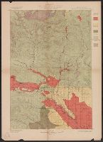
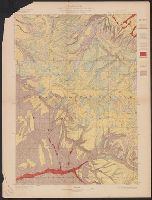
"Julius Bien & Co. Lith. N.Y.", "Surveyed in 1896-97.", Plate CXXXI from the "Twenty-first annual report" of the U.S. Geological Survey, Part 5, Forests reserves (1900)., Relief shown by contours and spot heights., and Shows five classes of land cover.
Publisher:
The Survey,
Subject (Geographic):
Chelan County (Wash.)--Maps, Kittitas County (Wash.)--Maps, and Wenatchee National Forest (Wash.)--Maps
Subject (Name):
Geological Survey (U.S.). Annual report and Plummer, Fred G. (Fred Gordon), 1864-1913
Subject (Topic):
Forests and forestry--Washington (State)--Chelan County--Maps, Forests and forestry--Washington (State)--Kittitas County--Maps, and Land capability for agriculture--Washington (State)--Kittitas County--Maps
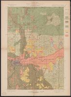
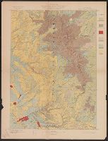
"Engraved April 1901 by Julius Bien & Co., "Surveyed in 1898.", Plate CXXXIV from the "Twenty-first annual report" of the U.S. Geological Survey, Part 5, Forest reserves (1900)., Relief shown by contours and spot heights., and Shows six classes of land cover.
Publisher:
The Survey,
Subject (Geographic):
Spokane County (Wash.)--Maps
Subject (Name):
Geological Survey (U.S.). Annual report, Manning, Van H, and Plummer, Fred G. (Fred Gordon), 1864-1913
Subject (Topic):
Forests and forestry--Washington (State)--Spokane County--Maps and Land capability for agriculture--Washington (State)--Spokane County--Maps
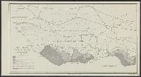
[Maury map collection ; ser. A2], Maury's wind & current chart, S. Atlantic, Maury's wind & current chart, South Atlantic, Maury's wind and current chart, series A, South Atlantic, Maury's wind and current chart, South Atlantic, and South Atlantic
Description:
"Series A.", Copy imperfect: All sheets torn and repaired along, Does not cover the southeastern Atlantic south of latitude 40° S., Includes notes., Shows prevailing wind direction by month., and Various eds. of some sheets with updated and additional information.
Publisher:
United States Hydrographical Office,
Subject (Geographic):
South Atlantic Ocean--Charts, diagrams, etc
Subject (Name):
Flye, Wm, Maury, Matthew Fontaine, 1806-1873. Wind and current charts, Sherman & Smith, Temple, William G. (William Grenville), 1824-1894, United States Naval Observatory, United States. Bureau of Ordnance and Hydrography, and United States. Hydrographic Office
[Maury map collection ; ser. A2], Maury's wind & current chart, S. Atlantic, Maury's wind & current chart, South Atlantic, Maury's wind and current chart, series A, South Atlantic, Maury's wind and current chart, South Atlantic, and South Atlantic
Description:
"Series A.", DLC, Includes notes., Sheet 1 (1853) -- Sheet 2 (no date) -- Sheet 3 (no date) -- Sheet 3 (Updated) -- Sheet 4 (no date), 2 copies., Sheets individually numbered, e.g.: Series A. No. 1., and Various eds. of some sheets with updated and additional info
Publisher:
United States Hydrographical Office,
Subject (Geographic):
South Atlantic Ocean--Charts, diagrams, etc
Subject (Name):
Flye, Wm, Maury, Matthew Fontaine, 1806-1873. Wind and current charts, Sherman & Smith, Temple, William G. (William Grenville), 1824-1894, United States Naval Observatory, United States. Bureau of Ordnance and Hydrography, and United States. Hydrographic Office
[Maury map collection ; ser. A2], Maury's wind & current chart, S. Atlantic, Maury's wind & current chart, South Atlantic, Maury's wind and current chart, series A, South Atlantic, Maury's wind and current chart, South Atlantic, and South Atlantic
Description:
"Series A.", Copy imperfect: All sheets torn and repaired along fold-line. Sheet 3 liquid staining, minor losses along edges and discoloration throughout, mounted on cloth backing., Does not cover the southeastern Atlantic south of latitude 40° S., and Originall
Publisher:
United States Hydrographical Office,
Subject (Geographic):
South Atlantic Ocean--Charts, diagrams, etc
Subject (Name):
Flye, Wm, Maury, Matthew Fontaine, 1806-1873. Wind and current charts, Sherman & Smith, Temple, William G. (William Grenville), 1824-1894, United States Naval Observatory, United States. Bureau of Ordnance and Hydrography, and United States. Hydrographic Office
"Julius Bien & Co. Lith. N.Y.", "Surveyed in 1898.", Plate CXXXIX from the "Twenty-first annual report" of the U.S. Geological Survey, Part 5, Forest reserves (1900)., Relief shown by contours and spot heights., and Shows six classes of land cover.
Publisher:
The Survey,
Subject (Geographic):
Big Horn County (Wyo.)--Maps, Bighorn National Forest (Wyo.)--Maps, and Sheridan County (Wyo.)--Maps
Subject (Name):
Geological Survey (U.S.). Annual report and Tweedy, Frank, 1854-1937
Subject (Topic):
Forests and forestry--Wyoming--Big Horn County--Maps, Forests and forestry--Wyoming--Sheridan County--Maps, Land capability for agriculture--Wyoming--Big Horn County--Maps, and Land capability for agriculture--Wyoming--Sherida
"Julius Bien & Co. Lith. N.Y.", "Surveyed in 1897-99.", Plate CXL from the "Twenty-first annual report" of the U.S. Geological Survey, Part 5, Forest reserves (1900)., Relief shown by contours and spot heights., and Shows six classes of land cover.
Publisher:
The Survey,
Subject (Geographic):
Big Horn County (Wyo.)--Maps, Bighorn National Forest (Wyo.)--Maps, and Johnson County (Wyo.)--Maps
Subject (Name):
Geological Survey (U.S.). Annual report and Matthes, François, 1874-1948
Subject (Topic):
Forests and forestry--Wyoming--Big Horn County--Maps, Forests and forestry--Wyoming--Johnson County--Maps, Land capability for agriculture--Wyoming--Big Horn County--Maps, and Land capability for agriculture--Wyoming--Johnson
"Julius Bien & Co. Lith. N.Y.", "Surveyed in 1899.", Plate CXXXVIII from the "Twenty-first annual report" of the U.S. Geological Survey, Part 5, Forest reserves (1900)., Relief shown by contours and spot heights., and Shows six classes of land cover.
Publisher:
The Survey,
Subject (Geographic):
Bighorn National Forest (Wyo.)--Maps and Sheridan County (Wyo.)--Maps
Subject (Name):
Geological Survey (U.S.). Annual report, Julius Bien & Co, and Tweedy, Frank, 1854-1937
Subject (Topic):
Forests and forestry--Wyoming--Sheridan County--Maps and Land capability for agriculture--Wyoming--Sheridan County--Maps