Skip to search
Skip to main content
Skip to first result
Search
You Searched For
Extent of Digitization
Partially digitized
Genre
Maps
New Search
Search Results
Published / Created:
1802
Call Number:
Im B388 Zz802B
Collection Title:
The imperial guide : with picturesque plans of the great post roads, containing miniatures
Image Count:
1
Description:
Bound in between p. 6-7. and William Beckford’s copy, with his penciled annotations. Autograph of William Beckford.
Subject (Geographic):
England --Guidebooks, England --Maps, Great Britain --Description and travel --Views, and Great Britain --Road maps
Subject (Topic):
Roads --Great Britain
Collection Created:
London : Printed by C. Whittingham, Dean Street, Fetter Lane, and sold by H.D. Symonds, Paternoster-Row; [etc], 1802
Found in:
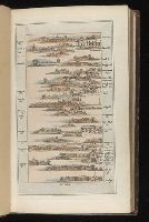
Beinecke Rare Book and Manuscript Library > [Map: Stafford to Coventry]
Published / Created:
1802
Call Number:
Im B388 Zz802B
Collection Title:
The imperial guide : with picturesque plans of the great post roads, containing miniatures
Image Count:
1
Description:
Bound in between p. 10-11. and William Beckford’s copy, with his penciled annotations. Autograph of William Beckford.
Subject (Geographic):
England --Guidebooks, England --Maps, Great Britain --Description and travel --Views, and Great Britain --Road maps
Subject (Topic):
Roads --Great Britain
Collection Created:
London : Printed by C. Whittingham, Dean Street, Fetter Lane, and sold by H.D. Symonds, Paternoster-Row; [etc], 1802
Found in:
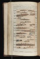
Beinecke Rare Book and Manuscript Library > [Map: Talk on the Hill to Birmingham]
Call Number:
Za St78 855f
Collection Title:
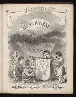
First geography for children / by Mrs. Harriet Beecher Stowe
Image Count:
9
Resource Type:
Books, Journals & Pamphlets
Subject (Geographic):
Africa
Subject (Topic):
Geography --Textbooks, Slavery, and Slaves --Social conditions
Collection Created:
Boston : Phillips, Sampson, and Co. ; New York : J.C. Derby, 1855
Found in:
Beinecke Rare Book and Manuscript Library > [Selected pages]
Call Number:
MMLm143 778bc
Collection Title:
The self-interpreting Bible: containing the sacred text of the Old and New Testaments. Translated
Image Count:
5
Description:
Binder’s title: Brown’s Bible. and Includes bound in map of the Holy Land (folded) 42 x 24 cm.
Subject (Topic):
Bible. O.T. and Palestine--Maps--Early works to 1800
Collection Created:
New-York : Printed by Hodge and Campbell, and sold at their respective book stores, M.DCC.XCII
Found in:
Beinecke Rare Book and Manuscript Library > [Selected pages]
Creator:
Published / Created:
[1850]
Call Number:
WA MSS 206
Collection Title:
Overland journey across the Plains to Oregon /by William H. Frush, 1850-1852
Image Count:
4
Abstract:
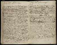
In 1850 Frush traveled from Missouri to Oregon by way of St. Joseph, Blue River, the North Platte, and Fort Laramie, where he met his brother John and Kit Carson. They continued by South Pass, Bear River, Soda Springs, Fort Hall, Fort Boise, the Dalles, and Portland. He records graves, the names and homes of other travelers, and ends his account with events in Oregon. The diary contains drawings of Chimney Rock, Court House Rock, profile of the Snake River, and a map of the Burnt River.
Subject (Geographic):
Oregon --Baker County --Maps, West (U.S.) --Description and travel, and West (U.S.) --Maps
Found in:
Beinecke Rare Book and Manuscript Library > [Selected pages]
Call Number:
1983 Folio 44
Collection Title:
Isolario : descrittione geografico-historica, sacro-profana, antico-moderna, politica, naturale, e
Image Count:
3
Resource Type:
Books, Journals & Pamphlets
Subject (Geographic):
Lazzaretto Nuovo Island (Italy) and Murano (Italy)--Maps, Pictorial--Early works to 1800
Subject (Topic):
Geography --Early works to 1800 and Islands--Italy
Collection Created:
In Venetia : A’ spese dell’autore, 1696 [i.e. 1697]
Found in:
Beinecke Rare Book and Manuscript Library > [Selected pages]
Published / Created:
[1808]
Call Number:
In W890 Zz808
Collection Title:
The history of the rise, progress, and accomplishment of the abolition of the African slave-trade
Image Count:
1
Resource Type:
Maps, Atlases & Globes
Description:
Autographed presentation copy to Mrs. Elizabeth Cookson from S.T. Coleridge; on fly-leaf at front of v.1 is Mrs. Wordsworths manuscript copy of her husbands sonnet, "To Thos. Clarkson, on the final passing of the bill for the abol and Folded map facing p. 259
Subject (Topic):
Slave trade. and Slavery
Collection Created:
London : Longman, Hurst, Rees, and Orme, 1808
Found in:
Beinecke Rare Book and Manuscript Library > [Untitled map of abolition of the slave trade]
Creator:
Published / Created:
[1739?]
Call Number:
1973 folio 44
Collection Title:
Plan de Paris commence l’annee 1734. Dessine et gravesous les ordres de Messire Michel Etienne
Image Count:
1
Resource Type:
Maps, Atlases & Globes
Description:
Consists of 20 numbered sectional plans of Paris. and Scale about 1:1800.
Subject (Geographic):
Paris (France) --Maps
Subject (Topic):
Architecture --France --Paris
Collection Created:
[Paris? 1739?]
Found in:
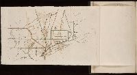
Beinecke Rare Book and Manuscript Library > [Untitled sectional plan of Paris]
Branch:v1.61.6 ,Deployed:2024-06-12T09:55:31-04:00