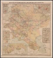
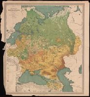
Ilʹin, A. A. (Alekseĭ Alekseevich), 1858-1942 Ильинъ, А. А. (Алексей Алексеевич), 1858-1942.
Published / Created:
[1885?]
Call Number:
BrSides Folio 2019 106
Image Count:
2
Resource Type:
Maps, Atlases & Globes
Alternative Title:
Karta vashneshchikhʺ otrasleĭ promyshlennosti Evropeĭskoĭ Rossiĭ, Klimaticheskai︠a︡ karta Evropeĭskoĭ Rossiĭ, Klimaticheskai︠a︡ karta Evropeĭskoĭ Rossīi, Карта вашнещихъ отраслей промышленности Европейской Россий, Карта вашнѣщихъ отраслей промышленности Европейской Россіи ; Климатическая карта Европейской Россіи., Климатическая карта Европейской Россий, and Климатическая карта Европейской Россіи
Description:
From A.A. Ilʹin's Uchebnyĭ geograficheskiĭ atlas (1885)., From A.A. Ilʹin's Учебный географический атласъ (1885)., Imperfect: chipped., Prime meridians: Greenwich and Pulkovo., and Relief shown by hachures.
Publisher:
Kartograficheskoe zavedenīi︠a︡ A. Ilʹina,
Subject (Geographic):
Russia--Climate--Maps.
Subject (Name):
Ilʹin, A. A. (Alekseĭ Alekseevich), 1858-1942. Uchebnyĭ geograficheskiĭ atlas., Kartograficheskoe zavedenīe A. Ilʹina, Ильинъ, А. А. (Алексей Алексеевич), 1858-1942. Учебный географический атласъ., and Картографическаго заведения А. Ильина, publisher.
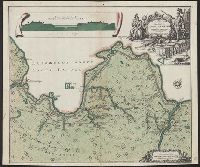
"Cum priv. Sum̄i Vicariat in part. Rheni, Franc., et Suev. juris.", Includes canal profile and ornamental cartouche., Oriented with north toward the upper right., Relief shown by hachures., and Russian and Latin.
Publisher:
M. Seutter,
Subject (Geographic):
Ladoga Lake Region (Russia)--Maps--Early works to 1800
Subject (Topic):
Canals--Russia--Ladoga Lake Region--Maps--Early works to 1800
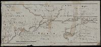
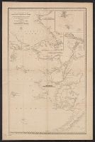
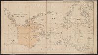
Russia. Gidrograficheskīĭ departament, creator Russia. Гидрографическій департамент
Published / Created:
1858 Ii︠u︡ni︠a︡.
Call Number:
848cea B45 1858
Container / Volume:
BRBL_00635
Image Count:
1
Resource Type:
Maps, Atlases & Globes
Alternative Title:
Меркаторская карта Ледовитаго и Берингова морей с сѣверозападнымъ Беренгом Америки : отъ мыса Лисбурна до полуострова Аляски / составлена из разныхъ журналовъ и картъ и гравирована въ Гидрографическомъ департаментѣ Морскаго министерства, 1852.
Description:
"1455" in lower right corner., "No. 6, Vostochnago Okeana" above neat line., Insets: I︠A︡kornoe mi︠e︡sto i osva. Shamisso -- Port K, Mounted on linen., Publishing date in lower left corner., and Relief shown by hachures and spot heights. Depths shown by soundings.
Publisher:
[Morskoe ministerstvo],
Subject (Geographic):
Alaska--Maps, Bering Sea--Maps, Chukchi Peninsula (Russia)--Maps, and Chukchi Sea--Maps