Cartouche lacks privilege., Includes text and ornamental cartouche with Africans, Europeans, flora, fauna, etc., Relief shown pictorially., and Sheet measures 52 x 60 cm. Ms. no. on recto: 58 [?].
"Cum privil. S.C.M. nec non S.R.M. Polon. et Elect. Sax. A. 1737.", Includes text and ornamental cartouche with Africans, Europeans, flora, fauna, etc., Relief shown pictorially., and Sheet measures 52 x 62 cm.
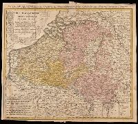
Belgium Catholicum seu decem provinciae Germaniae inferioris and Carte des Pais Bas catholiques où des X provinces de l'Allegmagne inférieure, etc. dessinée au juste selon les exactes observations astronomiques et opérations géometriques des Messur. Cass
Description:
"Avec privil. Imperial" above neat line., Includes 8 bar scales., Includes coats-of-arms of ten provinces., Relief shown pictorially., and Watermark. Manuscript number in upper right corner: 262[?]. From the Karpinski-von Wieser Map Collection.
Publisher:
Edentibus Homannianis heredib.,
Subject (Geographic):
Belgium--Maps--Early works to 1800. and Luxembourg--Maps--Early works to 1800.
Subject (Name):
Cassini, César-François, 1714-1784, Homann Erben (Firm), and Snellius, Willebrord, 1580-1626
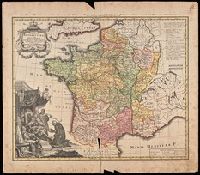
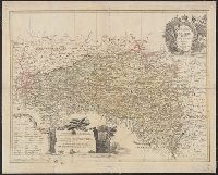
France Benedictine, ou carte generale des abbayes, & prieurez conventuels de l'Ordre de S. Benoit, tant d'hommes, que de filles, au jour a Norimberg, a 1738
Description:
Bottom left shows St. Maurice offering a book of prayers to Theodebert I, King of France who answers: "Plura Maurus precibus quam Nos Armis.", Imperfect: torn along bottom fold, with no loss of text. Watermark. Manuscript number in right corner: 19. From the Karpinski-von Wieser Map Collection., Includes note and legend., and Relief shown pictorially.
Publisher:
Recude[n]tibus Homan[n]ian. Heredib
Subject (Geographic):
France--Maps--Early works to 1800.
Subject (Name):
Homann Erben (Firm)
Subject (Topic):
Benedictine monasteries--France--Maps--Early works to 1800., Benedictine nuns--France--Maps--Early works to 1800., Convents, and Convents--France--Maps--Early works to 1800.
[Atlas factice of 42 maps, produced by the Homann Erben firm]
Image Count:
1
Resource Type:
Maps, Atlases & Globes
Alternative Title:
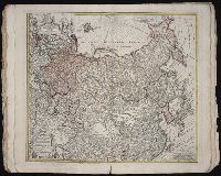
Imperii Russici et Tatariae universae tam majoris et Asiaticae, quam minoris et Europaeae tabula
Description:
"Cum privil. S.C.M. nec non R.M. Pol. et E. Sax.", Bar scale about 38 German miles to a centimeter., Decorated title cartouche depicts two hunters with rifles, a bear, and dog., Imperfect: edges frayed, torn along fold, with no loss of text. No. 33 of 42 maps bound together., In lower left margin: Notati etiam in hac mappa extant limites inter Russiam et Tatariam minorem post pacem recentissime a[nn]o 1739 initam., Includes dedicatory cartouche to Anna, Empress of Russia in upper left corner., Prime meridian: Paris., Relief shown pictorially., and Sea of Korea referred to as "Mare Orientale Minus."
Publisher:
Impensis Homannianorum Heredum
Subject (Geographic):
China--Maps--Early works to 1800., India--Maps--Early works to 1800., Japan--Maps--Early works to 1800., Korea--Maps--Early works to 1800., Russia--Maps--Early works to 1800., and Tibet (China)--Maps--Early works to 1800.
Subject (Name):
Anna,--Empress of Russia,--1693-1740., Homann Erben (Firm), and Schneider, R. A., engraver.
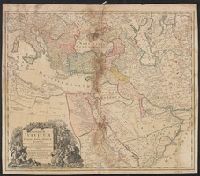
Tabula ex novissimus ad mentem de L'Islii, inprimis vero celeberrimi geographi Dni. I.M. Hasii, Prof. Vitemb. delineata a. 1737
Description:
"Cum privil. S.C.M. Grat.", Bar scales given in "milliaria Germanica," "milliaria Turcica," and "mill. Italica.", Relief shown pictorially., and Variant: without privilege statement in cartouche. Sheet measures 52.5 x 60.4 cm.
Publisher:
[Homann Erben,
Subject (Geographic):
Balkan Peninsula--Maps--Early works to 1800, Egypt--Maps--Early works to 1800, Libya--Maps--Early works to 1800, and Middle East--Maps--Early works to 1800
Subject (Name):
Hase, Johann Matthias, 1684-1742 and Homann Erben (Firm)
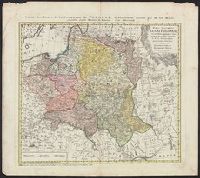
"Cum priv. Sac. Caes. Majestatis.", Backed with linen. Sheet measures 50.8 x 63.1 cm., Bar scales given in "geographische Meilen," "Roth Reussi[sche] und Pocuti[sche] Meilen," and "Hungarische Meilen.", Prime meridian: Paris., Relief shown pictorially., and Title
Publisher:
Impensis Homannianorum Haeredum,
Subject (Geographic):
Bohemia (Czech Republic)--Maps--Early works to 1800, Galicia (Poland and Ukraine)--Maps--Early works to 1800, and Ukraine--Maps--Early works to 1800
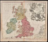
"Cum privilegio S.C.M.", Appeared in Homann's Atlas Novus Terrarum., Prime meridian: Ferro., Relief shown pictorially., Variant with portrait of George I in armour in the cartouche, Plymouth, England spelled correctly, and Delft, Netherlands misspelled "Dolft.", and Watermark. Manuscript number in upper right corner. From the Karpinski-von Wieser Map Collection.
Publisher:
[Johann Baptist Homann]
Subject (Geographic):
British Isles--Maps--Early works to 1800. and Europe--British Isles
Subject (Name):
Homann Erben (Firm) and Homann, Johann Baptist, 1663-1724. Atlas novus terrarum