Skip to search
Skip to main content
Skip to first result
Search
You Searched For
Genre
Maps
New Search
Search Results
Creator:
Published / Created:
[1943]
Call Number:
847gmb Se18 1943
Container / Volume:
BRBL_00629
Image Count:
2
Resource Type:
Maps, Atlases & Globes
Alternative Title:
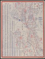
Map and guide to Seattle
Description:
Community info., photo, transit map, and "Map of downtown Seattle, showing hotels, public buildings, clubs, passenger terminals" on verso., Date inferred from "11-19-43" on verso transit map., and Includes inset of street designation system and indexes.
Publisher:
Kroll Map Co.,
Subject (Geographic):
Seattle (Wash.)--Maps
Subject (Name):
Seattle Chamber of Commerce
Subject (Topic):
Streets--Washington (State)--Seattle--Maps
Found in:
Beinecke Rare Book and Manuscript Library > Map of Seattle / courtesy of Seattle Chamber of Commerce.
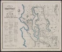
Creator:
Published / Created:
1884
Call Number:
847 Se18 1884
Container / Volume:
BRBL_00626
Image Count:
1
Resource Type:
Maps, Atlases & Globes
Description:
In lower right: Girsch & Co., 58 Ann St., N.Y., Indexed., Library's copy stamped: Oscar F. Long, U.S. Army, June 10, 1885., Relief shown by hachures., and Shows townships, additions, and drainage.
Publisher:
Eshelman Llewellyn & Co.?],
Subject (Geographic):
Seattle Region (Wash.)--Maps
Subject (Name):
Eshelman, Llewellyn & Co and Girsch & Co
Found in:
Beinecke Rare Book and Manuscript Library > Map of Seattle and vicinity / Eshelman Llewellyn & Co., real estate & money brokers ; office of F.C. Tucker, civil engineer and surveyor.
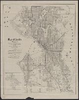
Published / Created:
c1911.
Call Number:
847 Se18 1912
Container / Volume:
BRBL_00627
Image Count:
2
Resource Type:
Maps, Atlases & Globes
Description:
"Copyright 1911 by Edgar Royer. Copyright 1908 by Arthur Von Babo.", Includes inset of "Rainier Beach.", and Map key and text on verso.
Publisher:
Seattle Pioneer Pocket Guide,
Subject (Geographic):
Seattle (Wash.)--Maps
Subject (Name):
Missigman, L and Seattle Pioneer Pocket Guide
Subject (Topic):
Streets--Washington (State)--Seattle--Maps
Found in:
Beinecke Rare Book and Manuscript Library > Map of Seattle, 1911-12 / drawn originally from official records in Office of City Engineer and revised by L. Missigman.
Creator:
Published / Created:
1870?]
Call Number:
582 1870A
Container / Volume:
BRBL_00314
Image Count:
1
Resource Type:
Maps, Atlases & Globes
Description:
Relief shown by hachures.
Publisher:
s.n.,
Subject (Geographic):
Cambodia--Maps and Thailand--Maps
Subject (Name):
American Mission Press (Singapore)
Found in:
Beinecke Rare Book and Manuscript Library > Map of Siam and some of its tributary provinces / constructed from various late surveys, travels and observations by S.G. McFarland.
Creator:
Published / Created:
1889
Call Number:
823 Si73 1889
Container / Volume:
BRBL_00568
Image Count:
1
Resource Type:
Maps, Atlases & Globes
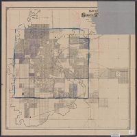
Description:
Cadastral map., Copy 2 annotated in purple pencil and missing portion of title block., and Shows public buildings and facilities.
Publisher:
H.M. Avery,
Subject (Geographic):
Sioux Falls (S.D.)--Maps
Subject (Topic):
Real property--South Dakota--Sioux Falls--Maps
Found in:
Beinecke Rare Book and Manuscript Library > Map of Sioux Falls, South Dakota / Jackson & Vance, civil engineers ; H.B. Stranahan & Co., engravers.
Creator:
Published / Created:
[1853]
Call Number:
26 1852
Container / Volume:
BRBL_00022
Image Count:
1
Resource Type:
Maps, Atlases & Globes
Description:
Dating: 1853 -Wyld's new address; before 1854, as Victorian railways not shown., Hand col. Mounted on linen. Sheet measures 68 x 101 cm., and Map of southern Australia with notes on the topography and gold deposits marked. Relief shown by hachures and
Publisher:
Published by Jas. Wyld, Geographer to the Queen, Charing Cross East ... & Model of the Earth, Leicester Square,
Subject (Geographic):
New South Wales--Maps, South Australia--Maps, Tasmania--Maps, and Western Australia--Maps
Found in:
Beinecke Rare Book and Manuscript Library > Map of South Australia, New South Wales, Van Diemens Land, and settled parts of Australia [cartographic material] / respectfully dedicated to Major Sir T.L. Mitchell Kt. D.C.L. F.G.S. &c Surveyor General of New South Wales by ... James Wyld.
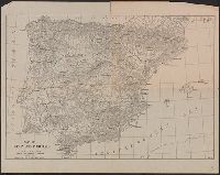
Creator:
Published / Created:
[1918]
Call Number:
39 1918
Container / Volume:
BRBL_00188
Image Count:
1
Resource Type:
Maps, Atlases & Globes
Alternative Title:
University of California map series ; no. 7 and University of California map series ; no. 7.
Description:
"To accompany A History of Spain, by Charles E. Chapman." and Relief shown by hachures.
Publisher:
University of California Press,
Subject (Geographic):
Portugal--Maps and Spain--Maps
Subject (Name):
University of California Press
Found in:
Beinecke Rare Book and Manuscript Library > Map of Spain and Portugal [cartographic material] / compiled by Charles E. Chapman.
Creator:
Call Number:
834gfc Sp22 1873
Container / Volume:
BRBL_00590
Image Count:
2
Resource Type:
Maps, Atlases & Globes
Description:
Includes ill. of "Garden City Gold Mining Co. works," "Alden Tunnel Co. works," "Lombard Gold Mining Co. works," and text. and Relief shown by shading.
Publisher:
Chicago Lithographing Co., 1873?]
Subject (Name):
Chicago Lithographing Co and Spanish Bar District (Colo.)--Maps
Subject (Topic):
Mines and mineral resources--Colorado--Clear Creek County--Maps
Found in:
Beinecke Rare Book and Manuscript Library > Map of Spanish Bar District, Clear Creek Co., Colorado Territory : showing location of tunnel & mining claims, mill sites & water powers / surveyed & platted by F.F. Brunè, co. surveyor, Clear Creek Co., Colorado.
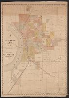
Creator:
Published / Created:
1883?]
Call Number:
847 Sp65 1883
Container / Volume:
BRBL_00627
Image Count:
1
Resource Type:
Maps, Atlases & Globes
Description:
"Entered according to act of Congress in th year 1883 A.D. by W.H. Maxwell in the office of the Librarian of Congress at Washington.", Library's copy missing bottom right corner., Relief shown by hachures., and Shows numbered lots, additions, Northern Pacific Railroad, and landowners.
Publisher:
W.T. Maxwell?,
Subject (Geographic):
Spokane (Wash.)--Maps
Subject (Topic):
Real property--Washington (State)--Spokane--Maps
Found in:
Beinecke Rare Book and Manuscript Library > Map of Spokane Falls, W.T. / compiled by W.H. Maxwell.
Creator:
Published / Created:
[1888]
Call Number:
816 Sa23 1888
Container / Volume:
BRBL_00562
Image Count:
1
Resource Type:
Maps, Atlases & Globes
Description:
"Supplement to Daily Herald, New-Year edition, 1888." and Shows numbered lots, additions, and railroads.
Publisher:
Rand McNally & Co.,
Subject (Geographic):
Saint Joseph (Mo.)--Maps
Subject (Name):
Rand McNally and Company
Subject (Topic):
Real property--Missouri--Saint Joseph--Maps
Found in:
Beinecke Rare Book and Manuscript Library > Map of St. Joseph, Mo. and vicinity / by T.M. Long, c.e.
Branch:v1.61.6 ,Deployed:2024-06-12T09:55:36-04:00