Bar scales given in English miles, 60 in a degree, Irish miles, 50 in a degree, and Dutch miles, 15 in a degree., Drawn from the survey made by Sr. Wm. Petty ; divided into its provinces, counties, and barronies, shewing also its bishopricks, borroughs, highwaies ... ; improved with many additions not extent in any other map., Includes inset map The sea coast of England, Scotland, and Ireland, Holland & part of France., No. 8 of 69 maps bound together in composite atlas., and Scale [ca. 1:540 000].
Publisher:
Sold by Rob. Morden at the Atlas in Corn-hil and by Christ. Brown at the Globe and Compasses in St. Pauls Churchyard
Appears in William Faden's Atlas of battles of the American Revolution. [1845], Indexed for points of interest., Library copy annotated "12" in black ink at lower right., Oriented with north to the left., and Relief shown by hachures.
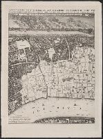
Engraved by George Vertue probably from Leake's orginial sheets., Library has sheet one only of two-sheet map., and Ms. note on map: This is apparently 1/5 [1/2?] of the so-called Faithorne map, published by Newcourt after Fire of 1666 and purporting to show Lo
Exact surveigh of the streets, lanes, and chvrches contained within the rvines of the city of London.
Description:
"Ionas Moore & Ralph Graterix, surveyors.", "The right honourable S. William Turner, the Lord Major, ao. 1669.", Alternate title: Plan of London after the fire., Bird's-eye-view., and Includes "The prospect of this citty, as it appeared from the opposite Southwar
Publisher:
London Topographical Society, and Nathanaell Brooke, stationer
Subject (Geographic):
London (England)--Aerial views--Early works to 1800--Facsimiles
Subject (Name):
Hollar, Wenceslaus, 1607-1677 and London Topographical Society
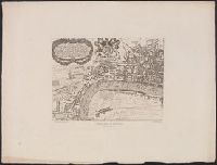
"From the 'Speculum Britanniæ' of John Norden, London 1593, 4to.", "Walker & Boutall, ph. sc.", Accompanied by title sheet with te, Bird's-eye-views., Has watermark., London map includes index and 14 coats of arms., London.--Westminster., and Title from title sheet.
Publisher:
London Topographical Society,
Subject (Geographic):
London (England)--Aerial views--Early works to 1800--Facsimiles and Westminster (London, England)--Aerial views--Early works to 1800--Facsimiles
Subject (Name):
Keere, Pieter van den, 1571-ca. 1646 and London Topographical Society
"Reproduced from the practically unique example in the library of the Society of Antiquaries.", "Walker & Boutall, ph. sc.", Alternate title: Map of London and Westminster., Bird's-eye-view., Cover tit, Includes text, index, and 2 coats of arms., and Text on cover.
Publisher:
London Topographical Society, and Printed & sould by Robt. Walton
Subject (Geographic):
London (England)--Aerial views--Early works to 1800--Facsimiles and Westminster (London, England)--Aerial views--Early works to 1800--Facsimiles
Subject (Name):
London Topographical Society and Walton, Robert, 1618-1688
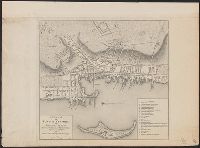
Principal islands in America belonging to the English empire viz Jamaica, Barbados, Antegoa, St. Christophers & Bermudos
Description:
[Antigua and Bermuda Islands] -- A general map of the Cariby Islands -- [Saint Kitts] -- [Barbados] -- The explanation of the marks on the island of Iamaica., Bar scale given in miles., No. 62 of 69 maps bound together in composite atlas., Relief shown pictorially., and Scales differ.
Publisher:
Sold by Phillip Lea at the Atlas and Hercules in Cheapside