Search
You Searched For
Search Results
- Published / Created:
- 1850
- Call Number:
- 1976 Folio 96
- Collection Title:
- A new universal atlas containing maps of the various empires, kingdoms, states and republics of the
- Image Count:
- 1
- Resource Type:
- Maps, Atlases & Globes
- Publisher:
- Thomas, Cowperthwait & Co
- Subject (Geographic):
- Connecticut
- Collection Created:
- Philadelphia, Cowperthwait, DeSilver & Butler, 1854, c1850
- Found in:
- Beinecke Rare Book and Manuscript Library > 10. Map of Connecticut
- Published / Created:
- 1846
- Call Number:
- 1976 Folio 93
- Collection Title:
- A new universal atlas containing maps of the various empires, kingdoms, states and republics of the
- Image Count:
- 1
- Resource Type:
- Maps, Atlases & Globes
- Publisher:
- S. Augustus Mitchell
- Subject (Geographic):
- Connecticut
- Collection Created:
- Philadelphia, S.A. Mitchell, 1847, c1844
- Found in:
- Beinecke Rare Book and Manuscript Library > 9. Connecticut
- Creator:
- Buache, Philippe, 1700-1773
- Published / Created:
- 1756
- Call Number:
- Efd 726S
- Collection Title:
- A new voyage to Guinea: describing the customs, manners, soil, climate, habits, buildings
- Image Count:
- 1
- Resource Type:
- Maps, Atlases & Globes
- Publisher:
- J. Nourse
- Collection Created:
- London, J. Nourse, 1744
- Found in:
- Beinecke Rare Book and Manuscript Library > A General Map of Senegal, Corrected and Improved with several particulars by Mr. Adanson, correspondent of the Royal Academy of Sciences. Drawn and executed by Philip Buache, 1756
- Published / Created:
- 1704
- Call Number:
- Cxb e678ge
- Collection Title:
- The history of the bucaniers of America : from the first original down to this time; written in
- Image Count:
- 1
- Resource Type:
- Maps, Atlases & Globes
- Alternative Title:
- [Piratas de América. English]
- Publisher:
- Printed for T. Newborough [etc.]
- Collection Created:
- London : Printed for T. Newborough [etc.],
- Found in:
- Beinecke Rare Book and Manuscript Library > A Map of the Countrey and Citty of Panama. Part 3: Chap: 5.
- Creator:
- Stockdale, John, 1749?-1814
- Published / Created:
- 1800 Nov. 24
- Call Number:
- CF1921 E38 1801
- Collection Title:
- An historical survey of the island of Saint Domingo, together with an account of the Maroon negroes
- Image Count:
- 1
- Resource Type:
- Maps, Atlases & Globes
- Description:
- Between p. 224-225.
- Subject (Geographic):
- Jamaica and West Indies
- Subject (Topic):
- Indians of the West Indies --Jamaica
- Collection Created:
- London,
- Found in:
- Beinecke Rare Book and Manuscript Library > A Map of the Island of St. Domingo
- Published / Created:
- 1719
- Call Number:
- Defoe 50 719db 1
- Collection Title:
- The life and strange surprizing adventures of Robinson Crusoe, of York, mariner : who lived eight
- Image Count:
- 1
- Resource Type:
- Maps, Atlases & Globes
- Description:
- Map facing p. [1]
- Subject (Topic):
- Voyages and travels, Voyages around the world, and World maps --Early works to 1800
- Collection Created:
- London : Printed for W. Taylor, 1719
- Found in:
- Beinecke Rare Book and Manuscript Library > A Map of the world, on wch is delineated the voyages of Robinson Cruso
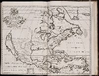
- Published / Created:
- 1704
- Call Number:
- 1973 Folio 70
- Collection Title:
- A new sett of maps, both of antient and present geography ... Together with a Geographical treatise
- Image Count:
- 1
- Resource Type:
- Maps, Atlases & Globes
- Publisher:
- Printed at the Theater
- Collection Created:
- Oxford, Printed at the Theater, 1704
- Found in:
- Beinecke Rare Book and Manuscript Library > A New Map of North America Shewing its Principal Divisions, Chief Cities, Townes, Rivers, Mountains &c. Dedicated to His Highness William Duke of Glocester
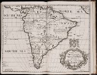
- Published / Created:
- 1704
- Call Number:
- 1973 Folio 70
- Collection Title:
- A new sett of maps, both of antient and present geography ... Together with a Geographical treatise
- Image Count:
- 1
- Resource Type:
- Maps, Atlases & Globes
- Publisher:
- Printed at the Theater
- Collection Created:
- Oxford, Printed at the Theater, 1704
- Found in:
- Beinecke Rare Book and Manuscript Library > A New Map of South America; Shewing its General Divisions, Chief Cities, Towns; Rivers, Mountains &c. Dedicated to His Highness William Duke of Gloucester
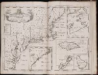
- Published / Created:
- 1704
- Call Number:
- 1973 Folio 70
- Collection Title:
- A new sett of maps, both of antient and present geography ... Together with a Geographical treatise
- Image Count:
- 1
- Resource Type:
- Maps, Atlases & Globes
- Publisher:
- Printed at the Theater
- Collection Created:
- Oxford, Printed at the Theater, 1704
- Found in:
- Beinecke Rare Book and Manuscript Library > A New Map of the Most Considerable Plantations of the English in America. Dedicated to His Highness William Duke of Glocester
- Call Number:
- 1989 +19
- Collection Title:
- A collection of voyages and travels, some now first printed from original manuscripts, others now
- Image Count:
- 1
- Resource Type:
- Maps, Atlases & Globes
- Alternative Title:
- The prospect of Cape Sta. Appollonia. The tree B being at E.N.E about 1 1/4 league
- Description:
- A scale of 22 leagues
- Subject (Geographic):
- Africa and Guinea
- Subject (Topic):
- Voyages and travels
- Collection Created:
- London, Printed by assignment from Messrs. Churchill for H. Lintot and J. Osborn, 1744-46
- Found in:
- Beinecke Rare Book and Manuscript Library > A chart and map of the Gold Coast of Guinea from Rio da Corsa to Ro da Volta. vol. V [5], pl. K