Skip to search
Skip to main content
Skip to first result
Search
You Searched For
Resource Type
Maps, Atlases & Globes
Language
German
Publication Place
[S.l. :
New Search
Search Results
Published / Created:
1918?]
Call Number:
38hc 1918D
Container / Volume:
BRBL_00172
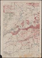
Image Count:
2
Resource Type:
Maps, Atlases & Globes
Description:
"19./6.-26./6./18"., Legend indicates weekly artillery information in red ink, roads, barriers, and trenches in green ink., Ms. annotations in German indicating artillery locations., and Verso: Map of other parts of same regions, with trenches indicated in red ink, new roads indicated in green ink.
Publisher:
s.n.,
Subject (Geographic):
Île-de-France (France)--Military maps and Lorraine (France)--Military maps
Subject (Topic):
World War, 1914-1918--France--Lorraine and World War, 1914-1918--Maps
Found in:
Beinecke Rare Book and Manuscript Library > Gruppe Gorz, Ic/IId No. 62 geh. Artillerie-Wochenkarte mit Truppen und Fliegerbilderkundung.
Published / Created:
1918?]
Call Number:
38hc 1918E
Container / Volume:
BRBL_00172
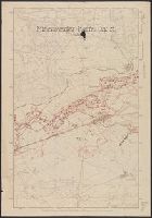
Image Count:
1
Resource Type:
Maps, Atlases & Globes
Description:
Ms. annotations in black and red ink.
Publisher:
s.n.,
Subject (Geographic):
Lorraine (France)--Military maps
Subject (Topic):
World War, 1914-1918--France--Lorraine and World War, 1914-1918--Maps
Found in:
Beinecke Rare Book and Manuscript Library > Minenwerfer-Karte, Div. "H".
Published / Created:
1913
Call Number:
428 Ot9 1913
Container / Volume:
BRBL_00249
Image Count:
4
Resource Type:
Maps, Atlases & Globes
Description:
Blatt I. S. Pitzthal -- Blatt II. S. Sölden-Ranalt -- Blatt III. S. Gurgl -- Blatt IV. S. Weisskugel.
Publisher:
Deutschen u. Oesterreichischen Alpen-Verein,
Subject (Geographic):
Ötztal Alps (Austria and Italy)--Maps and Stubay Alps (Austria)--Maps
Found in:
Beinecke Rare Book and Manuscript Library > Oetzthal & Stubai.
Creator:
Published / Created:
1875?]
Call Number:
44 1870
Container / Volume:
BRBL_00255
Image Count:
1
Resource Type:
Maps, Atlases & Globes
Description:
Inset: Südlicher Theil des Distriktes Sofia.
Publisher:
s.n.,
Subject (Geographic):
Balkan Peninsula--Maps
Found in:
Beinecke Rare Book and Manuscript Library > Original-Karte des Fuerstenthum's Bulgarien und des Balkans nach seinen eigenen Reise-Aufnahmen in den Jahren 1870-74 ausgeführt / von F. Kanitz.
Published / Created:
1875?]
Call Number:
37 Z88 1875
Container / Volume:
BRBL_00150A
Image Count:
1
Resource Type:
Maps, Atlases & Globes
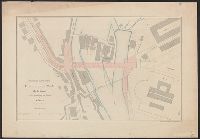
Publisher:
s.n.,
Subject (Geographic):
Zurich (Switzerland)--Maps
Found in:
Beinecke Rare Book and Manuscript Library > Situationsplan zu dem Projecte für eine steinerne Brücke über die Limmat von der Limmatburg zum Bahnhofe in Zürich / Lith. Anstalt. v. J. Wurster u. Comp. in Winterthur.
Published / Created:
[ca. 1940?]
Call Number:
331 D72 1940
Container / Volume:
BRBL_00079
Image Count:
2
Resource Type:
Maps, Atlases & Globes
Description:
Imperfect., Legend on verso., and Strassenverzeichnis (verso).
Publisher:
s.n.],
Subject (Geographic):
Dordrecht (Netherlands)
Found in:
Beinecke Rare Book and Manuscript Library > Stadtplan von Dordrecht.
Published / Created:
1860?]
Call Number:
428 B63 1860
Container / Volume:
BRBL_00248
Image Count:
2
Resource Type:
Maps, Atlases & Globes
Publisher:
s.n.,
Subject (Geographic):
Trentino-Alto Adige (Italy)--Maps
Found in:
Beinecke Rare Book and Manuscript Library > Umgebungs-Karte von Bozen.
Published / Created:
1880
Call Number:
356 K85 1880
Container / Volume:
BRBL_00114
Image Count:
1
Resource Type:
Maps, Atlases & Globes
Publisher:
s.n.],
Subject (Geographic):
Krakow (Poland)--Maps
Found in:
Beinecke Rare Book and Manuscript Library > Umgebungs-karte von Krakau.
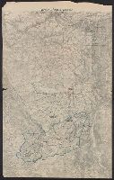
Published / Created:
1918
Call Number:
38hc 1918 Sep. folder
Container / Volume:
BRBL_00172
Image Count:
1
Resource Type:
Maps, Atlases & Globes
Description:
"Druck der Vermess. Abt. 2"., Legend indicates voltage, power lines, transformer stations, power switching stations, front line., Ms. annotations in German. Imperfect: cut around borders., and On verso: Ms. notes: "Komp.-Karte".
Publisher:
s.n.,]
Subject (Geographic):
Lorraine (France)--Maps
Subject (Topic):
Electric lines, World War, 1914-1918--France--Lorraine, and World War, 1914-1918--Maps
Found in:
Beinecke Rare Book and Manuscript Library > Verdun-Point-à-Mousson.
Creator:
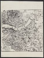
Published / Created:
ca. 1942]
Call Number:
36 L65 1942
Container / Volume:
BRBL_00125
Image Count:
2
Resource Type:
Maps, Atlases & Globes
Description:
[Western sheet] -- [Eastern sheet]., Facsimile., and Stamp on verso: Office of Strategic Services, Map Division, Map Information Section.
Publisher:
OSS,
Subject (Geographic):
Linz (Austria)--Maps
Subject (Name):
United States. Office of Strategic Services Stamp
Found in:
Beinecke Rare Book and Manuscript Library > [Facsimile map of Linz, Austria].
Branch:v1.61.6 ,Deployed:2024-06-12T09:55:37-04:00