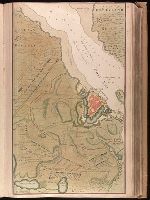
Backed with paper. Ms. no. "13" in upper right-hand corner. Sheet measures 53.6 x 35.5 cm. No. 13 of 87 maps bound together., Bar scale given in "Duytsche Mylen"., Relief shown pictorially; depths shown by soundings., Shows troop positions during siege of Stralsund during the Northern War, ca. 1715., and Title derived from place locations on map.
Publisher:
By Gerard van Keulen ...,
Subject (Geographic):
Rügen Island (Germany)--Maps--Early works to 1800. and Stralsund (Germany)--Maps--Early works to 1800.
Subject (Name):
Anse, Luggert van, fl. 1690-1716, engraver.
Subject (Topic):
Nautical charts--Baltic Sea--Early works to 1800. and Northern War, 1700-1721--Maps.