Skip to search
Skip to main content
Skip to first result
Search
You Searched For
Extent of Digitization
Partially digitized
Format
cartographic
Publication Place
London,
New Search
Search Results
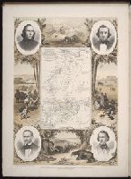
Creator:
Published / Created:
1854
Call Number:
Folio 296
Image Count:
1
Resource Type:
Books, Journals & Pamphlets
Description:
Hand colored map. and In double columns. In portfolio.
Publisher:
Published for the author by E. Stanford; [etc., etc.]
Subject (Geographic):
Africa, Central --Maps and Africa, Central--Description and travel
Subject (Name):
Overweg, Adolf,--1822-1852, Richardson, James,--1806-1851, and Vogel, Eduard,--1829-1856
Found in:
Beinecke Rare Book and Manuscript Library > ... An account of the progress of the expedition to Central Africa, performed by order of Her Majesty's Foreign office, under Messrs. Richardson, Barth, Overweg & Vogel, in the years 1850, 1851, 1852, and 1853. Consisting of maps and illustrations, with descriptive notes, constructed and comp. from official and private materials by Augustus Petermann ...
Creator:
Published / Created:
1773
Call Number:
1979 Folio 59
Image Count:
2
Resource Type:
Maps, Atlases & Globes
Publisher:
Printed for Robert Sayer, map and printseller, at no. 53, in Fleet-Street,
Subject (Geographic):
Scotland --Maps --Early works to 1800
Subject (Name):
Sayer, Robert, 1725-1794
Found in:
Beinecke Rare Book and Manuscript Library > A general atlas, describing the whole universe. Being a compleat and new collection of the most approved maps extant; corrected with the utmost care, and augmented from the latest discoveries: the whole being an improvement of the maps of d'Anville and Robert ... By Thomas Kitchen, senior, and others ...
Creator:
Published / Created:
[178-?]
Call Number:
1973 Folio 113
Image Count:
2
Resource Type:
Maps, Atlases & Globes
Alternative Title:
New and curious set of sixty two maps.
Description:
"The United States of North America, with the British & Spanish territories": no. 46. and Title-page engraved.
Publisher:
Printed for R. Wilkinson, at No. 58 in Cornhill
Subject (Topic):
Atlases--Early works to 1800 and Geography--Early works to 1800
Found in:
Beinecke Rare Book and Manuscript Library > Atlas minor: or A new and curious set of sixty two maps, in which are shewn all the empires, kingdoms, countries, states in all the known parts of the earth ... by Herman Moll ...
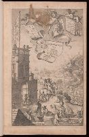
Creator:
Published / Created:
1675
Call Number:
EEdea 675P
Image Count:
2
Alternative Title:
The Road from London to Hith in com. Kent including the road by Maidstone. By John Ogilby Esqr. His Ma.ties Cosmographer
Description:
Added title page engraved, illustrated., Imperfect: engraved title page mutilated. Three maps bound in upside down., No more published., Signatures: 2 l. unsigned, A-E2H2A-Z2Aa-Zz2Aaa-Ddd2, 2 l. unsigned., and Title in red and black; marginal notes; head pieces; initials.
Publisher:
Printed by the author,
Subject (Geographic):
England--Maps, Great Britain--Description and travel, and Wales--Maps
Subject (Topic):
Roads--England and Roads--Wales
Found in:
Beinecke Rare Book and Manuscript Library > Britannia, volume the first, or, An illustration of the kingdom of England and dominion of Wales : by a geographical and historical description of the principal roads thereof : actually admeasured and delineated in a century of whole-sheet copper-sculps : accomodated with the ichnography of the several cities and capital towns : and compleated by an accurate account of the more remarkable passages of antiquity, together with a novel discourse of the present state
Creator:
Published / Created:
1726
Call Number:
BBy11 12
Image Count:
1
Description:
I. An account of all the monuments of Roman antiquity found and collected in that journey ... With a particular description of the Roman walls in Cumberland, Northumberland, and Scotland ... As also a view of the several places of encampment, made by the Romans.--II. An account of the Danish invasions on Scotland, and of the monuments erected there on the different defeats of that people. With other curious remains. and Map measures 47 x 55 cm.
Publisher:
Printed for the author and sold by G. Strahan [etc.]
Subject (Geographic):
Great Britain--Antiquities, Roman
Subject (Topic):
Danes--Scotland and Romans--Great Britain
Found in:
Beinecke Rare Book and Manuscript Library > Itinerarium septentrionale: or, A journey thro' most of the counties of Scotland, and those in the north of England. In two parts ... illustrated with sixty-six copper plates. By Alexander Gordon ....
Branch:v1.61.6 ,Deployed:2024-06-12T09:55:19-04:00